Maps of Zvěstov

Laby - c3785-1-002 - Kaiserpflichtexemplar der Landkarten des stabilen Katasters
1 : 2880
Laby - c3785-1-001 - Kaiserpflichtexemplar der Landkarten des stabilen Katasters
1 : 2880
Libaun - c4050-1-003 - Kaiserpflichtexemplar der Landkarten des stabilen Katasters
1 : 2880
Libaun - c4050-1-001 - Kaiserpflichtexemplar der Landkarten des stabilen Katasters
1 : 2880
Libaun - c4050-1-002 - Kaiserpflichtexemplar der Landkarten des stabilen Katasters
1 : 2880
Begkowitz (Begkowice) - c0701-1-003 - Kaiserpflichtexemplar der Landkarten des stabilen Katasters
1 : 2880
Begkowitz (Begkowice) - c0701-1-004 - Kaiserpflichtexemplar der Landkarten des stabilen Katasters
1 : 2880
Begkowitz (Begkowice) - c0701-1-002 - Kaiserpflichtexemplar der Landkarten des stabilen Katasters
1 : 2880
Begkowitz (Begkowice) - c0701-1-001 - Kaiserpflichtexemplar der Landkarten des stabilen Katasters
1 : 2880
Bořkowice - c0420-1-001 - Kaiserpflichtexemplar der Landkarten des stabilen Katasters
1 : 2880
Bořkowice - c0420-1-002 - Kaiserpflichtexemplar der Landkarten des stabilen Katasters
1 : 2880
Bořkowice - c0420-1-003 - Kaiserpflichtexemplar der Landkarten des stabilen Katasters
1 : 2880


Podrobné mapy zemí Koruny české v měřítku 1:75.000 a mapa vzdáleností všech míst při silnici ležících
1 : 75000 Načeradec (Česko : oblast) Bělohlav, Josef F. Topič
Podrobné mapy zemí Koruny české v měřítku 1:75.000 a mapa vzdáleností všech míst při silnici ležících - Divišov - Vlašim - Načeradec. Průvodce statisticko-historický po všech místech na těchto mapách uvedených a rejstřík věcný názvů hor, potoků, řek, rybníků atd. Sešit 17. List 70,
1 : 75000
Bystřický vikariát
Bystřice (Benešov, Česko)
Selčan und Jung-Woschitz
1 : 75000 Mladá Vožice (Česko : oblast) Hertel, A. K. u. k. Militärgeographisches Institut
Selčan und Jung-Woschitz
1 : 75000 Mladá Vožice (Česko : oblast) K. u. k. Militärgeographisches Institut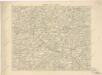
Podrobná místopisná mapa Království Českého

Podrobná mapa Království českého
1 : 100000 Humpolec (Pelhřimov, Česko : oblast) Srp, Jan Jaroslav Bursík
Podrobná místopisná mapa Království Českého

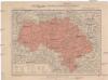
Politický okres Benešov
1 : 100000 Benešov-oblast (Česko) Kratochvíl, M. Josef Richard Vilímek
Politický okres Vlašim
1 : 100000 Vlašim-oblast (Česko) Kratochvíl, M. Josef Richard Vilímek
Politický okres Táborský
1 : 100000 Tábor-oblast (Česko) Srp, Jan Schwihlik, F. Jos. R. Vilímek
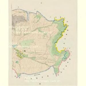
Situační mapka rudního terrainu v Sedlčanské vysočině
Benešov-oblast (Česko)
Selcan und Junc-Woschitz.
from Spezialkarte der osterreichisch-ungarischen Monarchie.
Politický okrec Benešovský
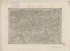
II. vojenské mapování 16
1 : 144000