Maps of Zavlekov

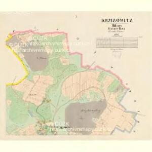
Krzižowitz - c3673-1-002 - Kaiserpflichtexemplar der Landkarten des stabilen Katasters
1 : 2880
Krzižowitz - c3673-1-001 - Kaiserpflichtexemplar der Landkarten des stabilen Katasters
1 : 2880
Katastrální mapa obce Číhaň s osadou Nový Dvůr WC-VII-26 ch
1 : 2880
Planitz (Planice) - c5807-1-006 - Kaiserpflichtexemplar der Landkarten des stabilen Katasters
1 : 2880
Planitz (Planice) - c5807-1-007 - Kaiserpflichtexemplar der Landkarten des stabilen Katasters
1 : 2880
Planitz (Planice) - c5807-1-002 - Kaiserpflichtexemplar der Landkarten des stabilen Katasters
1 : 2880
Planitz (Planice) - c5807-1-001 - Kaiserpflichtexemplar der Landkarten des stabilen Katasters
1 : 2880
Planitz (Planice) - c5807-1-004 - Kaiserpflichtexemplar der Landkarten des stabilen Katasters
1 : 2880
Planitz (Planice) - c5807-1-008 - Kaiserpflichtexemplar der Landkarten des stabilen Katasters
1 : 2880
Planitz (Planice) - c5807-1-005 - Kaiserpflichtexemplar der Landkarten des stabilen Katasters
1 : 2880
Planitz (Planice) - c5807-1-010 - Kaiserpflichtexemplar der Landkarten des stabilen Katasters
1 : 2880
Planitz (Planice) - c5807-1-009 - Kaiserpflichtexemplar der Landkarten des stabilen Katasters
1 : 2880
Planitz (Planice) - c5807-1-003 - Kaiserpflichtexemplar der Landkarten des stabilen Katasters
1 : 2880
Stoborzitz (Stoborzic) - c9206-1-001 - Kaiserpflichtexemplar der Landkarten des stabilen Katasters
1 : 2880
Stoborzitz (Stoborzic) - c9206-1-004 - Kaiserpflichtexemplar der Landkarten des stabilen Katasters
1 : 2880
Stoborzitz (Stoborzic) - c9206-1-002 - Kaiserpflichtexemplar der Landkarten des stabilen Katasters
1 : 2880
Stoborzitz (Stoborzic) - c9206-1-003 - Kaiserpflichtexemplar der Landkarten des stabilen Katasters
1 : 2880
Skrantschitz - c6954-1-002 - Kaiserpflichtexemplar der Landkarten des stabilen Katasters
1 : 2880
Skrantschitz - c6954-1-001 - Kaiserpflichtexemplar der Landkarten des stabilen Katasters
1 : 2880
Katastrální mapa obce Zdebořice
1 : 2880
Planitzka - c5809-1-001 - Kaiserpflichtexemplar der Landkarten des stabilen Katasters
1 : 2880
Katastrální mapa obce Číhaň s osadou Nový Dvůr WC-VII-26 dh
1 : 2880
III. vojenské mapování 4251/3
1 : 25000
Gradkartenblatt
1 : 25000 Nalžovské Hory-oblast (Česko) Albrecht, Julius
III. vojenské mapování 4251/3
1 : 25000
Porostní mapa revíru Týnec
1 : 25000
Hospodářská mapa revíru Číhaň
1 : 2918
Soubor přehledných map pro plánování a statistiku: 4251 – Horažďovice