Maps of Hlavice

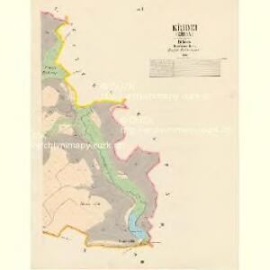
Křidei (Křida) - c3644-1-002 - Kaiserpflichtexemplar der Landkarten des stabilen Katasters
1 : 2880
Křidei (Křida) - c3644-1-001 - Kaiserpflichtexemplar der Landkarten des stabilen Katasters
1 : 2880
Halbenhaupt (Polohlawi) - c5625-1-003 - Kaiserpflichtexemplar der Landkarten des stabilen Katasters
1 : 2880
Halbenhaupt (Polohlawi) - c5625-1-002 - Kaiserpflichtexemplar der Landkarten des stabilen Katasters
1 : 2880
Halbenhaupt (Polohlawi) - c5625-1-001 - Kaiserpflichtexemplar der Landkarten des stabilen Katasters
1 : 2880
Wolschen (Wolsina) - c5462-1-002 - Kaiserpflichtexemplar der Landkarten des stabilen Katasters
1 : 2880
Wolschen (Wolsina) - c5462-1-001 - Kaiserpflichtexemplar der Landkarten des stabilen Katasters
1 : 2880
Wolschen (Wolsina) - c5462-1-004 - Kaiserpflichtexemplar der Landkarten des stabilen Katasters
1 : 2880
Wolschen (Wolsina) - c5462-1-003 - Kaiserpflichtexemplar der Landkarten des stabilen Katasters
1 : 2880
Wapno - c8329-1-003 - Kaiserpflichtexemplar der Landkarten des stabilen Katasters
1 : 2880
Wapno - c8329-1-002 - Kaiserpflichtexemplar der Landkarten des stabilen Katasters
1 : 2880
Wapno - c8329-1-001 - Kaiserpflichtexemplar der Landkarten des stabilen Katasters
1 : 2880
Zetten (Cettenow) - c0748-1-003 - Kaiserpflichtexemplar der Landkarten des stabilen Katasters
1 : 2880
Zetten (Cettenow) - c0748-1-002 - Kaiserpflichtexemplar der Landkarten des stabilen Katasters
1 : 2880
Zetten (Cettenow) - c0748-1-001 - Kaiserpflichtexemplar der Landkarten des stabilen Katasters
1 : 2880

III. vojenské mapování 3754/1
1 : 25000
[Kartenblatt]
1 : 25000 Osečná (Česko : oblast) Reichsamt für Landesaufnahme
Special Karte des politischen Amtsbezirkes Böhm. Leipa
Česká Lípa-oblast (Česko) Jos. Hamann
Turnov
1 : 75000 Turnov (Česko : oblast) Vojenský zeměpisný ústav
III. vojenské mapování 3754
1 : 75000
Turnau
1 : 75000 Mnichovo Hradiště (Česko : oblast) Fitz K. u. k. Militärgeographisches Institut
Turnau
1 : 75000 Mnichovo Hradiště (Česko : oblast) Fitz K. u. k. Militärgeographisches Institut
Turnau
1 : 75000 Turnov (Česko : oblast) K. u. k. Militärgeographisches Institut
Turnov
1 : 75000 Jablonec nad Nisou (Česko : oblast) Vojenský zeměpisný ústav
General-Karte der Fideikommiss Herrschaften Münchengraetz, Weiswasser Hirschberg u. Neuperstein
1 : 71200 Bělá pod Bezdězem-oblast (Česko) Placht, W.
Umgebung von Jičín I.

Umgebung von Jičin
1 : 75000 Jičín (Česko : oblast) K. u. k. militär-geographisches Institut
Mapa okresních hejtmanství Turnovského a Semilského