Maps of Křenice

Krzenitz (Křenic) - c3619-1-002 - Kaiserpflichtexemplar der Landkarten des stabilen Katasters
1 : 2880
Krzenitz (Křenic) - c3619-1-001 - Kaiserpflichtexemplar der Landkarten des stabilen Katasters
1 : 2880
Przetin (Přetin) - c6220-1-003 - Kaiserpflichtexemplar der Landkarten des stabilen Katasters
1 : 2880
Przetin (Přetin) - c6220-1-002 - Kaiserpflichtexemplar der Landkarten des stabilen Katasters
1 : 2880
Przetin (Přetin) - c6220-1-001 - Kaiserpflichtexemplar der Landkarten des stabilen Katasters
1 : 2880
Kameno - c2998-1-001 - Kaiserpflichtexemplar der Landkarten des stabilen Katasters
1 : 2880
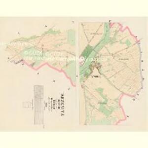
Ptenin - c6273-1-005 - Kaiserpflichtexemplar der Landkarten des stabilen Katasters
1 : 2880
Ptenin - c6273-1-003 - Kaiserpflichtexemplar der Landkarten des stabilen Katasters
1 : 2880
Ptenin - c6273-1-002 - Kaiserpflichtexemplar der Landkarten des stabilen Katasters
1 : 2880
Ptenin - c6273-1-004 - Kaiserpflichtexemplar der Landkarten des stabilen Katasters
1 : 2880
Ptenin - c6273-1-001 - Kaiserpflichtexemplar der Landkarten des stabilen Katasters
1 : 2880
Trntsch (Trnez) - c7970-1-001 - Kaiserpflichtexemplar der Landkarten des stabilen Katasters
1 : 2880
Trntsch (Trnez) - c7970-1-002 - Kaiserpflichtexemplar der Landkarten des stabilen Katasters
1 : 2880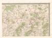
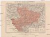
Mapa politického okresu Domažlického


Podrobné mapy zemí Koruny české v měřítku 1:75.000 a mapa vzdáleností všech míst při silnici ležících - Přeštice - Švihov - Klatovy. Průvodce statisticko-historický po všech místech na těchto mapách uvedených a rejstřík věcný názvů hor, potoků, řek, rybníků atd. Sešit 41. List 22,
1 : 75000
Podrobné mapy zemí Koruny české v měřítku 1:75.000 a mapa vzdáleností všech míst při silnici ležících - Přeštice - Švihov - Klatovy. Průvodce statisticko-historický po všech místech na těchto mapách uvedených a rejstřík věcný názvů hor, potoků, řek, rybníků atd. Sešit 41. List 22,
1 : 75000
Podrobné mapy zemí Koruny české v měřítku 1:75.000 a mapy vzdáleností všech míst při silnici ležících
1 : 75000 Klatovy (Česko : oblast) Bělohlav, Josef F. Topič
Podrobná mapa Království českého
1 : 100000 Klatovy (Česko : oblast) Srp, Jan Jaroslav Bursík
Podrobná místopisná mapa Království Českého

Das Tauser Grenzgebiet
1 : 200000 Chodsko (Česko)
Bischofteinitz und Nurschan.
from Spezialkarte der osterreichisch-ungarischen Monarchie.
Spezial Karte von Böhmen
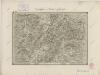
II. vojenské mapování 24
1 : 144000
Taus und Klattau.
from Spezialkarte der osterreichisch-ungarischen Monarchie.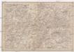
Umgebungen von Klattau und Nepomuk
1 : 750000 Klatovy (Česko : oblast) David, Johann K. k. militär-geographisches Institut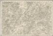
Special - Karte des Koenigreiches Boehmen
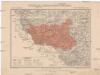
Generální mapa okresního hejtmanství Domažlického
1 : 220000 Domažlice-oblast (Česko) Wagner, Jan Eduard F. Kytka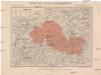
Generální mapa okresního hejtmanství Přeštického
1 : 220000 Přeštice-oblast (Česko) Wagner, Jan Eduard F. Kytka