Maps of okres Pelhřimov

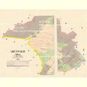
Grünwald - c3589-1-002 - Kaiserpflichtexemplar der Landkarten des stabilen Katasters
1 : 2880
Grünwald - c3589-1-001 - Kaiserpflichtexemplar der Landkarten des stabilen Katasters
1 : 2880
Drahonow - c1496-1-002 - Kaiserpflichtexemplar der Landkarten des stabilen Katasters
1 : 2880
Drahonow - c1496-1-001 - Kaiserpflichtexemplar der Landkarten des stabilen Katasters
1 : 2880
Střiterz - c7485-1-004 - Kaiserpflichtexemplar der Landkarten des stabilen Katasters
1 : 2880
Střiterz - c7485-1-003 - Kaiserpflichtexemplar der Landkarten des stabilen Katasters
1 : 2880
Střiterz - c7485-1-002 - Kaiserpflichtexemplar der Landkarten des stabilen Katasters
1 : 2880
Střiterz - c7485-1-001 - Kaiserpflichtexemplar der Landkarten des stabilen Katasters
1 : 2880
Markwaretz - c4482-1-002 - Kaiserpflichtexemplar der Landkarten des stabilen Katasters
1 : 2880
Markwaretz - c4482-1-004 - Kaiserpflichtexemplar der Landkarten des stabilen Katasters
1 : 2880
Markwaretz - c4482-1-001 - Kaiserpflichtexemplar der Landkarten des stabilen Katasters
1 : 2880
Markwaretz - c4482-1-003 - Kaiserpflichtexemplar der Landkarten des stabilen Katasters
1 : 2880
Borr - c0359-1-002 - Kaiserpflichtexemplar der Landkarten des stabilen Katasters
1 : 2880
Borr - c0359-1-001 - Kaiserpflichtexemplar der Landkarten des stabilen Katasters
1 : 2880
Okolí Novo-Cerekvické, na 2 hod. cesty
Nová Cerekev-oblast (Česko) Pavlík
[Gradkartenblatt]
1 : 25000 Horní Cerekev-oblast (Česko) Vojenský zeměpisný ústav

Podrobné mapy zemí Koruny české v měřítku 1:75.000 a mapy vzdáleností všech míst při silnici ležících
1 : 75000 Kamenice nad Lipou-oblast (Česko) Bělohlav, Josef F. Topič
Podrobné mapy zemí Koruny české v měřítku 1:75.000 a mapa vzdáleností všech míst při silnici ležících - Kamenice nad Lípou - Černovice. Průvodce statisticko-historický po všech místech na těchto mapách uvedených a rejstřík věcný názvů hor, potoků, řek, rybníků atd. Sešit 48. List 72,
1 : 75000
Gradkartenblatt
1 : 25000 Horní Cerekev-oblast (Česko) Bulla, Eduard
III. vojenské mapování 4254
1 : 75000
Pelhřimov
1 : 75000 Pelhřimov-oblast (Česko) Vojenský zeměpisný ústav
Pelhřimov
1 : 75000 Pelhřimov (Česko : oblast) Vojenský zeměpisný ústav
Mapy plánování ČSR

Soubor přehledných map pro plánování a statistiku: 4254 – Pelhřimov

Kamenitz a/d. Linde
1 : 75000 Kamenice nad Lipou (Česko : oblast) Fenzl K. u. k. militär-geographisches Institut
Kamenitz a/d. Linde
1 : 75000 Kamenice nad Lipou (Česko : oblast) Fenzl K. u. k. Militärgeographisches Institut
Kamenitz a/d. Linde
1 : 75000 Kamenice nad Lipou (Česko : oblast) K. u. k. Militärgeographisches Institut
Podrobná místopisná mapa Království Českého