Maps of Manětín

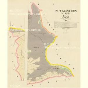
Kottanschen (Kotanec) - c3410-1-001 - Kaiserpflichtexemplar der Landkarten des stabilen Katasters
1 : 2880
Kottanschen (Kotanec) - c3410-1-002 - Kaiserpflichtexemplar der Landkarten des stabilen Katasters
1 : 2880
Hospodářská mapa polesí Vranov
1 : 4320
Katastrální mapa obce Kotaneč WC-IX-16 ah ai
1 : 2880
Katastrální mapa obce Kotaneč
1 : 2880
Hospodářská mapa katastrálního území Vysočany
1 : 2880
Katastrální mapa obce Kotaneč WC-IX-17 ae
1 : 2880
Katastrální mapa obce Vysočany
1 : 2880
Hospodářská mapa polesí Hrádek
1 : 5760
Katastrální mapa obce Hrádek WC-IX-16 bi ai
1 : 2880
Katastrální mapa města Rabštejn
1 : 2880
Hospodářská mapa polesí Rabštejn-Kalec
1 : 11520
Wissotschan (Wisočany) - c8934-1-002 - Kaiserpflichtexemplar der Landkarten des stabilen Katasters
1 : 2880
Wissotschan (Wisočany) - c8934-1-001 - Kaiserpflichtexemplar der Landkarten des stabilen Katasters
1 : 2880
Wissotschan (Wisočany) - c8934-1-003 - Kaiserpflichtexemplar der Landkarten des stabilen Katasters
1 : 2880
Kalletz (Kalec) - c2979-1-003 - Kaiserpflichtexemplar der Landkarten des stabilen Katasters
1 : 2880
Kalletz (Kalec) - c2979-1-002 - Kaiserpflichtexemplar der Landkarten des stabilen Katasters
1 : 2880
Kalletz (Kalec) - c2979-1-001 - Kaiserpflichtexemplar der Landkarten des stabilen Katasters
1 : 2880
Porostní mapa polesí Rabštejn
1 : 5760
Rabenstein (Wranow) - c6299-1-001 - Kaiserpflichtexemplar der Landkarten des stabilen Katasters
1 : 2880
Rabenstein (Wranow) - c6299-1-004 - Kaiserpflichtexemplar der Landkarten des stabilen Katasters
1 : 2880
Rabenstein (Wranow) - c6299-1-003 - Kaiserpflichtexemplar der Landkarten des stabilen Katasters
1 : 2880
Rabenstein (Wranow) - c6299-1-005 - Kaiserpflichtexemplar der Landkarten des stabilen Katasters
1 : 2880
Rabenstein (Wranow) - c6299-1-002 - Kaiserpflichtexemplar der Landkarten des stabilen Katasters
1 : 2880
Hospodářská mapa polesí Vranov
1 : 4320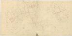
Hospodářská mapa polesí Kalec
1 : 2880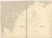
Katastrální mapa města Rabštejn WC-VIII-16 dh ch
1 : 2880
Hlubocka (Hluboky) - c1890-1-001 - Kaiserpflichtexemplar der Landkarten des stabilen Katasters
1 : 2880
Hlubocka (Hluboky) - c1890-1-003 - Kaiserpflichtexemplar der Landkarten des stabilen Katasters
1 : 2880