Maps of Mochtín

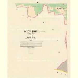
Kozaurow (Kocaurow) - c3237-1-002 - Kaiserpflichtexemplar der Landkarten des stabilen Katasters
1 : 2880
Kozaurow (Kocaurow) - c3237-1-004 - Kaiserpflichtexemplar der Landkarten des stabilen Katasters
1 : 2880
Kozaurow (Kocaurow) - c3237-1-003 - Kaiserpflichtexemplar der Landkarten des stabilen Katasters
1 : 2880
Kozaurow (Kocaurow) - c3237-1-001 - Kaiserpflichtexemplar der Landkarten des stabilen Katasters
1 : 2880
Lhutta - c3969-1-002 - Kaiserpflichtexemplar der Landkarten des stabilen Katasters
1 : 2880
Lhutta - c3969-1-001 - Kaiserpflichtexemplar der Landkarten des stabilen Katasters
1 : 2880
Katastrální mapa obce Lhůta
1 : 2880
Tieschetin (Těssetin) - c7890-1-003 - Kaiserpflichtexemplar der Landkarten des stabilen Katasters
1 : 2880
Tieschetin (Těssetin) - c7890-1-002 - Kaiserpflichtexemplar der Landkarten des stabilen Katasters
1 : 2880
Tieschetin (Těssetin) - c7890-1-001 - Kaiserpflichtexemplar der Landkarten des stabilen Katasters
1 : 2880
Katastrální mapa obce Mochtín
1 : 2880
Katastrální mapa obce Mochtín
1 : 2880
Katastrální mapa obce Zdebořice
1 : 2880
Porostní mapa revíru Těšetiny
1 : 5000
Klein-Hoschtitz (Maly Hosstice) - c2267-1-002 - Kaiserpflichtexemplar der Landkarten des stabilen Katasters
1 : 2880
Klein-Hoschtitz (Maly Hosstice) - c2267-1-001 - Kaiserpflichtexemplar der Landkarten des stabilen Katasters
1 : 2880
Porostní mapa hájenství Těšetiny
1 : 5000
Porostní mapa revíru Těšetiny
1 : 5000
Mochtin - c4809-1-003 - Kaiserpflichtexemplar der Landkarten des stabilen Katasters
1 : 2880
Mochtin - c4809-1-001 - Kaiserpflichtexemplar der Landkarten des stabilen Katasters
1 : 2880
Mochtin - c4809-1-002 - Kaiserpflichtexemplar der Landkarten des stabilen Katasters
1 : 2880
Stoborzitz (Stoborzic) - c9206-1-001 - Kaiserpflichtexemplar der Landkarten des stabilen Katasters
1 : 2880
Stoborzitz (Stoborzic) - c9206-1-004 - Kaiserpflichtexemplar der Landkarten des stabilen Katasters
1 : 2880
Stoborzitz (Stoborzic) - c9206-1-002 - Kaiserpflichtexemplar der Landkarten des stabilen Katasters
1 : 2880
Stoborzitz (Stoborzic) - c9206-1-003 - Kaiserpflichtexemplar der Landkarten des stabilen Katasters
1 : 2880
Bistry - c0713-1-002 - Kaiserpflichtexemplar der Landkarten des stabilen Katasters
1 : 2880
Bistry - c0713-1-001 - Kaiserpflichtexemplar der Landkarten des stabilen Katasters
1 : 2880
Katastrální mapa obce Těšetiny
1 : 2880
Porostní mapa revíru Těšetiny
1 : 5000