Maps of Řetůvka

Gerhartitz (Kerhartice) - c3094-2-002 - Kaiserpflichtexemplar der Landkarten des stabilen Katasters
1 : 2880
Gerhartitz (Kerhartice) - c3094-2-001 - Kaiserpflichtexemplar der Landkarten des stabilen Katasters
1 : 2880
Kerhartitz (Kerhartice) - c3094-1-002 - Kaiserpflichtexemplar der Landkarten des stabilen Katasters
1 : 2880
Kerhartitz (Kerhartice) - c3094-1-001 - Kaiserpflichtexemplar der Landkarten des stabilen Katasters
1 : 2880
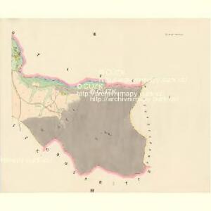
Klein-Ritte (Mala-Rzetowa) - c6711-1-001 - Kaiserpflichtexemplar der Landkarten des stabilen Katasters
1 : 2880
Klein-Ritte (Mala-Rzetowa) - c6711-1-002 - Kaiserpflichtexemplar der Landkarten des stabilen Katasters
1 : 2880
Klein-Ritte (Mala-Rzetowa) - c6711-1-003 - Kaiserpflichtexemplar der Landkarten des stabilen Katasters
1 : 2880
[Kartenblatt]
1 : 25000 Dolní Čermná (Česko) Reichsamt für Landesaufnahme
Gradkartenblatt
1 : 25000 Čechy (Česko) Fromm, Hermann
III. vojenské mapování 4057/1
1 : 25000
III. vojenské mapování 4057/1
1 : 25000
III. vojenské mapování 4057/1
1 : 25000


8. Kraj Pardubický

Hejtmanství Lytomyšlské

Landskron und Mhr. Trübau
1 : 75000 Lanškroun (Česko : oblast) Scherling K. u. k. Militärgeographisches Institut
Landskron und Mhr. Trübau
1 : 75000 Lanškroun (Česko : oblast) K. u. k. Militärgeographisches Institut
III. vojenské mapování 4057
1 : 75000
Zone 6, Col. XV, Landskron und Mhr. Trübau, uit: Geologische Karte der im Reichsrathe vertretenen Königreiche und Länder der Österreich-Ungarischen Monarchie : auf Grundlage der Specialkarte i.M. 1:75.000 des k.u.k. Militär-geographischen Institutes / neu bearb. und als Kartenwerk von 341 Blattnummern in zwanglosen Lfg. hrsg. durch die k.k. Geologische Reichsanstalt in Wien
1 : 75000 titelvariant: Geologische Spezialkarte der im Reichsrate vertretenen Königreiche und Länder der Österreichisch-Ungarischen Monarchie; Geologische Specialkarte der im Reichsrathe vertretenen Königreiche und Länder der Österreichisch-Ungarischen Monarchie; Annotatie: Titel bovenaan kaartblad: Geologische Spezialkarte der im Reichsrate vertretenen Königreiche und Länder der Österreichisch-Ungarischen Monarchie en Geologische Specialkarte der im Reichsrathe vertretenen Königreiche und Länder der Österreichisch-Ungarischen Monarchie; Annotatie geografische gegevens: Coördinaten gebaseerd op nulmeridiaan van Ferro (Hierro) Kaiserlich-Königliche Geologische Reichsanstalt, Wenen Wien : K.K. Geologische Reichsanstalt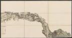
Eisenbahn Karte Wien-Dresden, Ollmütz-Trübau
1 : 72000 Blatt 8 Minarzik, Anselm J. Rauh
II. vojenské mapování 3
1 : 144000
Choceň a okolí
1 : 75000 Choceň (Česko : oblast) Vojenský zeměpisný ústav
Podrobná mapa Království českého
1 : 100000 Rychnov nad Kněžnou (Česko : oblast) Srp, Jan Jaroslav Bursík
Silniční mapa zámeckého panství Litomyšl
1 : 100300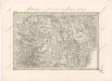
Special - Karte des Koenigreiches Boehmen

Landskorn und Mhr. Trubau.
from Spezialkarte der osterreichisch-ungarischen Monarchie.
Hohenmauth und Leitomischl.
from Spezialkarte der osterreichisch-ungarischen Monarchie.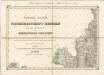
II. vojenské mapování 3
1 : 144000