Maps of Švihov

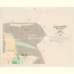
Kallischt (Kallisste) - c2987-1-002 - Kaiserpflichtexemplar der Landkarten des stabilen Katasters
1 : 2880
Kallischt (Kallisste) - c2987-1-001 - Kaiserpflichtexemplar der Landkarten des stabilen Katasters
1 : 2880
Kallischt (Kallisste) - c2987-1-003 - Kaiserpflichtexemplar der Landkarten des stabilen Katasters
1 : 2880
Klein Strzebegzin (Mala Střebegcynka) - c8062-1-002 - Kaiserpflichtexemplar der Landkarten des stabilen Katasters
1 : 2880
Klein Strzebegzin (Mala Střebegcynka) - c8062-1-001 - Kaiserpflichtexemplar der Landkarten des stabilen Katasters
1 : 2880
Ginno (Cyno) - c2917-1-002 - Kaiserpflichtexemplar der Landkarten des stabilen Katasters
1 : 2880
Ginno (Cyno) - c2917-1-001 - Kaiserpflichtexemplar der Landkarten des stabilen Katasters
1 : 2880
Rothporitschen (Czerwena Porzicz) - c0927-1-002 - Kaiserpflichtexemplar der Landkarten des stabilen Katasters
1 : 2880
Rothporitschen (Czerwena Porzicz) - c0927-1-001 - Kaiserpflichtexemplar der Landkarten des stabilen Katasters
1 : 2880
Rothporitschen (Czerwena Porzicz) - c0927-1-003 - Kaiserpflichtexemplar der Landkarten des stabilen Katasters
1 : 2880
Rothporitschen (Czerwena Porzicz) - c0927-1-004 - Kaiserpflichtexemplar der Landkarten des stabilen Katasters
1 : 2880
Kbell - c3078-1-001 - Kaiserpflichtexemplar der Landkarten des stabilen Katasters
1 : 2880
Kbell - c3078-1-002 - Kaiserpflichtexemplar der Landkarten des stabilen Katasters
1 : 2880
Kbell - c3078-1-003 - Kaiserpflichtexemplar der Landkarten des stabilen Katasters
1 : 2880
Kbell - c3078-1-004 - Kaiserpflichtexemplar der Landkarten des stabilen Katasters
1 : 2880
Hospodářská mapa lesů velkostatku - hájenství Vlčí
1 : 2880
Katastrální mapa obce Vlčí
1 : 2880
Mapa zastupitelského okresu Přeštického

III. vojenské mapování 4250/2
1 : 25000

Podrobné mapy zemí Koruny české v měřítku 1:75.000 a mapa vzdáleností všech míst při silnici ležících - Přeštice - Švihov - Klatovy. Průvodce statisticko-historický po všech místech na těchto mapách uvedených a rejstřík věcný názvů hor, potoků, řek, rybníků atd. Sešit 41. List 22,
1 : 75000
Podrobné mapy zemí Koruny české v měřítku 1:75.000 a mapa vzdáleností všech míst při silnici ležících - Přeštice - Švihov - Klatovy. Průvodce statisticko-historický po všech místech na těchto mapách uvedených a rejstřík věcný názvů hor, potoků, řek, rybníků atd. Sešit 41. List 22,
1 : 75000
Podrobné mapy zemí Koruny české v měřítku 1:75.000 a mapy vzdáleností všech míst při silnici ležících
1 : 75000 Klatovy (Česko : oblast) Bělohlav, Josef F. Topič
Podrobná mapa Království českého
1 : 100000 Klatovy (Česko : oblast) Srp, Jan Jaroslav Bursík
Podrobná místopisná mapa Království Českého
Příruční mapa Československé republiky

Okresní hejtmanství Klatovské
1 : 100000 Klatovy-oblast (Česko) Srp, Jan Jos. R. Vilímek
Bischofteinitz und Nurschan.
from Spezialkarte der osterreichisch-ungarischen Monarchie.
Pilsen und Blowitz.
from Spezialkarte der osterreichisch-ungarischen Monarchie.