Maps of Chraštice

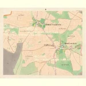
Gross Chraschtitz - c2647-1-005 - Kaiserpflichtexemplar der Landkarten des stabilen Katasters
1 : 2880
Gross Chraschtitz - c2647-1-004 - Kaiserpflichtexemplar der Landkarten des stabilen Katasters
1 : 2880
Gross Chraschtitz - c2647-1-001 - Kaiserpflichtexemplar der Landkarten des stabilen Katasters
1 : 2880
Gross Chraschtitz - c2647-1-003 - Kaiserpflichtexemplar der Landkarten des stabilen Katasters
1 : 2880
Gross Chraschtitz - c2647-1-002 - Kaiserpflichtexemplar der Landkarten des stabilen Katasters
1 : 2880
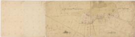
Mapa dvora Řeteč 1
1 : 2880
Mapa dvora Řeteč 1
1 : 5760
Mapa dvora Řeteč 1
1 : 5760
Swuschitz - c7663-1-002 - Kaiserpflichtexemplar der Landkarten des stabilen Katasters
1 : 2880
Swuschitz - c7663-1-001 - Kaiserpflichtexemplar der Landkarten des stabilen Katasters
1 : 2880
Mapa dvora Chraštiček 1

Kletitz - c3157-1-001 - Kaiserpflichtexemplar der Landkarten des stabilen Katasters
1 : 2880
Kletitz - c3157-1-002 - Kaiserpflichtexemplar der Landkarten des stabilen Katasters
1 : 2880
Chraštice s Chraštičkami a Řetčí, okr. Písek, list 1 1

Chraštice s Chraštičkami a Řetčí, okr. Písek, list 7 1
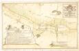
Geometrický nárys části hranic mezi panstvím orlickým a statkem Bukovany z r. 1766, díl C 1
Bukovany se Sedlečkem, okr. Příbram, list 2 1

Mapa dvora Bukovan 1
Zalužany, okr. Příbram, list 7 list 7
1 : 2880
Zbenice, okr. Příbram, list 1 list 1
1 : 2880
Brzezy, Prach[iner] Kr[eis]
1 : 2880 Březnice (Příbram, Česko : oblast)
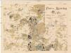
Přehledná mapa rybníků velkostatku Orlík, list 3 1
Panství Vorlík [sic]
1 : 25000 Orlík nad Vltavou-oblast (Česko) Jiskra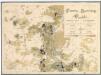
Porostní mapa severní části velkostatku orlického pro vycházku České lesnické jednoty v měsíci srpnu 1893 1
1 : 25000
Přehledná mapa pozemkové držby velkostatku orlického v širším pojetí, podle stavu z roku 1916, list 3 1
1 : 25000
Výřez z přehledné mapy velkostatku Orlíka z r. 1913 s vyznačením pozemků dvorů Horosedly, Lety, Mirovice a Nerestce 1
1 : 25000
Kozarowitz - c3442-1-004 - Kaiserpflichtexemplar der Landkarten des stabilen Katasters
1 : 2880
Kozarowitz - c3442-1-003 - Kaiserpflichtexemplar der Landkarten des stabilen Katasters
1 : 2880
Kozarowitz - c3442-1-002 - Kaiserpflichtexemplar der Landkarten des stabilen Katasters
1 : 2880