Maps of Všeruby

Chräntschowitz - c2625-1-002 - Kaiserpflichtexemplar der Landkarten des stabilen Katasters
1 : 2880
Chräntschowitz - c2625-1-003 - Kaiserpflichtexemplar der Landkarten des stabilen Katasters
1 : 2880
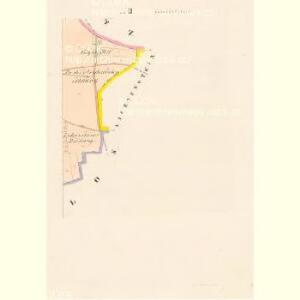
Chräntschowitz - c2625-1-001 - Kaiserpflichtexemplar der Landkarten des stabilen Katasters
1 : 2880
Naglos - c4954-1-002 - Kaiserpflichtexemplar der Landkarten des stabilen Katasters
1 : 2880
Naglos - c4954-1-001 - Kaiserpflichtexemplar der Landkarten des stabilen Katasters
1 : 2880
Seslas - c0565-1-001 - Kaiserpflichtexemplar der Landkarten des stabilen Katasters
1 : 2880
Seslas - c0565-1-002 - Kaiserpflichtexemplar der Landkarten des stabilen Katasters
1 : 2880
Popplowitz - c6022-1-001 - Kaiserpflichtexemplar der Landkarten des stabilen Katasters
1 : 2880
Popplowitz - c6022-1-002 - Kaiserpflichtexemplar der Landkarten des stabilen Katasters
1 : 2880
Chrast - c2638-1-002 - Kaiserpflichtexemplar der Landkarten des stabilen Katasters
1 : 2880
Chrast - c2638-1-001 - Kaiserpflichtexemplar der Landkarten des stabilen Katasters
1 : 2880
Pichl - c4094-2-002 - Kaiserpflichtexemplar der Landkarten des stabilen Katasters
1 : 2880
Pichl - c4094-2-001 - Kaiserpflichtexemplar der Landkarten des stabilen Katasters
1 : 2880
[Kartenblatt]
1 : 25000 Město Touškov (Česko : oblast) Reichsamt für Landesaufnahme
III. vojenské mapování 4050/4
1 : 25000
Gradkartenblatt
1 : 25000 Město Touškov-oblast (Česko) Brzesina, Julius von

Plzeň a okolí
1 : 75000 Plzeň (Česko : oblast) Vojenský zeměpisný ústav
III. vojenské mapování 4050
1 : 75000
Stříbro a okolí
1 : 75000 Stříbro (Česko : oblast) Vojenský zeměpisný ústav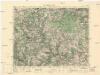
Město Teplá
1 : 75000 Teplá (Cheb, Česko : oblast) Vojenský zeměpisný ústav
Město Teplá
1 : 75000 Teplá-oblast (Cheb, Česko) Vojenský zeměpisný ústav
Tepl und Tuschkau
1 : 75000 Město Touškov (Česko : oblast) Bloschitz, Rudolf K. u. k. Militärgeographisches Institut
Tepl und Tuschkau
1 : 75000 Město Touškov-oblast (Česko) K. u. k. Militärgeographisches Institut
Teplá
1 : 75000 Bezdružice (Česko : oblast) Vojenský zeměpisný ústav
Katastrální mapa obce Kopidlo-Kočín
1 : 2880
Podrobná mapa Království českého
1 : 100000 Plzeň (Česko : oblast) Srp, Jan Jaroslav Bursík
[Umgebung von Pilsen]
1 : 75000 Plzeň (Česko : oblast) K. u. k. Militärgeographisches Institut
Umgebungskarte von Pilsen