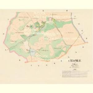
Maps of Chomle

Chomle - c2564-1-001 - Kaiserpflichtexemplar der Landkarten des stabilen Katasters
1 : 2880
Chomle - c2564-1-002 - Kaiserpflichtexemplar der Landkarten des stabilen Katasters
1 : 2880
Klein Lohowitz, Rakonitzer Kr[eis]
1 : 2880 Hlohovičky (Hlohovice, Česko)
Weywanow (Wegwanow) - c8348-1-001 - Kaiserpflichtexemplar der Landkarten des stabilen Katasters
1 : 2880
Weywanow (Wegwanow) - c8348-1-002 - Kaiserpflichtexemplar der Landkarten des stabilen Katasters
1 : 2880
Weywanow (Wegwanow) - c8348-1-005 - Kaiserpflichtexemplar der Landkarten des stabilen Katasters
1 : 2880
Weywanow (Wegwanow) - c8348-1-003 - Kaiserpflichtexemplar der Landkarten des stabilen Katasters
1 : 2880
Weywanow (Wegwanow) - c8348-1-004 - Kaiserpflichtexemplar der Landkarten des stabilen Katasters
1 : 2880
Skomelno - c6942-1-002 - Kaiserpflichtexemplar der Landkarten des stabilen Katasters
1 : 2880
Skomelno - c6942-1-001 - Kaiserpflichtexemplar der Landkarten des stabilen Katasters
1 : 2880
III. vojenské mapování 4051/4
1 : 25000
III. vojenské mapování 4051/4
1 : 25000
Gradkartenblatt
1 : 25000 Mýto (Rokycany, Česko) Bulla, Eduard

Podrobné mapy zemí Koruny české v měřítku 1:75.000 a mapa vzdáleností všech míst při silnici ležících.. Průvodce statisticko-historický po všech místech na těchto mapách uvedených a rejstřík věcný názvů hor, potoků, řek, rybníků atd. Sešit 28. List 30,
1 : 75000
Karte des Zbirower Bezirkes im Prager Kreise
1 : 72300 Zbiroh-oblast (Česko) Wagner, Jan Eduard Karl André
Kralovice
1 : 75000 Kralovice (Plzeň-sever, Česko : oblast) Vojenský zeměpisný ústav
Kralowitz und Břas
1 : 75000 Břasy (Česko : oblast) Schulenburg, J. K. u. k. Militärgeographisches Institut
Kralowitz und Břas
1 : 75000 Břasy-oblast (Česko) K. u. k. Militärgeographisches Institut
Mapa školního a politického okresu Rokycanského
1 : 75000 Rokycany-oblast (Česko) Voj. zeměpisný ústav
[Umgebung von Kralowitz]
1 : 75000 Kralovice (Plzeň-sever, Česko : oblast) K. u. k. Militärgeographisches Institut
Kralovice a okolí
1 : 75000 Kralovice (Plzeň-sever, Česko : oblast) Vojenský zeměpisný ústav
Kralovice
1 : 75000 Kralovice-oblast (Plzeň-sever, Česko) Vojenský zeměpisný ústav
Kralovice
1 : 75000 Kralovice (Plzeň-sever, Česko : oblast) Vojenský zeměpisný ústav
Rokycany a okolí
1 : 75000 Rokycany (Česko : oblast) Vojenský zeměpisný ústav
Katastrální mapa obce Kopidlo-Kočín
1 : 2880
III. vojenské mapování 4051
1 : 75000
Soubor map okresů Pražského kraje

General Karte von der hochfürstlich von Metternich'schen Herrschaft Plass mit den vereinten Gütern Katzerow Kraschau u. Biela
1 : 150000 Horní Bělá-oblast (Česko) Wiehl, Anton Metternich, Klemens Wenzel Nepomuk Lothar von