Maps of Chodová Planá

Kuttenplan - c2556-1-006 - Kaiserpflichtexemplar der Landkarten des stabilen Katasters
1 : 2880
Kuttenplan - c2556-1-007 - Kaiserpflichtexemplar der Landkarten des stabilen Katasters
1 : 2880
Kuttenplan - c2556-1-003 - Kaiserpflichtexemplar der Landkarten des stabilen Katasters
1 : 2880
Kuttenplan - c2556-1-001 - Kaiserpflichtexemplar der Landkarten des stabilen Katasters
1 : 2880
Kuttenplan - c2556-1-005 - Kaiserpflichtexemplar der Landkarten des stabilen Katasters
1 : 2880
Kuttenplan - c2556-1-002 - Kaiserpflichtexemplar der Landkarten des stabilen Katasters
1 : 2880
Kuttenplan - c2556-1-004 - Kaiserpflichtexemplar der Landkarten des stabilen Katasters
1 : 2880
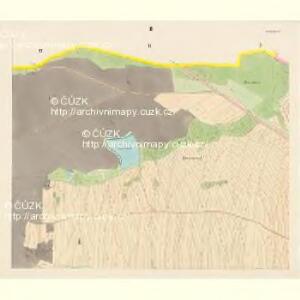
Hospodářská a porostní mapa revíru Plánská Huť
1 : 2880
Unter Gramling (Dolnj Gramolin) - c1313-1-002 - Kaiserpflichtexemplar der Landkarten des stabilen Katasters
1 : 2880
Unter Gramling (Dolnj Gramolin) - c1313-1-003 - Kaiserpflichtexemplar der Landkarten des stabilen Katasters
1 : 2880
Unter Gramling (Dolnj Gramolin) - c1313-1-001 - Kaiserpflichtexemplar der Landkarten des stabilen Katasters
1 : 2880
Neudorf - c7999-1-002 - Kaiserpflichtexemplar der Landkarten des stabilen Katasters
1 : 2880
Neudorf - c7999-1-005 - Kaiserpflichtexemplar der Landkarten des stabilen Katasters
1 : 2880
Neudorf - c7999-1-001 - Kaiserpflichtexemplar der Landkarten des stabilen Katasters
1 : 2880
Neudorf - c7999-1-006 - Kaiserpflichtexemplar der Landkarten des stabilen Katasters
1 : 2880
Neudorf - c7999-1-004 - Kaiserpflichtexemplar der Landkarten des stabilen Katasters
1 : 2880
Neudorf - c7999-1-003 - Kaiserpflichtexemplar der Landkarten des stabilen Katasters
1 : 2880
Khoau - c3767-1-002 - Kaiserpflichtexemplar der Landkarten des stabilen Katasters
1 : 2880
Khoau - c3767-1-001 - Kaiserpflichtexemplar der Landkarten des stabilen Katasters
1 : 2880
Katastrální mapa obce Výškov
1 : 2880
Waschagrün - c8975-1-002 - Kaiserpflichtexemplar der Landkarten des stabilen Katasters
1 : 2880
Waschagrün - c8975-1-003 - Kaiserpflichtexemplar der Landkarten des stabilen Katasters
1 : 2880
Waschagrün - c8975-1-001 - Kaiserpflichtexemplar der Landkarten des stabilen Katasters
1 : 2880
Přehledná mapa panství Planá
1 : 25000
Gradkartenblatt
1 : 25000 Mariánské Lázně-oblast (Česko) Böhm, Karl
[Kartenblatt]
1 : 25000 Chodová Planá (Česko : oblast) Reichsamt für Landesaufnahme
III. vojenské mapování 4049/2
1 : 25000

Entwurff der freyherrl. Haimhausischen Herrshafft Kuttenplan wie solche anno 1676 in Esse sich befunden
Chodová Planá-oblast (Česko)
Unter Godrisch - c1300-1-003 - Kaiserpflichtexemplar der Landkarten des stabilen Katasters
1 : 2880
Unter Godrisch - c1300-1-001 - Kaiserpflichtexemplar der Landkarten des stabilen Katasters
1 : 2880
Unter Godrisch - c1300-1-005 - Kaiserpflichtexemplar der Landkarten des stabilen Katasters
1 : 2880
Unter Godrisch - c1300-1-002 - Kaiserpflichtexemplar der Landkarten des stabilen Katasters
1 : 2880