Maps of Hrobice

Hrobitz - c2355-1-001 - Kaiserpflichtexemplar der Landkarten des stabilen Katasters
1 : 2880
Hrobitz - c2355-1-002 - Kaiserpflichtexemplar der Landkarten des stabilen Katasters
1 : 2880
Indikační skica mapy stabilního katastru pro obec Dříteč III., V.
1 : 2880
Indikační skica mapy stabilního katastru pro obec Čeperka VI.
1 : 2880
Indikační skica mapy stabilního katastru pro obec Čeperka IX.
1 : 2880
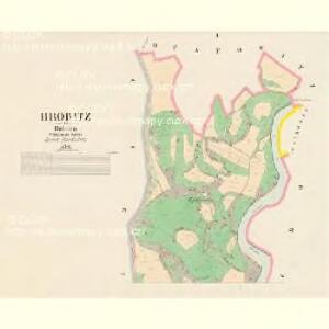
Indikační skica mapy stabilního katastru pro obec Hrobice I.
1 : 2880
Indikační skica mapy stabilního katastru pro obec Bukovina nad Labem II.
1 : 2880
Indikační skica mapy stabilního katastru pro obec Čeperka X.
1 : 2880
Indikační skica mapy stabilního katastru pro obec Dříteč I.-VI.
1 : 2880
Indikační skica mapy stabilního katastru pro obec Čeperka I.-X.
1 : 2880
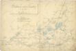
Mapa rybníka Velká Čeperka s okolím
1 : 7294
Porostní mapa revíru Čeperka stav z počátku roku 1897
1 : 10000
Porostní mapa revíru Čeperka stav z počátku roku 1897
1 : 10000
Drzitsch - c1573-1-004 - Kaiserpflichtexemplar der Landkarten des stabilen Katasters
1 : 2880
Drzitsch - c1573-1-001 - Kaiserpflichtexemplar der Landkarten des stabilen Katasters
1 : 2880
Drzitsch - c1573-1-002 - Kaiserpflichtexemplar der Landkarten des stabilen Katasters
1 : 2880
Drzitsch - c1573-1-003 - Kaiserpflichtexemplar der Landkarten des stabilen Katasters
1 : 2880
Porostní mapa revíru Čeperka stav z počátku roku 1897
1 : 10000
Katastrální mapa Velké Čeperky
1 : 2858
Porostní mapa revíru Čeperka stav z počátku roku 1897
1 : 10000
Mapa pozemků bývalého rybníka Velká Čeperka II.
1 : 2880
Niemtschitz - c5126-1-002 - Kaiserpflichtexemplar der Landkarten des stabilen Katasters
1 : 2880
Niemtschitz - c5126-1-001 - Kaiserpflichtexemplar der Landkarten des stabilen Katasters
1 : 2880
Mapa rybníka Baroch
1 : 2000
Indikační skica mapy stabilního katastru pro obec Libišany I.-V.
1 : 2880
Uibersichtskarte der Daschitzer Domänenforste 1871
Dašice-oblast (Česko) Le-Monnier, Franz von Šafařík, Pavel Josef Verlag des böhm. Forst Vereins
Uibersichtskarte der Daschitzer Domänenforste 1871
Dašice-oblast (Česko) Le-Monnier, Franz von Šafařík, Pavel Josef
Některé vodní stavby z 15. a 16. století na Pardubicku