Maps of Vysoká Libyně

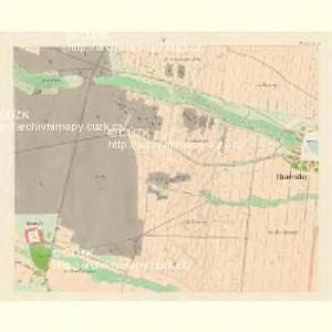
Hradezko (Hradecko) - c2290-1-005 - Kaiserpflichtexemplar der Landkarten des stabilen Katasters
1 : 2880
Hradezko (Hradecko) - c2290-1-006 - Kaiserpflichtexemplar der Landkarten des stabilen Katasters
1 : 2880
Hradezko (Hradecko) - c2290-1-004 - Kaiserpflichtexemplar der Landkarten des stabilen Katasters
1 : 2880
Hradezko (Hradecko) - c2290-1-002 - Kaiserpflichtexemplar der Landkarten des stabilen Katasters
1 : 2880
Hradezko (Hradecko) - c2290-1-001 - Kaiserpflichtexemplar der Landkarten des stabilen Katasters
1 : 2880
Hradezko (Hradecko) - c2290-1-003 - Kaiserpflichtexemplar der Landkarten des stabilen Katasters
1 : 2880
Mapa dvora Hubenov v katastrální obci Hradecko
1 : 5760
Katastrální mapa obce Hradecko WC-VII-17 be ce
1 : 2880
Katastrální mapa obce Sedlec WC-VII- 17 be
1 : 2880
Katastrální mapa obce Kralovice s osadou Týnice WC-VI-17 df VII-17 cg
1 : 2880
Hochlibin - c8947-1-003 - Kaiserpflichtexemplar der Landkarten des stabilen Katasters
1 : 2880
Hochlibin - c8947-1-001 - Kaiserpflichtexemplar der Landkarten des stabilen Katasters
1 : 2880
Hochlibin - c8947-1-005 - Kaiserpflichtexemplar der Landkarten des stabilen Katasters
1 : 2880
Hochlibin - c8947-1-004 - Kaiserpflichtexemplar der Landkarten des stabilen Katasters
1 : 2880
Hochlibin - c8947-1-007 - Kaiserpflichtexemplar der Landkarten des stabilen Katasters
1 : 2880
Hochlibin - c8947-1-006 - Kaiserpflichtexemplar der Landkarten des stabilen Katasters
1 : 2880
Hochlibin - c8947-1-002 - Kaiserpflichtexemplar der Landkarten des stabilen Katasters
1 : 2880
Strachowitz (Strachowic) - c7372-1-001 - Kaiserpflichtexemplar der Landkarten des stabilen Katasters
1 : 2880
Strachowitz (Strachowic) - c7372-1-003 - Kaiserpflichtexemplar der Landkarten des stabilen Katasters
1 : 2880
Strachowitz (Strachowic) - c7372-1-002 - Kaiserpflichtexemplar der Landkarten des stabilen Katasters
1 : 2880

Kralowitz (Kralowice) - c3494-1-006 - Kaiserpflichtexemplar der Landkarten des stabilen Katasters
1 : 2880
Kralowitz (Kralowice) - c3494-1-009 - Kaiserpflichtexemplar der Landkarten des stabilen Katasters
1 : 2880
Kralowitz (Kralowice) - c3494-1-007 - Kaiserpflichtexemplar der Landkarten des stabilen Katasters
1 : 2880
Kralowitz (Kralowice) - c3494-1-008 - Kaiserpflichtexemplar der Landkarten des stabilen Katasters
1 : 2880
Kralowitz (Kralowice) - c3494-1-002 - Kaiserpflichtexemplar der Landkarten des stabilen Katasters
1 : 2880
Kralowitz (Kralowice) - c3494-1-003 - Kaiserpflichtexemplar der Landkarten des stabilen Katasters
1 : 2880
Kralowitz (Kralowice) - c3494-1-001 - Kaiserpflichtexemplar der Landkarten des stabilen Katasters
1 : 2880
Kralowitz (Kralowice) - c3494-1-005 - Kaiserpflichtexemplar der Landkarten des stabilen Katasters
1 : 2880