Maps of Ostrovec

Ober Wostrowetz - c2114-1-002 - Kaiserpflichtexemplar der Landkarten des stabilen Katasters
1 : 2880
Ober Wostrowetz - c2114-1-004 - Kaiserpflichtexemplar der Landkarten des stabilen Katasters
1 : 2880
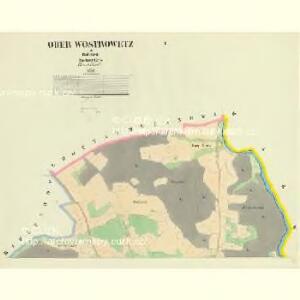
Ober Wostrowetz - c2114-1-001 - Kaiserpflichtexemplar der Landkarten des stabilen Katasters
1 : 2880
Ober Wostrowetz - c2114-1-003 - Kaiserpflichtexemplar der Landkarten des stabilen Katasters
1 : 2880
Varvažov s Pasekou a U mostu, okr. Písek, list 4 list 4
1 : 2880
Varvažov s Pasekou a U mostu, okr. Písek, list 3 list 3
1 : 2880
Warwaschau - c8333-1-004 - Kaiserpflichtexemplar der Landkarten des stabilen Katasters
1 : 2880
Warwaschau - c8333-1-005 - Kaiserpflichtexemplar der Landkarten des stabilen Katasters
1 : 2880
Warwaschau - c8333-1-003 - Kaiserpflichtexemplar der Landkarten des stabilen Katasters
1 : 2880
Warwaschau - c8333-1-001 - Kaiserpflichtexemplar der Landkarten des stabilen Katasters
1 : 2880
Warwaschau - c8333-1-002 - Kaiserpflichtexemplar der Landkarten des stabilen Katasters
1 : 2880
Warwaschau - c8333-1-007 - Kaiserpflichtexemplar der Landkarten des stabilen Katasters
1 : 2880
Warwaschau - c8333-1-006 - Kaiserpflichtexemplar der Landkarten des stabilen Katasters
1 : 2880
Unter Wostrowec - c1356-1-002 - Kaiserpflichtexemplar der Landkarten des stabilen Katasters
1 : 2880
Unter Wostrowec - c1356-1-003 - Kaiserpflichtexemplar der Landkarten des stabilen Katasters
1 : 2880
Unter Wostrowec - c1356-1-004 - Kaiserpflichtexemplar der Landkarten des stabilen Katasters
1 : 2880
Unter Wostrowec - c1356-1-001 - Kaiserpflichtexemplar der Landkarten des stabilen Katasters
1 : 2880
Soubor katastrálních map obcí ležících na území velkostatku orlického s přivtělenými statky, s vyznačením příslušné tratě státní dráhy (polohorysy tratí), list 27 list 27
1 : 2880
Varvažov s Pasekou a U mostu, okr. Písek, list 5 list 5
1 : 2880
Smetanova Lhota s Karlovem, Vrábskem a U mostu varvažovského, list 5 1

Smetanova Lhota s Karlovem, Vrábskem a U mostu varvažovského, list 8 1

Plán rozdělení revírů Novodvorského a Žbonínského na hájetiny 1

Mapa porostů revírů Vrábsko a Žbonin
Vrábsko (Smetanova Lhota, Česko) Müller, B.
Přehledná mapa velkostatku Orlíka, Čimelic, Varvažova, Tochovic a přivtělených statků Bukovan, Zalužan a Zbenic podle majetkového stavu z r. 1913, list 12 1
1 : 25000
Lhotta Smetanowa - c7063-1-004 - Kaiserpflichtexemplar der Landkarten des stabilen Katasters
1 : 2880
Lhotta Smetanowa - c7063-1-007 - Kaiserpflichtexemplar der Landkarten des stabilen Katasters
1 : 2880
Lhotta Smetanowa - c7063-1-003 - Kaiserpflichtexemplar der Landkarten des stabilen Katasters
1 : 2880
Lhotta Smetanowa - c7063-1-002 - Kaiserpflichtexemplar der Landkarten des stabilen Katasters
1 : 2880
Lhotta Smetanowa - c7063-1-005 - Kaiserpflichtexemplar der Landkarten des stabilen Katasters
1 : 2880
Lhotta Smetanowa - c7063-1-001 - Kaiserpflichtexemplar der Landkarten des stabilen Katasters
1 : 2880