Maps of Slapy

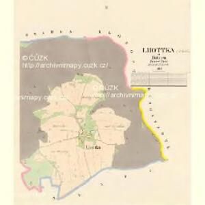
Lhottka - c1917-1-001 - Kaiserpflichtexemplar der Landkarten des stabilen Katasters
1 : 2880
Lhottka - c1917-1-002 - Kaiserpflichtexemplar der Landkarten des stabilen Katasters
1 : 2880
[Tábor a nejbližší okolí]
1 : 60000 Tábor-oblast (Česko)
Dražižka - c1519-1-004 - Kaiserpflichtexemplar der Landkarten des stabilen Katasters
1 : 2880
Dražižka - c1519-1-002 - Kaiserpflichtexemplar der Landkarten des stabilen Katasters
1 : 2880
Dražižka - c1519-1-003 - Kaiserpflichtexemplar der Landkarten des stabilen Katasters
1 : 2880
Dražižka - c1519-1-001 - Kaiserpflichtexemplar der Landkarten des stabilen Katasters
1 : 2880
Situationskarte der zu St. Dreifaltigkeits-Silber-Zeche in Horky gehörigen Taggebäude
1 : 430 Horky (Tábor, Česko) Storch, Jaroslav K.k. Hochdruckerei v. Gottlieb Haase Sohne
Slapp - c6998-1-001 - Kaiserpflichtexemplar der Landkarten des stabilen Katasters
1 : 2880
Slapp - c6998-1-002 - Kaiserpflichtexemplar der Landkarten des stabilen Katasters
1 : 2880
Slapp - c6998-1-003 - Kaiserpflichtexemplar der Landkarten des stabilen Katasters
1 : 2880
Klokott - c3179-1-002 - Kaiserpflichtexemplar der Landkarten des stabilen Katasters
1 : 2880
Klokott - c3179-1-004 - Kaiserpflichtexemplar der Landkarten des stabilen Katasters
1 : 2880
Klokott - c3179-1-003 - Kaiserpflichtexemplar der Landkarten des stabilen Katasters
1 : 2880
Klokott - c3179-1-001 - Kaiserpflichtexemplar der Landkarten des stabilen Katasters
1 : 2880
Bergstadtl - c2006-1-002 - Kaiserpflichtexemplar der Landkarten des stabilen Katasters
1 : 2880
Bergstadtl - c2006-1-001 - Kaiserpflichtexemplar der Landkarten des stabilen Katasters
1 : 2880
Ohraženice u řeky Lužnice blíž Klokot a Zahrádky
1 : 5400 Klokoty (Tábor, Česko)
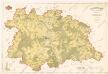
Tabor
1 : 25000 Protektorát Čechy a Morava Landesvermessungsamt Böhmen u. Mähren
Tabor u. Umgebung
1 : 25000 Protektorát Čechy a Morava Landesvermessungsamt Böhmen u. Mähren
Gradkartenblatt
1 : 25000 Tábor-oblast (Česko) Gravisi, Karl von
III. vojenské mapování 4253/2
1 : 25000
III. vojenské mapování 4253/2
1 : 25000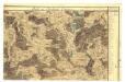


Polohopisná mapa silnic, cest a obecního majetku Táborského
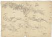
[Tábor a okolí]
Soběslav (Česko)
Podrobné mapy zemí Koruny české v měřítku 1:75.000 a mapa vzdáleností všech míst při silnici ležících - Tábor - Milevsko - Sedlec. Průvodce statisticko-historický po všech místech na těchto mapách uvedených a rejstřík věcný názvů hor, potoků, řek, rybníků atd. Sešit 44. List 58,
1 : 75000
Podrobné mapy zemí Koruny české v měřítku 1:75.000 a mapy vzdáleností všech míst při silnici ležících
1 : 75000 Milevsko (Česko : oblast) Bělohlav, Josef F. Topič