Maps of Tchořovice

Hajan - c1749-1-003 - Kaiserpflichtexemplar der Landkarten des stabilen Katasters
1 : 2880
Hajan - c1749-1-001 - Kaiserpflichtexemplar der Landkarten des stabilen Katasters
1 : 2880
Hajan - c1749-1-002 - Kaiserpflichtexemplar der Landkarten des stabilen Katasters
1 : 2880
Thorowitz - c7903-1-006 - Kaiserpflichtexemplar der Landkarten des stabilen Katasters
1 : 2880
Thorowitz - c7903-1-001 - Kaiserpflichtexemplar der Landkarten des stabilen Katasters
1 : 2880
Thorowitz - c7903-1-005 - Kaiserpflichtexemplar der Landkarten des stabilen Katasters
1 : 2880
Thorowitz - c7903-1-004 - Kaiserpflichtexemplar der Landkarten des stabilen Katasters
1 : 2880
Thorowitz - c7903-1-007 - Kaiserpflichtexemplar der Landkarten des stabilen Katasters
1 : 2880
Thorowitz - c7903-1-002 - Kaiserpflichtexemplar der Landkarten des stabilen Katasters
1 : 2880
Thorowitz - c7903-1-003 - Kaiserpflichtexemplar der Landkarten des stabilen Katasters
1 : 2880
Chlum - c2502-1-001 - Kaiserpflichtexemplar der Landkarten des stabilen Katasters
1 : 2880
Chlum - c2502-1-004 - Kaiserpflichtexemplar der Landkarten des stabilen Katasters
1 : 2880
Chlum - c2502-1-003 - Kaiserpflichtexemplar der Landkarten des stabilen Katasters
1 : 2880
Chlum - c2502-1-002 - Kaiserpflichtexemplar der Landkarten des stabilen Katasters
1 : 2880
Kotzelowitz - c3231-1-001 - Kaiserpflichtexemplar der Landkarten des stabilen Katasters
1 : 2880
Blattna (Blatna) - c0268-1-008 - Kaiserpflichtexemplar der Landkarten des stabilen Katasters
1 : 2880
Blattna (Blatna) - c0268-1-002 - Kaiserpflichtexemplar der Landkarten des stabilen Katasters
1 : 2880
Blattna (Blatna) - c0268-1-006 - Kaiserpflichtexemplar der Landkarten des stabilen Katasters
1 : 2880
Blattna (Blatna) - c0268-1-004 - Kaiserpflichtexemplar der Landkarten des stabilen Katasters
1 : 2880
Blattna (Blatna) - c0268-1-001 - Kaiserpflichtexemplar der Landkarten des stabilen Katasters
1 : 2880
Blattna (Blatna) - c0268-1-005 - Kaiserpflichtexemplar der Landkarten des stabilen Katasters
1 : 2880
Blattna (Blatna) - c0268-1-003 - Kaiserpflichtexemplar der Landkarten des stabilen Katasters
1 : 2880
Blattna (Blatna) - c0268-1-007 - Kaiserpflichtexemplar der Landkarten des stabilen Katasters
1 : 2880
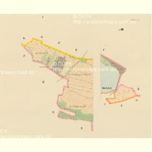
Závěšín
1 : 10000 Závišín (Bělčice, Strakonice, Česko)

Mapa okresu Blatenského
1 : 80000 Blatná-oblast (Strakonice, Česko) Rollinger, Jos. Neudörfl, Josef Věnceslav J.V. Neudörfl
Podrobné mapy zemí Koruny české v měřítku 1:75.000 a mapa vzdáleností všech míst při silnici ležících - Blovice - Nepomuk - Blatná. Průvodce statisticko-historický po všech místech na těchto mapách uvedených a rejstřík věcný názvů hor, potoků, řek, rybníků atd. Sešit 42. List 32,
1 : 75000
Podrobná mapa Království českého
1 : 100000 Blatná (Strakonice, Česko : oblast) Srp, Jan Jaroslav Bursík
Vilímkovy místopisné mapy zemí Koruny české
1 : 100000 Blatná (Strakonice, Česko) Srp, Jan Jos. R. Vilímek