Maps of Mařenice

Nieder Lichtenwalde - c1394-2-003 - Kaiserpflichtexemplar der Landkarten des stabilen Katasters
1 : 2880
Nieder Lichtenwalde - c1394-2-002 - Kaiserpflichtexemplar der Landkarten des stabilen Katasters
1 : 2880
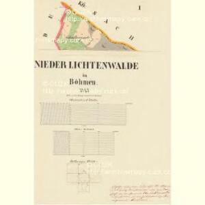
Nieder Lichtenwalde - c1394-2-001 - Kaiserpflichtexemplar der Landkarten des stabilen Katasters
1 : 2880
Krombach - c3565-1-004 - Kaiserpflichtexemplar der Landkarten des stabilen Katasters
1 : 2880
Krombach - c3565-1-005 - Kaiserpflichtexemplar der Landkarten des stabilen Katasters
1 : 2880
Krombach - c3565-1-001 - Kaiserpflichtexemplar der Landkarten des stabilen Katasters
1 : 2880
Krombach - c3565-1-003 - Kaiserpflichtexemplar der Landkarten des stabilen Katasters
1 : 2880
Krombach - c3565-1-002 - Kaiserpflichtexemplar der Landkarten des stabilen Katasters
1 : 2880
Ober Lichtenwalde - c2159-2-004 - Kaiserpflichtexemplar der Landkarten des stabilen Katasters
1 : 2880
Ober Lichtenwalde - c2159-2-006 - Kaiserpflichtexemplar der Landkarten des stabilen Katasters
1 : 2880
Ober Lichtenwalde - c2159-2-001 - Kaiserpflichtexemplar der Landkarten des stabilen Katasters
1 : 2880
Ober Lichtenwalde - c2159-2-005 - Kaiserpflichtexemplar der Landkarten des stabilen Katasters
1 : 2880
Ober Lichtenwalde - c2159-2-007 - Kaiserpflichtexemplar der Landkarten des stabilen Katasters
1 : 2880
Ober Lichtenwalde - c2159-2-008 - Kaiserpflichtexemplar der Landkarten des stabilen Katasters
1 : 2880
Ober Lichtenwalde - c2159-2-003 - Kaiserpflichtexemplar der Landkarten des stabilen Katasters
1 : 2880
Ober Lichtenwalde - c2159-2-002 - Kaiserpflichtexemplar der Landkarten des stabilen Katasters
1 : 2880
Wanderkarte Zittauer Gebirge

[Kartenblatt]
1 : 25000 Cvikov (Česko : oblast) Reichsamt für Landesaufnahme
III. vojenské mapování 3653/4
1 : 25000
III. vojenské mapování 3653/4
1 : 25000
III. vojenské mapování 3653/4
1 : 25000
III. vojenské mapování 3653/4
1 : 25000
Das böhmisch-sächsische Grenzgebirge
Lužická Nisa-oblast lith. Kunstanstalt von Ed. Strache
Varnsdorf
1 : 75000 Cvikov (Česko : oblast) Vojenský zeměpisný ústav
Rumburg und Warnsdorf
1 : 75000 Rumburk (Česko : oblast) Lampe K. u. k. militär-geographisches Institut
Rumburg und Warnsdorf
1 : 75000 Rumburk (Česko : oblast) Lampe K. u. k. Militärgeographisches Institut
Rumburg und Warnsdorf
1 : 75000 Rumburk (Česko : oblast) K. u. k. Militärgeographisches Institut
III. vojenské mapování 3653
1 : 75000