Maps of Lhenice

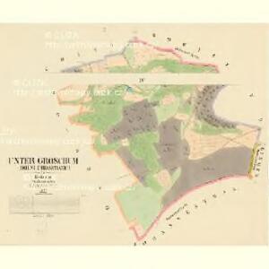
Unter Groschum (Dolni-Chrasstianki) - c1297-1-002 - Kaiserpflichtexemplar der Landkarten des stabilen Katasters
1 : 2880
Unter Groschum (Dolni-Chrasstianki) - c1297-1-001 - Kaiserpflichtexemplar der Landkarten des stabilen Katasters
1 : 2880
Ober Groschum (Horni Chrasstiankj) - c2053-1-003 - Kaiserpflichtexemplar der Landkarten des stabilen Katasters
1 : 2880
Ober Groschum (Horni Chrasstiankj) - c2053-1-001 - Kaiserpflichtexemplar der Landkarten des stabilen Katasters
1 : 2880
Ober Groschum (Horni Chrasstiankj) - c2053-1-002 - Kaiserpflichtexemplar der Landkarten des stabilen Katasters
1 : 2880
Luschitz (Lužic) - c4334-1-002 - Kaiserpflichtexemplar der Landkarten des stabilen Katasters
1 : 2880
Luschitz (Lužic) - c4334-1-001 - Kaiserpflichtexemplar der Landkarten des stabilen Katasters
1 : 2880
Kollowitz (Chwalowitz) - c2698-1-001 - Kaiserpflichtexemplar der Landkarten des stabilen Katasters
1 : 2880
Kollowitz (Chwalowitz) - c2698-1-002 - Kaiserpflichtexemplar der Landkarten des stabilen Katasters
1 : 2880
Kollowitz (Chwalowitz) - c2698-1-003 - Kaiserpflichtexemplar der Landkarten des stabilen Katasters
1 : 2880
Linden - c4095-1-002 - Kaiserpflichtexemplar der Landkarten des stabilen Katasters
1 : 2880
Linden - c4095-1-005 - Kaiserpflichtexemplar der Landkarten des stabilen Katasters
1 : 2880
Linden - c4095-1-006 - Kaiserpflichtexemplar der Landkarten des stabilen Katasters
1 : 2880
Linden - c4095-1-003 - Kaiserpflichtexemplar der Landkarten des stabilen Katasters
1 : 2880
Linden - c4095-1-001 - Kaiserpflichtexemplar der Landkarten des stabilen Katasters
1 : 2880
Linden - c4095-1-004 - Kaiserpflichtexemplar der Landkarten des stabilen Katasters
1 : 2880
Bowitz (Babitze) - c0045-1-002 - Kaiserpflichtexemplar der Landkarten des stabilen Katasters
1 : 2880
Bowitz (Babitze) - c0045-1-003 - Kaiserpflichtexemplar der Landkarten des stabilen Katasters
1 : 2880
Bowitz (Babitze) - c0045-1-001 - Kaiserpflichtexemplar der Landkarten des stabilen Katasters
1 : 2880
Topographische Karte der in Böhmen budweiser Kreises liegenden

Topographische Karte ... Herrschaft Krummau ...


Prachatice a okolí
1 : 75000 Prachatice (Česko : oblast) Vojenský zeměpisný ústav
Prachatice
1 : 75000 Prachatice (Česko : oblast) Vojenský zeměpisný ústav
Soubor přehledných map pro plánování a statistiku: 4352 – Prachatice

Protiwin und Prachatitz
1 : 75000 Prachatice (Česko : oblast) K. u. k. Militärgeographisches Institut
Podrobná mapa království Českého: Prachatice – Volary - Hor. Planá

Protiwin und Prachatitz.
from Spezialkarte der osterreichisch-ungarischen Monarchie.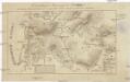
Darstellung des Ursprungs der Moldau
1 : 75000 Prácheňsko (Česko)