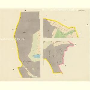
Maps of Dobřenice

Dobrzenitz (Dobřenice) - c1208-1-005 - Kaiserpflichtexemplar der Landkarten des stabilen Katasters
1 : 2880
Dobrzenitz (Dobřenice) - c1208-1-001 - Kaiserpflichtexemplar der Landkarten des stabilen Katasters
1 : 2880
Dobrzenitz (Dobřenice) - c1208-1-002 - Kaiserpflichtexemplar der Landkarten des stabilen Katasters
1 : 2880
Dobrzenitz (Dobřenice) - c1208-1-004 - Kaiserpflichtexemplar der Landkarten des stabilen Katasters
1 : 2880
Dobrzenitz (Dobřenice) - c1208-1-003 - Kaiserpflichtexemplar der Landkarten des stabilen Katasters
1 : 2880
Porostní mapa revíru Kasalice Sekce IV.
1 : 2880
Indikační skica mapy stabilního katastru pro obec Právy II., IV
1 : 2880
Indikační skica mapy stabilního katastru pro obec Právy I.
1 : 2880
Indikační skica mapy stabilního katastru pro obec Roudnice I.-IX.
1 : 2880
Kratenau (Kratonohy) - c3539-1-008 - Kaiserpflichtexemplar der Landkarten des stabilen Katasters
1 : 2880
Kratenau (Kratonohy) - c3539-1-001 - Kaiserpflichtexemplar der Landkarten des stabilen Katasters
1 : 2880
Kratenau (Kratonohy) - c3539-1-005 - Kaiserpflichtexemplar der Landkarten des stabilen Katasters
1 : 2880
Kratenau (Kratonohy) - c3539-1-003 - Kaiserpflichtexemplar der Landkarten des stabilen Katasters
1 : 2880
Kratenau (Kratonohy) - c3539-1-006 - Kaiserpflichtexemplar der Landkarten des stabilen Katasters
1 : 2880
Kratenau (Kratonohy) - c3539-1-004 - Kaiserpflichtexemplar der Landkarten des stabilen Katasters
1 : 2880
Kratenau (Kratonohy) - c3539-1-002 - Kaiserpflichtexemplar der Landkarten des stabilen Katasters
1 : 2880
Kratenau (Kratonohy) - c3539-1-007 - Kaiserpflichtexemplar der Landkarten des stabilen Katasters
1 : 2880
Mapa revíru Kasalice
1 : 10000
Porostní mapa revíru Kasalice
1 : 10000
Indikační skica mapy stabilního katastru pro obec Právy I.-IV.
1 : 2880
Praw - c6094-1-003 - Kaiserpflichtexemplar der Landkarten des stabilen Katasters
1 : 2880
Praw - c6094-1-001 - Kaiserpflichtexemplar der Landkarten des stabilen Katasters
1 : 2880
Praw - c6094-1-002 - Kaiserpflichtexemplar der Landkarten des stabilen Katasters
1 : 2880
Wositschek - c5535-1-001 - Kaiserpflichtexemplar der Landkarten des stabilen Katasters
1 : 2880
Wositschek - c5535-1-002 - Kaiserpflichtexemplar der Landkarten des stabilen Katasters
1 : 2880
Wositschek - c5535-1-003 - Kaiserpflichtexemplar der Landkarten des stabilen Katasters
1 : 2880
Indikační skica mapy stabilního katastru pro obec Osičky II.
1 : 2880
Rohozdnitz - c6509-1-001 - Kaiserpflichtexemplar der Landkarten des stabilen Katasters
1 : 2880
Rohozdnitz - c6509-1-002 - Kaiserpflichtexemplar der Landkarten des stabilen Katasters
1 : 2880