Maps of Horní Stropnice

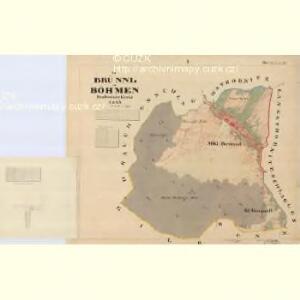
Brünnl - c1169-1-001 - Kaiserpflichtexemplar der Landkarten des stabilen Katasters
1 : 2880
Heilbeunn - c1948-1-002 - Kaiserpflichtexemplar der Landkarten des stabilen Katasters
1 : 2880
Heilbeunn - c1948-1-004 - Kaiserpflichtexemplar der Landkarten des stabilen Katasters
1 : 2880
Heilbeunn - c1948-1-001 - Kaiserpflichtexemplar der Landkarten des stabilen Katasters
1 : 2880
Heilbeunn - c1948-1-003 - Kaiserpflichtexemplar der Landkarten des stabilen Katasters
1 : 2880
Rauchenschlag - c4568-3-004 - Kaiserpflichtexemplar der Landkarten des stabilen Katasters
1 : 2880
Rauchenschlag - c4568-3-005 - Kaiserpflichtexemplar der Landkarten des stabilen Katasters
1 : 2880
Rauchenschlag - c4568-3-006 - Kaiserpflichtexemplar der Landkarten des stabilen Katasters
1 : 2880
Rauchenschlag - c4568-3-002 - Kaiserpflichtexemplar der Landkarten des stabilen Katasters
1 : 2880
Rauchenschlag - c4568-3-003 - Kaiserpflichtexemplar der Landkarten des stabilen Katasters
1 : 2880
Rauchenschlag - c4568-3-001 - Kaiserpflichtexemplar der Landkarten des stabilen Katasters
1 : 2880
[Gradkartenblatt]
1 : 25000 Benešov nad Černou (Česko : oblast) Kartographisches Institut

III. vojenské mapování 4553/2
1 : 25000
Podrobné mapy zemí Koruny české v měřítku 1:75.000 a mapa vzdáleností všech míst při silnici ležících - Kaplice - Rožmberk. Průvodce statisticko-historický po všech místech na těchto mapách uvedených a rejstřík věcný názvů hor, potoků, řek, rybníků atd. Sešit 36. List 62,
1 : 75000
II. vojenské mapování 35
1 : 144000
Podrobné mapy zemí Koruny české v měřítku 1:75.000 a mapa vzdáleností všech míst při silnici ležících - Kaplice - Rožmberk. Průvodce statisticko-historický po všech místech na těchto mapách uvedených a rejstřík věcný názvů hor, potoků, řek, rybníků atd. Sešit 36. List 62,
1 : 75000
Territorium studiorum naturalium Leopoldi Kirchner
Kaplice-oblast (Český Krumlov, Česko) Kirchner, Leopold
Kaplice a okolí
1 : 75000 Kaplice (Český Krumlov, Česko : oblast) Vojenský zeměpisný ústav
III. vojenské mapování 4553
1 : 75000
Kaplice
1 : 75000 Freistadt (Rakousko : oblast) Vojenský zeměpisný ústav
Kaplitz und Freistadt
1 : 75000 Freistadt (Rakousko : oblast) K. u. k. Militärgeographisches Institut
Übersichts-Karte der Herrschaft Gratzen in Böhmen Budweiser Kreis
1 : 115200 Nové Hrady-oblast (České Budějovice, Česko) Verlag des böhm. Forstvereins
Topographische Karte der Herrschaft Gratzen in Böhmen
1 : 58800 Nové Hrady-oblast (České Budějovice, Česko) Rowland, William Buquoy, Jiří František August
Přehledná mapa panství Nové Hrady 1

Podrobná mapa Království českého, Markrabství moravského a Vévodství slezského
1 : 100000 Kaplice (Český Krumlov, Česko : oblast) Srp, Jan Jos. R. Vilímek
Podrobná mapa Království českého
1 : 100000 Kaplice (Český Krumlov, Česko : oblast) Srp, Jan Jaroslav Bursík
Karte des Gemeindegrenzen
Karte des Bezirkes Kaplitz
1 : 150000 Kaplice-oblast (Český Krumlov, Česko) A. Haase