Maps of Deštnice

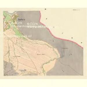
Teschnitz - c1093-1-001 - Kaiserpflichtexemplar der Landkarten des stabilen Katasters
1 : 2880
Teschnitz - c1093-1-003 - Kaiserpflichtexemplar der Landkarten des stabilen Katasters
1 : 2880
Teschnitz - c1093-1-002 - Kaiserpflichtexemplar der Landkarten des stabilen Katasters
1 : 2880
Teschnitz - c1093-1-005 - Kaiserpflichtexemplar der Landkarten des stabilen Katasters
1 : 2880
Teschnitz - c1093-1-004 - Kaiserpflichtexemplar der Landkarten des stabilen Katasters
1 : 2880
Hraniční mapa lesních parcel v katastru obce Nečemice, list 1 1
1 : 2880
Hospodářská mapa polesí Rovina, list 5 1

Terénní a půdní mapa pro exkurzi Českého lesnického spolku do domoušického lesního okrsku v roce 1881 - výřez 1
1 : 30000
Terénní a půdní mapa pro exkurzi Českého lesnického spolku do domoušického lesního okrsku v roce 1881 - výřez 1
1 : 30000
Netschenitz (Netschinitz) - c4986-1-005 - Kaiserpflichtexemplar der Landkarten des stabilen Katasters
1 : 2880
Netschenitz (Netschinitz) - c4986-1-002 - Kaiserpflichtexemplar der Landkarten des stabilen Katasters
1 : 2880
Netschenitz (Netschinitz) - c4986-1-003 - Kaiserpflichtexemplar der Landkarten des stabilen Katasters
1 : 2880
Netschenitz (Netschinitz) - c4986-1-001 - Kaiserpflichtexemplar der Landkarten des stabilen Katasters
1 : 2880
Netschenitz (Netschinitz) - c4986-1-006 - Kaiserpflichtexemplar der Landkarten des stabilen Katasters
1 : 2880
Netschenitz (Netschinitz) - c4986-1-004 - Kaiserpflichtexemplar der Landkarten des stabilen Katasters
1 : 2880
Satkau - c6734-1-004 - Kaiserpflichtexemplar der Landkarten des stabilen Katasters
1 : 2880
Satkau - c6734-1-003 - Kaiserpflichtexemplar der Landkarten des stabilen Katasters
1 : 2880
Satkau - c6734-1-005 - Kaiserpflichtexemplar der Landkarten des stabilen Katasters
1 : 2880
Satkau - c6734-1-002 - Kaiserpflichtexemplar der Landkarten des stabilen Katasters
1 : 2880
Satkau - c6734-1-001 - Kaiserpflichtexemplar der Landkarten des stabilen Katasters
1 : 2880
Kopie katastrální mapy obce Kounov, list VI 1

Kopie katastrální mapy obce Nečemice z roku 1843, list IV 1

III. vojenské mapování 3951/2
1 : 25000
Gradkartenblatt
1 : 25000 Čechy (Česko) Bulla, Eduard
[Kartenblatt]
1 : 25000 Domoušice (Česko) Reichsamt für Landesaufnahme
Porostní mapa polesí Rovina 1
1 : 10000
Kopie katastrální mapy obce Kounov, list II 1

Mapa polesí Třeboc, Obora, Přerubenice se zakreslením cest, lesů a hranic schwarzenberských a cizích polesí 1