Maps of Český Jiřetín

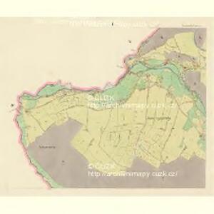
Georgensdorf - c0989-1-001 - Kaiserpflichtexemplar der Landkarten des stabilen Katasters
1 : 2880
Georgensdorf - c0989-1-005 - Kaiserpflichtexemplar der Landkarten des stabilen Katasters
1 : 2880
Georgensdorf - c0989-1-007 - Kaiserpflichtexemplar der Landkarten des stabilen Katasters
1 : 2880
Georgensdorf - c0989-1-003 - Kaiserpflichtexemplar der Landkarten des stabilen Katasters
1 : 2880
Georgensdorf - c0989-1-002 - Kaiserpflichtexemplar der Landkarten des stabilen Katasters
1 : 2880
Georgensdorf - c0989-1-006 - Kaiserpflichtexemplar der Landkarten des stabilen Katasters
1 : 2880
Georgensdorf - c0989-1-004 - Kaiserpflichtexemplar der Landkarten des stabilen Katasters
1 : 2880
Fleyh - c1668-1-008 - Kaiserpflichtexemplar der Landkarten des stabilen Katasters
1 : 2880
Fleyh - c1668-1-003 - Kaiserpflichtexemplar der Landkarten des stabilen Katasters
1 : 2880
Fleyh - c1668-1-007 - Kaiserpflichtexemplar der Landkarten des stabilen Katasters
1 : 2880
Fleyh - c1668-1-004 - Kaiserpflichtexemplar der Landkarten des stabilen Katasters
1 : 2880
Fleyh - c1668-1-006 - Kaiserpflichtexemplar der Landkarten des stabilen Katasters
1 : 2880
Fleyh - c1668-1-011 - Kaiserpflichtexemplar der Landkarten des stabilen Katasters
1 : 2880
Fleyh - c1668-1-009 - Kaiserpflichtexemplar der Landkarten des stabilen Katasters
1 : 2880
Fleyh - c1668-1-002 - Kaiserpflichtexemplar der Landkarten des stabilen Katasters
1 : 2880
Fleyh - c1668-1-010 - Kaiserpflichtexemplar der Landkarten des stabilen Katasters
1 : 2880
Fleyh - c1668-1-001 - Kaiserpflichtexemplar der Landkarten des stabilen Katasters
1 : 2880
Fleyh - c1668-1-005 - Kaiserpflichtexemplar der Landkarten des stabilen Katasters
1 : 2880
[Kartenblatt]
1 : 25000 Krušné hory (Česko a Německo) Reichsamt für Landesaufnahme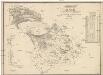
Karte des Bezirkes Dux
1 : 36000 Duchcov-oblast (Česko) Hollmann, Victor Josef Mecséry de Tsóor, Karl Johann Friedrich Selner
III. vojenské mapování 3751/1
1 : 25000
III. vojenské mapování 3751/1
1 : 25000
III. vojenské mapování 3751/1
1 : 25000
Meßtischblatt 131 : Neuwernsdorf, 1938
1 : 250000 Neuwernsdorf. - Umdr.-Ausg., aufgen. 1910, hrsg. 1911, bericht. 1923. - 1:25000. - Leipzig, 1938. - 1 Kt.
Meßtischblatt 131 : Neuwernsdorf, 1920
1 : 250000 Neuwernsdorf. - Aufgen. 1910. - 1:25000. - Leipzig, 1920. - 1 Kt.
Meßtischblatt 131 : Neuwernsdorf, 1919
1 : 250000 Neuwernsdorf. - Aufgen. 1910. - 1:25000. - Leipzig, 1919. - 1 Kt.

Meßtischblatt 5247 : Nassau, 1942
1 : 250000 Nassau. - Aufn. 1910, hrsg. 1912, bericht. Sachsen 1936, S. - 1:25000. - Leipzig, 1942. - 1 Kt.
Meßtischblatt 5247 : Nassau, 1938
1 : 250000 Nassau. - Umdr.-Ausg., aufgen. 1910, hrsg. 1912, außersächs. Teil 1919, bericht. 1923. - 1:25000. - Leipzig, 1938. - 1 Kt.
Meßtischblatt 118 : Nassau, 1934
1 : 250000 Nassau. - Umdr.-Ausg., aufgen. 1910, hrsg. 1912, außersächs. Teil 1919, bericht. 1923. - 1:25000. - Leipzig, 1934. - 1 Kt.
Meßtischblatt 118 : Nassau, 1923
1 : 250000 Nassau. - Aufgen. 1910, hrsg. 1912, außersächs. Teil 1919, bericht. 1923. - 1:25000. - Leipzig, 1923. - 1 Kt.
Meßtischblatt 118 : Nassau, 1921
1 : 250000 Nassau. - Aufgen. 1910, hrsg. 1919, einz. Nachtr. 1921. - 1:25000. - Leipzig, 1921. - 1 Kt.
Meßtischblatt 118 : Nassau, 1919
1 : 250000 Nassau. - Aufgen. 1910. - 1:25000. - Leipzig, 1919. - 1 Kt.