Maps of Tábor

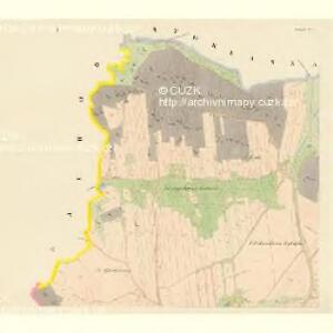
Czekanitz - c0830-1-004 - Kaiserpflichtexemplar der Landkarten des stabilen Katasters
1 : 2880
Czekanitz - c0830-1-001 - Kaiserpflichtexemplar der Landkarten des stabilen Katasters
1 : 2880
Czekanitz - c0830-1-003 - Kaiserpflichtexemplar der Landkarten des stabilen Katasters
1 : 2880
Czekanitz - c0830-1-002 - Kaiserpflichtexemplar der Landkarten des stabilen Katasters
1 : 2880
Tabor - c7820-1-002 - Kaiserpflichtexemplar der Landkarten des stabilen Katasters
1 : 2880
Tabor - c7820-1-003 - Kaiserpflichtexemplar der Landkarten des stabilen Katasters
1 : 2880
Tabor - c7820-1-001 - Kaiserpflichtexemplar der Landkarten des stabilen Katasters
1 : 2880
Situační plan [sic] statku při král. české vyšší hospodářské a hospodářsko průmyslové zemské škole v Táboře
1 : 11520 Tábor (Česko) Vyšší hospodářská a hospodářsko-průmyslová škola zemská
[Tábor, Klokoty, Náchod]
1 : 30000 Tábor Meub Pluth, C.
Stoklasna Lhotta - c7354-1-002 - Kaiserpflichtexemplar der Landkarten des stabilen Katasters
1 : 2880
Stoklasna Lhotta - c7354-1-001 - Kaiserpflichtexemplar der Landkarten des stabilen Katasters
1 : 2880
Stoklasna Lhotta - c7354-1-003 - Kaiserpflichtexemplar der Landkarten des stabilen Katasters
1 : 2880
Tabor
1 : 25000 Protektorát Čechy a Morava Landesvermessungsamt Böhmen u. Mähren
Ohraženice u řeky Lužnice blíž Klokot a Zahrádky
1 : 5400 Klokoty (Tábor, Česko)
[Tábor a nejbližší okolí]
1 : 60000 Tábor-oblast (Česko)
Situační plán statku při král. české vyšší hospodářské a hospodářsko-průmyslové zemské škole v Táboře
Klokoty (Tábor, Česko)
Tabor
1 : 25000 Chýnov (Česko : oblast) Landesvermessungsamt Böhmen u. Mähren
Mieschitz - c4613-1-003 - Kaiserpflichtexemplar der Landkarten des stabilen Katasters
1 : 2880
Mieschitz - c4613-1-002 - Kaiserpflichtexemplar der Landkarten des stabilen Katasters
1 : 2880
Mieschitz - c4613-1-004 - Kaiserpflichtexemplar der Landkarten des stabilen Katasters
1 : 2880
Mieschitz - c4613-1-001 - Kaiserpflichtexemplar der Landkarten des stabilen Katasters
1 : 2880
Mieschitz - c4613-1-005 - Kaiserpflichtexemplar der Landkarten des stabilen Katasters
1 : 2880
Hlinitz - c1871-1-002 - Kaiserpflichtexemplar der Landkarten des stabilen Katasters
1 : 2880
Hlinitz - c1871-1-003 - Kaiserpflichtexemplar der Landkarten des stabilen Katasters
1 : 2880
Hlinitz - c1871-1-001 - Kaiserpflichtexemplar der Landkarten des stabilen Katasters
1 : 2880
Nachod - c4951-1-001 - Kaiserpflichtexemplar der Landkarten des stabilen Katasters
1 : 2880
Nachod - c4951-1-002 - Kaiserpflichtexemplar der Landkarten des stabilen Katasters
1 : 2880
Tábor

[Tábor]
1 : 30000 Tábor (Česko) Branberger Pluth, C.