Maps of Pomezí nad Ohří

Zettendorf - c0749-1-002 - Kaiserpflichtexemplar der Landkarten des stabilen Katasters
1 : 2880
Zettendorf - c0749-1-001 - Kaiserpflichtexemplar der Landkarten des stabilen Katasters
1 : 2880
Reissig - c3153-2-002 - Kaiserpflichtexemplar der Landkarten des stabilen Katasters
1 : 2880
Reissig - c3153-2-001 - Kaiserpflichtexemplar der Landkarten des stabilen Katasters
1 : 2880
Kammerdorf - c4334-2-003 - Kaiserpflichtexemplar der Landkarten des stabilen Katasters
1 : 2880
Kammerdorf - c4334-2-001 - Kaiserpflichtexemplar der Landkarten des stabilen Katasters
1 : 2880
Kammerdorf - c4334-2-002 - Kaiserpflichtexemplar der Landkarten des stabilen Katasters
1 : 2880
Kammerdorf - c4334-2-004 - Kaiserpflichtexemplar der Landkarten des stabilen Katasters
1 : 2880
Stein - c6920-2-001 - Kaiserpflichtexemplar der Landkarten des stabilen Katasters
1 : 2880
Stein - c6920-2-002 - Kaiserpflichtexemplar der Landkarten des stabilen Katasters
1 : 2880
Liebeneck - c8108-2-002 - Kaiserpflichtexemplar der Landkarten des stabilen Katasters
1 : 2880
Liebeneck - c8108-2-001 - Kaiserpflichtexemplar der Landkarten des stabilen Katasters
1 : 2880
Pirk - c0617-2-002 - Kaiserpflichtexemplar der Landkarten des stabilen Katasters
1 : 2880
Pirk - c0617-2-001 - Kaiserpflichtexemplar der Landkarten des stabilen Katasters
1 : 2880
III. vojenské mapování 3948/4
1 : 25000
III. vojenské mapování 3948/4
1 : 25000
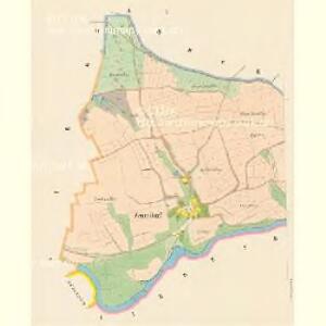
Umgebungskarte der Kurstadt Franzensbad
1 : 25000 Františkovy Lázně (Česko : oblast) E. A. Götz
Umgebungskarte der Kurstadt Franzensbad
1 : 50000 Cheb (Česko : oblast) E.A. Götz
Repraesentatio geographica circvli Egerani nec non Elnbogensis in quo simul viae Egeranae in thermas Carolinas distincta delineato conscriptur
1 : 200000 Cheb-oblast (Česko) Müller, Johann Christoph apud Homannianos Heredes
Repraesentatio Geographica Curculi Egerani nec non Elnbogensis in quo simul viae Egeranae in Thermas Carolinas distincta delineato conscriptur
1 : 200000 Cheb-oblast (Česko) Müller, Johann Christoph apud Homannianos Heredes
[Kartenblatt]
1 : 25000 Arzberg (Bavorsko, Německo) Reichsamt für Landesaufnahme


Mapy plánování ČSR

Soubor přehledných map pro plánování a statistiku: 3848 – Hranice
Franzensbrunn und Marienbad
Františkovy Lázně-oblast (Česko) Streit, Friedrich Wilhelm Müller, Leopold
Accurate geograph. Delineation des zu dem Koenigreich Boehmen gehoerigen Egerischen Creisses
1 : 130000 Cheb-oblast (Česko) Petrus Schenk
Trigonometrisches Netz als Grundlage zur Charte vom Egerlande
1 : 112000 Cheb-oblast (Česko) Kreibich, František Jakub Jindřich David, Martin Alois
Charte vom Egerischen Bezirke
1 : 115000 Cheb-oblast (Česko) Kreibich, František Jakub Jindřich Kettner, C
Podrobná mapa Království českého
1 : 100000 Aš (Česko : oblast) Srp, Jan Jos. R. Vilímek