Maps of Hroznětín

Langgrün - c0719-2-002 - Kaiserpflichtexemplar der Landkarten des stabilen Katasters
1 : 2880
Langgrün - c0719-2-003 - Kaiserpflichtexemplar der Landkarten des stabilen Katasters
1 : 2880
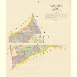
Langgrün - c0719-2-001 - Kaiserpflichtexemplar der Landkarten des stabilen Katasters
1 : 2880
Gfell - c3097-1-002 - Kaiserpflichtexemplar der Landkarten des stabilen Katasters
1 : 2880
Gfell - c3097-1-001 - Kaiserpflichtexemplar der Landkarten des stabilen Katasters
1 : 2880
Gfell - c3097-1-003 - Kaiserpflichtexemplar der Landkarten des stabilen Katasters
1 : 2880
Tiefenbach - c1895-1-001 - Kaiserpflichtexemplar der Landkarten des stabilen Katasters
1 : 2880
Tiefenbach - c1895-1-002 - Kaiserpflichtexemplar der Landkarten des stabilen Katasters
1 : 2880
Lichtenstadt - c2367-1-004 - Kaiserpflichtexemplar der Landkarten des stabilen Katasters
1 : 2880
Lichtenstadt - c2367-1-002 - Kaiserpflichtexemplar der Landkarten des stabilen Katasters
1 : 2880
Lichtenstadt - c2367-1-003 - Kaiserpflichtexemplar der Landkarten des stabilen Katasters
1 : 2880
Lichtenstadt - c2367-1-005 - Kaiserpflichtexemplar der Landkarten des stabilen Katasters
1 : 2880
Lichtenstadt - c2367-1-001 - Kaiserpflichtexemplar der Landkarten des stabilen Katasters
1 : 2880
Ullersgrün - c5423-1-002 - Kaiserpflichtexemplar der Landkarten des stabilen Katasters
1 : 2880
Ullersgrün - c5423-1-003 - Kaiserpflichtexemplar der Landkarten des stabilen Katasters
1 : 2880
Ullersgrün - c5423-1-001 - Kaiserpflichtexemplar der Landkarten des stabilen Katasters
1 : 2880
Grassengrün - c1754-2-004 - Kaiserpflichtexemplar der Landkarten des stabilen Katasters
1 : 2880
Grassengrün - c1754-2-001 - Kaiserpflichtexemplar der Landkarten des stabilen Katasters
1 : 2880
Grassengrün - c1754-2-002 - Kaiserpflichtexemplar der Landkarten des stabilen Katasters
1 : 2880
Grassengrün - c1754-2-003 - Kaiserpflichtexemplar der Landkarten des stabilen Katasters
1 : 2880
III. vojenské mapování 3850/3
1 : 25000
Gradkartenblatt
1 : 25000 Ostrov-oblast (Karlovy Vary, Česko) Bellschan, Anton
III. vojenské mapování 3850/3
1 : 25000
[Kartenblatt]
1 : 25000 Jáchymov (Karlovy Vary, Česko : oblast) Reichsamt für Landesaufnahme
Lichtenstädter Vikariat
Hroznětín (Karlovy Vary, Česko)
Morphologische Uebersichtskarte des Falkenauer Tertiärbeckens
1 : 120000 Sokolov (Česko : oblast) Peter, Josef
Kaaden und Joachimsthal
1 : 75000 Jáchymov (Karlovy Vary, Česko : oblast) Leitner K. u. k. militär-geographisches Institut
Kaaden und Joachimsthal
1 : 75000 Jáchymov (Karlovy Vary, Česko : oblast) Leitner K. u. k. Militärgeographisches Institut
Kaaden und Joachimsthal
1 : 75000 Jáchymov (Karlovy Vary, Česko : oblast) K. u. k. Militärgeographisches Institut