Maps of Bublava

Schwaderbach - c0621-2-001 - Kaiserpflichtexemplar der Landkarten des stabilen Katasters
1 : 2880
Schwaderbach - c0621-2-002 - Kaiserpflichtexemplar der Landkarten des stabilen Katasters
1 : 2880
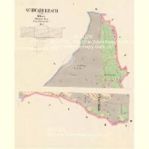
Schwaderbach - c0621-2-004 - Kaiserpflichtexemplar der Landkarten des stabilen Katasters
1 : 2880
Schwaderbach - c0621-2-003 - Kaiserpflichtexemplar der Landkarten des stabilen Katasters
1 : 2880
Schwaderbach - c0621-2-005 - Kaiserpflichtexemplar der Landkarten des stabilen Katasters
1 : 2880
Eibenberg - c7917-1-002 - Kaiserpflichtexemplar der Landkarten des stabilen Katasters
1 : 2880
Eibenberg - c7917-1-001 - Kaiserpflichtexemplar der Landkarten des stabilen Katasters
1 : 2880
III. vojenské mapování 3849/1
1 : 25000
III. vojenské mapování 3849/1
1 : 25000
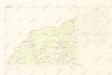
Grünberg - c9244-1-001 - Kaiserpflichtexemplar der Landkarten des stabilen Katasters
1 : 2880
Grünberg - c9244-1-002 - Kaiserpflichtexemplar der Landkarten des stabilen Katasters
1 : 2880
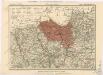
Bezirk Graslitz

Soubor přehledných map pro plánování a statistiku: 3849 – Kraslice
Mapy plánování ČSR

Podrobná mapa Království českého
1 : 100000 Hranice (Cheb, Česko : oblast) Srp, Jan Jos. R. Vilímek
Vilímkovy místopisné mapy zemí Koruny české
1 : 100000 Hranice (Cheb, Česko : oblast) Srp, Jan Jos. R. Vilímek
Müllerova mapa Čech
1 : 132000
III. vojenské mapování 3849
1 : 75000
Graslitz und Johanngeorgenstadt
1 : 75000 Johanngeorgenstadt (Německo : oblast) Höller, K. K. u. k. militär-geographisches Institut
Graslitz und Johanngeorgenstadt
1 : 75000 Johanngeorgenstadt (Německo : oblast) Höller, K. K. u. k. Militärgeographisches Institut
Graslitz und Johanngeorgenstadt
1 : 75000 Johanngeorgenstadt (Německo : oblast) K. u. k. Militärgeographisches Institut
Kraslice
1 : 75000 Kraslice-oblast (Česko) Vojenský zeměpisný ústav
Graslitz und Johanngeorgenstadt.
from Spezialkarte der osterreichisch-ungarischen Monarchie.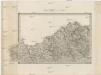
Umgebungen von Neudek
Nejdek-oblast (Karlovy Vary, Česko) Kiss, Josef K. u. k. Militärgeographisches Institut
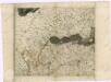
Carlsbad mit dem Gantzen Ellenbogner Creisse im Königreiche Böhmen
1 : 360000 Mollova mapová sbírka Weigel, Christoph Weigel, Christoph I. - dědici
Generalkarte der Bezirkshauptmannschaft Asch
1 : 220000 Aš (Česko) Wagner, Jan Eduard F. Kytka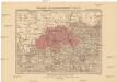
Generalkarte der Bezirkshauptmannschaft Graslitz
1 : 220000 Kraslice-oblast (Česko) Wagner, Jan Eduard F. Kytka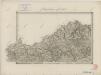
II. vojenské mapování 5
1 : 144000