Maps of Bradáčov

Bradatschow - c0450-1-002 - Kaiserpflichtexemplar der Landkarten des stabilen Katasters
1 : 2880
Bradatschow - c0450-1-001 - Kaiserpflichtexemplar der Landkarten des stabilen Katasters
1 : 2880
Ober und Unter Swietla - c2160-1-002 - Kaiserpflichtexemplar der Landkarten des stabilen Katasters
1 : 2880
Ober und Unter Swietla - c2160-1-001 - Kaiserpflichtexemplar der Landkarten des stabilen Katasters
1 : 2880
Radostowitz - c6385-1-001 - Kaiserpflichtexemplar der Landkarten des stabilen Katasters
1 : 2880
Radostowitz - c6385-1-003 - Kaiserpflichtexemplar der Landkarten des stabilen Katasters
1 : 2880
Radostowitz - c6385-1-004 - Kaiserpflichtexemplar der Landkarten des stabilen Katasters
1 : 2880
Radostowitz - c6385-1-002 - Kaiserpflichtexemplar der Landkarten des stabilen Katasters
1 : 2880
Pogbuk - c5963-1-001 - Kaiserpflichtexemplar der Landkarten des stabilen Katasters
1 : 2880
Pogbuk - c5963-1-004 - Kaiserpflichtexemplar der Landkarten des stabilen Katasters
1 : 2880
Pogbuk - c5963-1-003 - Kaiserpflichtexemplar der Landkarten des stabilen Katasters
1 : 2880
Pogbuk - c5963-1-002 - Kaiserpflichtexemplar der Landkarten des stabilen Katasters
1 : 2880
Rodna - c6493-1-001 - Kaiserpflichtexemplar der Landkarten des stabilen Katasters
1 : 2880
Rodna - c6493-1-003 - Kaiserpflichtexemplar der Landkarten des stabilen Katasters
1 : 2880
Rodna - c6493-1-002 - Kaiserpflichtexemplar der Landkarten des stabilen Katasters
1 : 2880
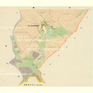
Mappa über den Herrschafftlichen na Lawiczkach und bey Chlistow genandten Wald wie solcher zu dem Domamischler Hoff vermög der Abschätzung de Anno 1692 solle zugetheilet sein worden
Domamyšl (Tábor, Česko) Willas, Heinrich Carl Merian, Matthaeus

Podrobné mapy zemí Koruny české v měřítku 1:75.000 a mapy vzdáleností všech míst při silnici ležících
1 : 75000 Mladá Vožice (Česko : oblast) Bělohlav, Josef F. Topič
Polohopisná mapa silnic, cest a obecního majetku Táborského
Podrobná místopisná mapa Království Českého

Podrobná mapa Království českého
1 : 100000 Humpolec (Pelhřimov, Česko : oblast) Srp, Jan Jaroslav Bursík
Podrobná místopisná mapa Království Českého

Politický okres Táborský
1 : 100000 Tábor-oblast (Česko) Srp, Jan Schwihlik, F. Jos. R. Vilímek
Selcan und Junc-Woschitz.
from Spezialkarte der osterreichisch-ungarischen Monarchie.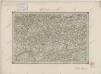
II. vojenské mapování 16
1 : 144000
Kamenitz a./d. Linde (Bohmen).
from Spezialkarte der osterreichisch-ungarischen Monarchie.
Tabor.
from Spezialkarte der osterreichisch-ungarischen Monarchie.
Ledec und Wlaschim.
from Spezialkarte der osterreichisch-ungarischen Monarchie.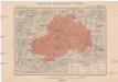
Generální mapa okresního hejtmanství Ledečského
1 : 220000 Ledeč nad Sázavou-oblast (Česko) Wagner, Jan Eduard F. Kytka