Maps of Borová

Borowa - c0386-1-006 - Kaiserpflichtexemplar der Landkarten des stabilen Katasters
1 : 2880
Borowa - c0386-1-004 - Kaiserpflichtexemplar der Landkarten des stabilen Katasters
1 : 2880
Borowa - c0386-1-002 - Kaiserpflichtexemplar der Landkarten des stabilen Katasters
1 : 2880
Borowa - c0386-1-005 - Kaiserpflichtexemplar der Landkarten des stabilen Katasters
1 : 2880
Borowa - c0386-1-003 - Kaiserpflichtexemplar der Landkarten des stabilen Katasters
1 : 2880
Borowa - c0386-1-007 - Kaiserpflichtexemplar der Landkarten des stabilen Katasters
1 : 2880
Borowa - c0386-1-001 - Kaiserpflichtexemplar der Landkarten des stabilen Katasters
1 : 2880
Náčrt mapy dominikálních pozemků osady Damašek u Pusté Kamenice
1 : 3161
Mapa polesí Lubná
1 : 5760
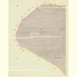
Wüst Ribny (Pusty-Rybny) - c6287-1-003 - Kaiserpflichtexemplar der Landkarten des stabilen Katasters
1 : 2880
Wüst Ribny (Pusty-Rybny) - c6287-1-006 - Kaiserpflichtexemplar der Landkarten des stabilen Katasters
1 : 2880
Wüst Ribny (Pusty-Rybny) - c6287-1-005 - Kaiserpflichtexemplar der Landkarten des stabilen Katasters
1 : 2880
Wüst Ribny (Pusty-Rybny) - c6287-1-007 - Kaiserpflichtexemplar der Landkarten des stabilen Katasters
1 : 2880
Wüst Ribny (Pusty-Rybny) - c6287-1-004 - Kaiserpflichtexemplar der Landkarten des stabilen Katasters
1 : 2880
Wüst Ribny (Pusty-Rybny) - c6287-1-002 - Kaiserpflichtexemplar der Landkarten des stabilen Katasters
1 : 2880
Wüst Ribny (Pusty-Rybny) - c6287-1-001 - Kaiserpflichtexemplar der Landkarten des stabilen Katasters
1 : 2880
Ullersdorf (Woldřiss) - c5425-1-006 - Kaiserpflichtexemplar der Landkarten des stabilen Katasters
1 : 2880
Ullersdorf (Woldřiss) - c5425-1-004 - Kaiserpflichtexemplar der Landkarten des stabilen Katasters
1 : 2880
Ullersdorf (Woldřiss) - c5425-1-005 - Kaiserpflichtexemplar der Landkarten des stabilen Katasters
1 : 2880
Ullersdorf (Woldřiss) - c5425-1-002 - Kaiserpflichtexemplar der Landkarten des stabilen Katasters
1 : 2880
Ullersdorf (Woldřiss) - c5425-1-001 - Kaiserpflichtexemplar der Landkarten des stabilen Katasters
1 : 2880
Ullersdorf (Woldřiss) - c5425-1-007 - Kaiserpflichtexemplar der Landkarten des stabilen Katasters
1 : 2880
Ullersdorf (Woldřiss) - c5425-1-003 - Kaiserpflichtexemplar der Landkarten des stabilen Katasters
1 : 2880
Hospodářská mapa polesí Bukovina
1 : 5000
Mapa revíru Pustá Kamenice a okrsků Františky a Lubná
1 : 10000
Skica projektované silnice vedoucí přes polesí Bukovina
1 : 2880

Mapa silniční sítě knížecích polesí Čachnov, Bukovina a Milovy
1 : 20000
III. vojenské mapování 4156/2
1 : 25000