Maps of Cetyně

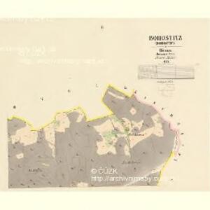
Bohostitz (Bohostice) - c0311-1-002 - Kaiserpflichtexemplar der Landkarten des stabilen Katasters
1 : 2880
Bohostitz (Bohostice) - c0311-1-003 - Kaiserpflichtexemplar der Landkarten des stabilen Katasters
1 : 2880
Bohostitz (Bohostice) - c0311-1-001 - Kaiserpflichtexemplar der Landkarten des stabilen Katasters
1 : 2880
Lesní zařizovací mapa revíru Zbenice 1

Zlakowitz - c9173-1-002 - Kaiserpflichtexemplar der Landkarten des stabilen Katasters
1 : 2880
Zlakowitz - c9173-1-001 - Kaiserpflichtexemplar der Landkarten des stabilen Katasters
1 : 2880
Kamena - c3011-1-001 - Kaiserpflichtexemplar der Landkarten des stabilen Katasters
1 : 2880
Kamena - c3011-1-002 - Kaiserpflichtexemplar der Landkarten des stabilen Katasters
1 : 2880
Přehledná mapa pozemkové držby velkostatku orlického v širším pojetí, podle stavu z roku 1916, list 2 1
1 : 25000
Přehledná mapa velkostatku Orlíka, Čimelic, Varvažova, Tochovic a přivtělených statků Bukovan, Zalužan a Zbenic podle majetkového stavu z r. 1913, list 2 1
1 : 25000
Smolotell - c7083-1-001 - Kaiserpflichtexemplar der Landkarten des stabilen Katasters
1 : 2880
Smolotell - c7083-1-004 - Kaiserpflichtexemplar der Landkarten des stabilen Katasters
1 : 2880
Smolotell - c7083-1-002 - Kaiserpflichtexemplar der Landkarten des stabilen Katasters
1 : 2880
Smolotell - c7083-1-003 - Kaiserpflichtexemplar der Landkarten des stabilen Katasters
1 : 2880
Smolotell - c7083-1-006 - Kaiserpflichtexemplar der Landkarten des stabilen Katasters
1 : 2880
Smolotell - c7083-1-005 - Kaiserpflichtexemplar der Landkarten des stabilen Katasters
1 : 2880
Zettin - c0752-1-002 - Kaiserpflichtexemplar der Landkarten des stabilen Katasters
1 : 2880
Zettin - c0752-1-001 - Kaiserpflichtexemplar der Landkarten des stabilen Katasters
1 : 2880
Zettin - c0752-1-003 - Kaiserpflichtexemplar der Landkarten des stabilen Katasters
1 : 2880
Přehledná mapa panství Orlíka a přivtělených statků Bukovan, Zalužan a Zbenic, list 3 1

Těchnice, Korce a Lub, okr. Příbram, list 2 list 2
1 : 2880
Technič - c7877-1-003 - Kaiserpflichtexemplar der Landkarten des stabilen Katasters
1 : 2880
Technič - c7877-1-006 - Kaiserpflichtexemplar der Landkarten des stabilen Katasters
1 : 2880
Technič - c7877-1-001 - Kaiserpflichtexemplar der Landkarten des stabilen Katasters
1 : 2880
Technič - c7877-1-005 - Kaiserpflichtexemplar der Landkarten des stabilen Katasters
1 : 2880
Technič - c7877-1-004 - Kaiserpflichtexemplar der Landkarten des stabilen Katasters
1 : 2880
Technič - c7877-1-002 - Kaiserpflichtexemplar der Landkarten des stabilen Katasters
1 : 2880
Zbenické Zlákovice, okr. Příbram, list 1 list 1
1 : 2880
Porostní mapa severní části velkostatku orlického pro vycházku České lesnické jednoty v měsíci srpnu 1893 1
1 : 25000