Maps of Pecka

Bilai (Běla) - c0187-1-001 - Kaiserpflichtexemplar der Landkarten des stabilen Katasters
1 : 2880
Bilai (Běla) - c0187-1-002 - Kaiserpflichtexemplar der Landkarten des stabilen Katasters
1 : 2880
Stabilní katastr - Procovní otisk Nieder Jaworz

Nieder Jaworz (Dolenj Jawoř) - c1302-1-001 - Kaiserpflichtexemplar der Landkarten des stabilen Katasters
1 : 2880
Nieder Jaworz (Dolenj Jawoř) - c1302-1-002 - Kaiserpflichtexemplar der Landkarten des stabilen Katasters
1 : 2880
Stabilní katastr - Procovní otisk Markt Petzka

Auhlirz - c8182-1-001 - Kaiserpflichtexemplar der Landkarten des stabilen Katasters
1 : 2880
Auhlirz - c8182-1-002 - Kaiserpflichtexemplar der Landkarten des stabilen Katasters
1 : 2880
Ratkin - c6359-1-002 - Kaiserpflichtexemplar der Landkarten des stabilen Katasters
1 : 2880
Ratkin - c6359-1-001 - Kaiserpflichtexemplar der Landkarten des stabilen Katasters
1 : 2880
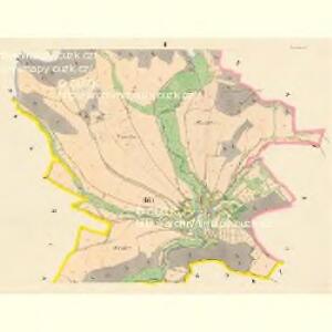
Petzka (Pecka) - c5677-1-004 - Kaiserpflichtexemplar der Landkarten des stabilen Katasters
1 : 2880
Petzka (Pecka) - c5677-1-003 - Kaiserpflichtexemplar der Landkarten des stabilen Katasters
1 : 2880
Petzka (Pecka) - c5677-1-001 - Kaiserpflichtexemplar der Landkarten des stabilen Katasters
1 : 2880
Petzka (Pecka) - c5677-1-002 - Kaiserpflichtexemplar der Landkarten des stabilen Katasters
1 : 2880
Stupnai (Stupna) - c7519-1-001 - Kaiserpflichtexemplar der Landkarten des stabilen Katasters
1 : 2880
Stupnai (Stupna) - c7519-1-003 - Kaiserpflichtexemplar der Landkarten des stabilen Katasters
1 : 2880
Stupnai (Stupna) - c7519-1-004 - Kaiserpflichtexemplar der Landkarten des stabilen Katasters
1 : 2880
Stupnai (Stupna) - c7519-1-002 - Kaiserpflichtexemplar der Landkarten des stabilen Katasters
1 : 2880
Bestandeskarte der Forste Bělohrad
1 : 10000 Lázně Bělohrad (Česko : oblast)
Bestandeskarte der Forste Bjelohrad
1 : 10000 Lázně Bělohrad (Česko : oblast)
Bestandeskarte der Forste Bjelohrad
1 : 10000 Lázně Bělohrad (Česko : oblast)
Bestandeskarte der Forste Bělohrad
1 : 10000 Lázně Bělohrad (Česko : oblast)
Bestandeskarte der Forste Bělohrad
1 : 10000 Lázně Bělohrad (Česko : oblast)
III. vojenské mapování 3855/1
1 : 25000

Jičín a okolí
1 : 75000 Jičín (Česko : oblast) Vojenský zeměpisný ústav
III. vojenské mapování 3855
1 : 75000
Jičín
1 : 75000 Dvůr Králové nad Labem (Česko : oblast) Vojenský zeměpisný ústav
Hořitz und Jičin
1 : 75000 Dvůr Králové nad Labem (Česko : oblast) Richter K. u. k. militär-geographisches Institut
Hořitz und Jičin
1 : 75000 Dvůr Králové nad Labem (Česko : oblast) Richter K. u. k. Militärgeographisches Institut