Maps of Vercelli

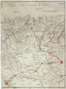
Viaggio della Francia in Italia
1 : 1230000 Milán (Itálie)
[Exactissima Helvetiae, Rhaetiae, Valesiae ... tabula]
1 : 850000 9 Karten [Kopie von Adrian Braakman] [chez Pierre Schenk et Adrian Braakman], [Amsterdam]

Biella
1 : 200000 1 Karte entworfen und bearbeitet von Woerl ; in Stein gestochen unter seiner Leitung 1835 ; Lithographie von B. Herder Herder, Freiburg im Breisgau
Descrittione di parte del Stato di Milano
Mollova mapová sbírka Cotta, Giacomo Cotta, Giacomo
Nova Rhaetiae atque totius Helvetiae descriptio
1 : 350000 1 Karte auf 10 Bl. per Aegidium Tschudum Glaronensem Hofer & Burger, Zürich
Parte Alpestre Dello Stato Di Milano, Con il Lago Maggiore Di Lugano, É Di Como [Karte], in: Le théâtre du monde, ou, Nouvel atlas contenant les chartes et descriptions de tous les païs de la terre, Bd. 3, S. 63.
1 Karte aus Atlas Blaeu, Willem Janszoon und Blaeu, Joan Blaeu, Willem Janszoon
Parte Alpestre Dello Stato Di Milano Con il Lago Maggiore Di Lugano, È Di Como [Karte], in: Novus atlas absolutissimus, Bd. 5, S. 71.
1 Karte aus Atlas Janssonius Offizin
Parte Alpestre Dello Stato Di Milano, Con il Lago Maggiore Di Lugano, È Di Como [Karte], in: Novus Atlas, das ist, Weltbeschreibung, Bd. 3, S. 73.
1 Karte aus Atlas Blaeu, Joan Blaeu, Willem Janszoon
[Keller's Reisekarte der Schweiz]
1 : 500000 1 Karte auf 6 Bl. gezeichnet v. H. Keller ; gest. v. J.J. Scheurmann [Keller], Zürich
Parte Alpestre Dello Stato Di Milano, Con il Lago Maggiore Di Lugano, É Di Como [Karte], in: Theatrum orbis terrarum, sive, Atlas novus, Bd. 3, S. 61.
1 Karte aus Atlas Blaeu, Joan Blaeu, Willem Janszoon
Le Grand Teatre de la Guerre en Italie
1 : 430000 Mollova mapová sbírka Mortier, Pieter Mortier, Pierre
Ducatus Mediolanensis Placentini et Permensis nova Tabula
1 : 750000 Mollova mapová sbírka Kauffer, Michael
Belli Typvs in Italia
1 : 520000 Mollova mapová sbírka Homann, Johann Baptist Homann, Johann Baptista
Belli Typvs in Italia
1 : 520000 Mollova mapová sbírka Homann, Johann Baptist Homann, Johann Baptista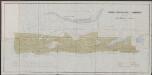
Signoria di Vercelli [Karte], in: Le théâtre du monde, ou, Nouvel atlas contenant les chartes et descriptions de tous les païs de la terre, Bd. 3, S. 42.
1 Karte aus Atlas Blaeu, Willem Janszoon und Blaeu, Joan Blaeu, Willem Janszoon
Signoria di Vercelli [Karte], in: Theatrum orbis terrarum, sive, Atlas novus, Bd. 3, S. 43.
1 Karte aus Atlas Blaeu, Joan Blaeu, Willem Janszoon
Signoria Di Vercelli [Karte], in: Novus atlas absolutissimus, Bd. 5, S. 93.
1 Karte aus Atlas Janssonius Offizin
Signoria Di Vercelli [Karte], in: Gerardi Mercatoris et I. Hondii Newer Atlas, oder, Grosses Weltbuch, Bd. 2, S. 273.
1 Karte aus Atlas Mercator, Gerhard und Hondius, Jodocus Jansson, Jan
Signoria di Vercelli [Karte], in: Novus Atlas, das ist, Weltbeschreibung, Bd. 3, S. 51.
1 Karte aus Atlas Blaeu, Joan Blaeu, Willem Janszoon
SIGNORIA | di | VERCELLI.
[Amsterdam : Joan Blaeu]
Viaggio ai tre laghi
1 : 188000 Stucchi
PARTE ALPESTRE | DELLO STATO DI | MILANO, | Con il LAGO MAGGIORE | DI LUGANO, É DI COMO
[Amsterdam : Joan Blaeu]

Nova Rhaetiae atque totius Helvetiae descriptio
1 : 350000 1 Karte auf 10 Bl. per Aegidium Tschudum Glaronensem Hofer & Burger, Zürich
Majeure partie des Cantons de Bellinzona et de Lugano et les frontieres de la Republique Italienne.
From Atlas Suisse. Levé et dessiné par J. H. Weiss aux fraix de J. R. Meyer á Aarau dans les années 1786 á 1802. Gravée par Guerin, Eichler, et Scheurmann.
Atlas Suisse
1 : 120000 16 Karten levé et dessiné par J.H. Weiss [et Joachim Eugen Müller] aux frais de J.R. Meyer à Aarau dans les années 1786 à 1802 ; gravée [sic] par [Christophe] Guérin, [Matthias Gottfried] Eichler et [Johann Jakob] Scheurmann [Johann Rudolf Meyer], Aarau
Parte Alpestre dello Stato di Milano
1 : 340000 Mollova mapová sbírka Valk, Gerhard Schenk, Peter I