Maps of okres Přerov

[Die Markgraftschaft Mähren]
1 : 200000 Přerov-oblast (Česko) Schenkl, Conrad Philipp Carl Winiker
Die Markgraftschaft Mähren
1 : 22000 Přerov-oblast (Česko) Schenkl, Conrad Philipp Carl Winiker
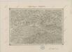
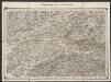
Circuli Preroviensis Pars Australis
1 : 233300 Mollova mapová sbírka Müller, Johann Christoph Homann, Johann Baptista
Marchionatus Moraviae Circulus Preroviensis

Der Prerauer Kreis
1 : 200000 Přerov-oblast (Česko) Schenkl, Conrad Philipp Winiker, Karel Carl Winiker
Der Prerauer Kreis
1 : 200000 Přerov-oblast (Česko) Schenkl, Conrad Philipp Winiker, Karel Carl Winiker
Der Prerauer Kreis
1 : 200000 Přerov-oblast (Česko) Schenkl, Conrad Philipp Winiker, Karel Carl Winiker
Marchionatus Moraviae Circulus Preroviensis pars Australis

Marchionatus Moraviae Circulus Preroviensis

[Marchionatus Moraviae circulus Preroviensis]
Morava (Česko) Müller, Johann Christoph Homann, Johann Baptist Io. Baptista Homanno
[Marchionatus Moraviae circulus Preroviensis]
Morava (Česko) Müller, Johann Christoph Homann, Johann Baptist Io. Baptista Homanno
Circuli Preroviensis pars australis
1 : 150000 Morava (Česko) Müller, Johann Christoph
Marchionatus Moraviae circulus Preroviensis
1 : 150000 Morava (Česko) Müller, Johann Christoph Homann, Johann Baptist Io. Baptista Homanno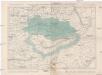
Politické okresy valašskomeziříčský a vsetínský
1 : 200000 Valašské Meziříčí-oblast (Česko) Plesinger, Václav V. Plesinger
Moravskoslezské Bezkydy
1 : 100000 Javorníky (Česko a Slovensko) Karl, F. Pták, J. nákladem Pobezkydské župy
Beskydy

Beskydy

Turistické cesty na Valašsku
Beskydy

Hranice a okolí
II. vojenské mapování 10
1 : 144000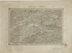
II. vojenské mapování 10
1 : 144000
Neutitschenein.
from Spezialkarte der osterreichisch-ungarischen Monarchie.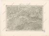
Special - Karte der Markgrafschaft Maehren und des Herzogthums Schlesien
Umgebungen von Weiskirchen
1 : 144000 K.K. Militärisches Geographisches Institut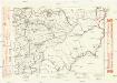
Komunikační mapa země Moravskoslezské
1 : 100000 Vsetín (Česko : oblast) Morslez. zem. výbor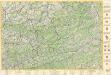
Beskydy

156. Hultschin, uit: Topographische Uebersichtskarte des Deutschen Reiches / herausgegeben v. d. Kartogr. Abt. d. Königl. Preuß. Landesaufnahme
1 : 200000 titelvariant: Topogr. Übersichtskarte des Deutschen Reiches; Annotatie: Titel boven bladen ook: Topogr. Übersichtskarte des Deutschen Reiches; Annotatie geografische gegevens: Op elk blad twee maatstokken: 10 Kilometer = 5,5 cm; 1 geogr. Meile = 3,6 cm; Legenda onder op elk blad Königlich Preußische Landesaufnahme. Kartographische Abtheilung [S.l : Königlich Preußische Landesaufnahme, Kartographische Abtheilung]
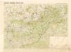
Okresní hejtmanství Novojičínské

![[Die Markgraftschaft Mähren]](https://images-2.georeferencer.com/images/iiif/178547202041/full/,300/0/native.jpg)

