Maps of Netherlands

Carte des environs de l'Escaut
1 : 420000 Flandry Hahn, Gustav Leopold Gürsch, Carl Friedrich F. Nicolai
Les XVII provinces du Pais-Bas
1 : 264000 Belgie Aa, Pieter van der George P. van der Aa
Holland, Friesland, Groningen, Overyssel, Gelders, Utrecht and Zealand.
1 : 2471040 Carey, Mathew
The Seven United Provinces of Holland, Groningen, Gelders, Friesland, Overyssel, Utrecht and Zealand.
1 : 2407680 Carey, Mathew
The Seven United Provinces of Holland, Groningen, Gelders, Friesland, Overyssel, Utrecht and Zealand.
1 : 2407680 Carey, Mathew
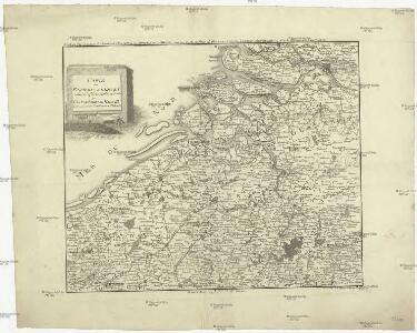
Pays Bas septentrionale.
1 : 1130000 Janvier, Jean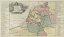
Descriptio veteris Agri Batavi et Frisi omnisque regionis quae hodie est in dicione VII. Foederatorvm cis et ultra Rhenvm
1 : 1100000 Mollova mapová sbírka Alting, Menso
The Seven United Provinces of Holland, Groningen, Gelders, Friesland, Overyssel, Utrecht, and Zealand.
1 : 1180000 Melish, John
Carte des Provinces Unies des Pays Bas
1 : 700000 Mollova mapová sbírka Delisle, Guillaume Covens, Johannes I
Carte Des Provinces Unies Des Pays-Bas
1 : 690000 Mollova mapová sbírka Delisle, Guillaume L'Isle, Guillaume de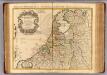
Provinces Unies des Pays Bas.
1 : 690000 L'Isle, Guillaume de, 1675-1726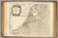
Provinces Unies des Pays Bas.
1 : 690000 L'Isle, Guillaume de, 1675-1726
[129][132] Pascaert van de Noord Zee ... Mare Germanicum ..., uit: Atlas sive Descriptio terrarum orbis
Annotatie: Gedigitaliseerde versie. Amsterdam. Heiloo : Picturae (vervaardiger), 2015. tiff-bestand. Gedigitaliseerd: 07-01-2015; Origineel: Universiteitsbibliotheek Vrije Universiteit (XL.05127.-) ; Netherlands; Titelpagina ontbreekt Wit, Frederik de Amsterdam : Frederick de Wit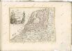

Republik der Vereinigten Niederlande Innerer Aufbau 1648
Niederlande Verwaltungsgliederung Kunz, Andreas ; Moeschl, Joachim Robert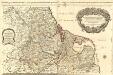
Les Dix-Sept Provinces des Pays-Bas
1 : 1050000 Mollova mapová sbírka Sanson, Guillaume Jaillot, Alexis Hubert
Belgii pars septentrionalis communi nomine vulgo Hollandia ... = Land caerte van ’t Verenigde Nederland met ’t gene daer onderhoort, verdeelt in syn provincien en minder verdelingen
1 : 800000 naaukeurig aangewesen en uyt de beste aantekeninge opgestelt. Ultrajecti : Cornelius Kribber
A new and correct map of the seven provinces : drawn from the most approved maps and charts : the whole being regulated by astronomical observations
1 : 920000 by Eman Bowen. [London] : Tyndal
Belgii pars septentrionalis communi nomine vulgo Hollandia ...
1 : 640000 edente Petro Schenkio Amstelaedami : Petrus Schenkius
Belgii Foederati Nova Descriptio. [Karte], in: Novus atlas absolutissimus, Bd. 3, S. 28.
1 Karte aus Atlas Janssonius Offizin
Souhvězdí naší oblohy
Nizozemsko Studnička, Alois Stumper, Č. Alois Studnička
Köenigreich Niederland nach der letzten Grenz-Berichtigung verfasst
1 : 1200000 Nizozemsko Mollo, Tranquillo Tranquillo Mollo
Köenigreich Niederland nach der letzten Grenz-Berichtigung verfasst
1 : 1200000 Nizozemsko Tranquillo Mollo
Les Dix-Sept Provinces Des Pays-Bas
1 : 760000 Mollova mapová sbírka Sanson, Guillaume Sanson, Guillaume
Provinces Vnies de Pays Bas
1 : 861000 Nizozemsko
[Kaart], uit: Grande carte routière de la Hollande (Pays-Bas, Nederland) à l'usage des automobiles, cyclistes, touristes, etc. / P. Bineteau, del.
1 : 400000 Bineteau, P. Paris : Taride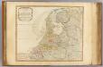
Seat of war United Provinces.
1 : 575000 Robert Laurie & James Whittle
Het Graafschap Hollandt.
1 : 4500000 Te Amsterdam : bij B. Mourik
BELGICA | FOEDERATA
[Amsterdam : Joan Blaeu]