Maps of Dresden
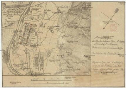
Situations Plan des exerc. Lagers des churf. saechs. Armee bey Dresden im Septbr. 1802
1 : 120000 Drážďany-oblast (Německo)
Plan‘‘sraženija pri Drezdeně 15. Avgusta 1813 goda
Deutschland Dresden Befreiungskriege <1813-1815>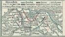
Dresden 26. u. 27. August 1813
1 : 300000 Dresden Dresden / Schlacht <1813>
Meßtischblatt 66 : Dresden, 1930
1 : 250000 Dresden. - Aufgen. 1908/09, hrsg. 1910, bericht. 1928, einz. Nachtr. 1930. - 1:25000. - Leipzig, 1930. - 1 Kt.
Meßtischblatt 66 : Dresden, 1925
1 : 250000 Dresden. - Umdr.-Ausg., aufgen. 1908/09, hrsg. 1910, Nachtr. 1925. - 1:25000. - Leipzig, 1925. - 1 Kt.
Plan von Dresden

Pharus-Plan Dresden
1 : 11700 Pharus-Verlag Pharus-Verlag
Plan von Dresden : im Maaβsstab 1:15000 der nat. Grösse
1 : 15000 Kiesling, A Verlag von H. Jaenicke
Pharus-Plan Dresden
1 : 11700 Berlin : Pharus-Verlag [etc.]
Plan von Dresden : 1902
1 : 10000 Vermessungsamt der Stadt Dresden Giesecke & Devrient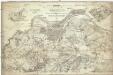
Plan von der Schlacht bei Dresden, geliefert von der grossen böhmischen und der französischen Armée am 27, Aug. 1813
1 : 23000 Drážďany (Německo) Renner, F. A. Arnold'sche Buch- und Kunsthandlug
Plan von Dresden

Dresden
1 : 25000 Drážďany (Německo)
Plan von Dresden mit den einverleibten Vororten
Reichel, Otto
Plan von Dresden
Loofs, Emil Conrad Weiske
Plan von Dresden
1 : 15000 Drážďany (Německo) C.C. Meinhold u. Söhne
Dresden und seine Umgebungen
1 : 16000 Drážďany-oblast (Německo) Lehmann, Johann Georg Keyl, C. in der Arnoldischen Buch und Kunsthandlung
Dresden und seine Umgebungen
Lehmann, Johann Georg; Keyl, Christian Karl Maximilian Arnold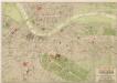
Pharus - Plan Dresden

Pharus-Plan Dresden
1 : 11700 Drážďany (Německo) Pharus-Verlag
Plan von Dresden
1 : 12500 Drážďany (Německo) Herrmann, Paul Vereins zur förderung Dresden und des Fremdenverkehrs
Plan von der Stadt Dresden und ihren Ungebungen

Plan von Dresden

Plan von Dresden
Goldschmidt, Albert.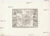
Dresden
1 : 20700 Drážďany (Německo : oblast) Meyer, Joseph der geographischen Anstalt des Bibliographischen Instituts
Plan von der Stadt Dresden und ihren Umgebungen
1 : 18500 Drážďany (Německo) Kühleman Bach, Joseph Rittner
Dresda ad Albim, Saxoniæ superioris metropolis ac magnifica ducis electoris et regis Poloniæ sedes = Dresden an der Elb, eine Haupt-Stadt des Obern Sachsen, ũ: höchst vortreffliche Residentz des dasigon Churfürsten ũ: Konigs in Pohlen
Seutter, Matthaeus, 1678-1756 Matth. Seutter
Plan von der churfürstl. saechsischen Residenz Dresden
Drážďany (Německo) Albrecht, Andreas Börner, G.
[Plan von der churfürstl. saechsischen Residenz Dresden]
1 : 18228 Drážďany (Německo)