Maps of Leningrad

Ladožskoj kanal
1 : 142000 Rusko Seutter, Matthäus Matthaeus Seutter
Ladožskīe kanaly
Russland Russland (Nord) Ladoga-Kanal Schifffahrtskanal Il'in', N.
Tečenjije Něpy rěki iz Ladolskago ozera k St. Peterburgu
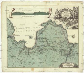
Ladožské jezero (Rusko) Seutter, Matthäus Matthaeus Seutter
Ladožskoje ozero i Finskij zalip s prilěžaščimi městami
Finský záliv Seutter, Matthäus Matthaeus Seutter
Ingermanlandiae seu Ingriae novissima tabula / luci tradita per Homannianos Heredes
1 : 390000 1 Karte : Kupferdruck ; 46 x 55 cm Rostovčev, Aleksej Ivanovič Homännische Erben
Ingermanlandiae seu Ingriae novissima tabula
1 : 390000 Petrohrad (Rusko) per Homannianos heredes
INGRIA.
[Amsterdam : Joan Blaeu]
St. Petersburg, Tichwin
1 : 750000 Petrohrad (Rusko) K. u. k. Militärgeographisches Institut
Nova et accurata delineatio Ingriae et Careliae cum magna parte sinus Finnici et lacus Ladogae, nec
1 : 610000 1 Karte : Kupferdruck ; 55 x 47 cm Seutter, Matthäus [Matthäus Seutter]
Ethnographische Karte des St. Petersburgischen Gouvernements
Gouvernement Sankt Petersburg Ethnische Gruppe, Bevölkerung Keppen, Petr I.
Nova et accurata delineatio Ingriae et Careliae cum magna parte Sinus Finnici et Lacus Ladogae, nec non insularum adjacentium
1 : 1210000 Finsko Seutter, Matthäus Matthaeus Seutter
Etnographische Karte des St. Petersburgischen Gouvernements
1 : 1300000 Petrohrad-oblast (Rusko) Koeppen, P. von K. Akademie der Wissenschaften zu St. Peterburg
Province de St. Petersbourg
1 : 840000 [St. Petersbourg] : [A. Iljin]
General'naja Karta Sanktpeterburgskoj Gubernii
1 : 1125000 composé et gravée par Piadicheff les leteres grav. M. Iwanoff St. Petersbourg, [s.n.]
Nieuwe kaart van de Finnissche Golf benevens de omliggende provintien : naar de beste kaarten en sterrekundige waarnemingen geteekend in 't Konigl. Landmeeters Comtoir te Stockholm
1 : 1200000 C. van Baarsel sculp. te Amsterdam : bij J. Covens en Zoon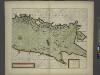
The coast of LYF LAND and East FINLAND from Wolf to Wybourgh and soto Elsenvos
from The sea-atlas : containing an hydrographical description of most of the sea-coasts of the known parts of the world.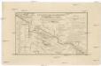
Karta napravlenija železnoj dorogi šossei i vodjanych soobščenij meždu S. Peterburgom i Moskvoju
1 : 1300000 Moskva-oblast (Rusko) Al'tman, I. Flerov, V. v Zavedenii kongrevskoj chromotipii F. Tuma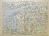
Von Riga nach St. Petersburg
1 : 2600000 Baltikum
Russia Part lII.
1 : 1770000 Society for the Diffusion of Useful Knowledge (Great Britain)
Sinus Finnici delineatio geographica / ex quam plurimis subsidiis novissimis stereographice tradita
1 : 1000000 1 Karte auf 2 Blatt : Kupferdruck ; 44 x 81 cm Mayer, Tobias [Homännische Erben]
Russia Part lV.
1 : 1770000 Society for the Diffusion of Useful Knowledge (Great Britain)
Russia 3.
1 : 1900800 Letts, Son & Co.
Russia 4.
1 : 1900800 Letts, Son & Co.
Eisenbahnkarte von Finnland
Finnland Eisenbahnnetz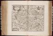
Rvssiæ, vulgo Moscovia dictæ, pars occidentalis / auctore Isaaco Maßa
1 : 2000000 Annotatie: Kaart is vervaardigd omstreeks 1638, en gepubliceerd in de Atlas Maior in 1662; Met wapen; Origineel is Blad 138 in atlas factice; Annotatie geografische gegevens: Met 2 schaalstokken Isaac Abrahamszoon Massa 1586-1643 [Amsterdam : apud Johan. et Cornelium Blaeu]
Partie, Russie d'Europe. Europe 10.
1 : 1641836 Vandermaelen, Philippe, 1795-1869
Karte von Finnland
1 : 2400000 Evropa Finland Steamship
RVSSIÆ, | Vulgo MOSCOVIA dictæ, | Pars Occidentalis
Auctore Isaaco Maßa. [Amsterdam : Joan Blaeu]
Russland
1 : 3360000 Estonsko Renner Kleinknecht