Maps of Regional Unit of Boeotia
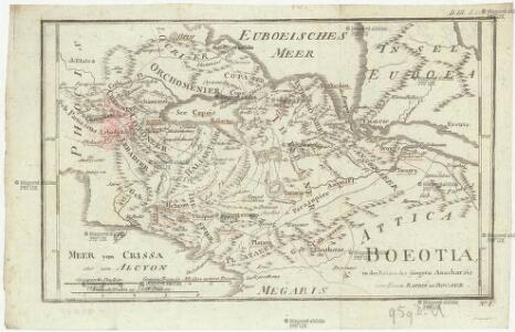
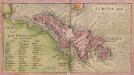
Boeotia
1 : 435000 Barbié du Bocage, Jean Denis
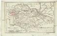
Boeotien
1 : 291000 Řecko Müller, Karl Otfried Gleditsch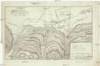
Versuch über das Treffen bey Plataea
1 : 39000 Barbié du Bocage, Jean Denis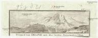
Prospect von Delphi und den beyden Parnassischen Felsen
Delfy (Řecko)
Attica Megarica Corinthiaca Boeotia Phocis Locri
Atika, poloostrov (Řecko) Velius, Theodorus Hondius, Henricus sumptibus Henrici Hondii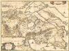
Attica, Mecarica, Corinthiaca, Boeotia, Phocis, Locri. [Karte], in: Novus atlas absolutissimus, Bd. 10, S. 131.
1 Karte aus Atlas Janssonius Offizin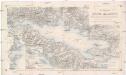
Der Meerbusen von Korinth oder Lepanto
1 : 200000 Korintský záliv (Řecko : oblast) Stanley, Owen Mannsell, A. L. Depot de la guerre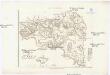
Karte von Attika
1 : 33000 Atika, poloostrov (Řecko) Müller, Karl Otfried Gleditsch
Italien und Balkanhalbinsel. Nebenkarten II. 1. Athen und der Isthmus von Korinth
Attika
Phocis und Doris
1 : 435000 Barbié du Bocage, Jean Denis
Chartes Attikes
1 : 100000 Atika, poloostrov (Řecko) Eleutheroudakes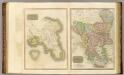
Attica, Turkey in Europe.
Thomson, John
Versuch über die umliegenden Gegenden von Delphi
1 : 100000 Delfy (Řecko) Barbié du Bocage, Jean Denis
[Griechenland]
1 : 2500000 Griechenland
Archipelagi Insularum Aliquot Descrip., [Negroponte] [Karte], in: Theatrum orbis terrarum, S. 246.
1 Karte aus Atlas Ortelius, Abraham
Insular. Aliquot Aegaei Maris Antiqua Descrip.[:] [Euboea, Insula.] [Karte], in: Theatrum orbis terrarum, S. 419.
1 Karte aus Atlas Ortelius, Abraham
Morea olim Peloponnesus [Karte], in: Novus atlas absolutissimus, Bd. 5, S. 289.
1 Karte aus Atlas Janssonius Offizin
Morea olim Peloponnesus [Karte], in: Gerardi Mercatoris et I. Hondii Newer Atlas, oder, Grosses Weltbuch, Bd. 2, S. 333.
1 Karte aus Atlas Mercator, Gerhard und Hondius, Jodocus Jansson, Jan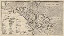
Insular. Aliquot Aegaei Maris Antiqua Descrip.[:] Euboea, Insula.[Karte], in: Theatrum orbis terrarum, S. 517.
1 Karte aus Atlas Ortelius, Abraham Vrients, Jan Baptista
Morea olim Peloponnesus [Karte], in: Gerardi Mercatoris Atlas, sive, Cosmographicae meditationes de fabrica mundi et fabricati figura, S. 490.
1 Karte aus Atlas Mercator, Gerhard Montanus, Petrus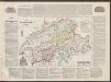
Morea olim Peloponnesus. [Karte], in: Le théâtre du monde, ou, Nouvel atlas contenant les chartes et descriptions de tous les païs de la terre, Bd. 3, S. 304.
1 Karte aus Atlas Blaeu, Willem Janszoon und Blaeu, Joan Blaeu, Willem Janszoon
Archipelagi Insularum Aliquot Descrip., [Negroponte] [Karte], in: Theatrum orbis terrarum, S. 341.
1 Karte aus Atlas Ortelius, Abraham Vrients, Jan Baptista

Griechenland
1 : 2000000 Griechenland
Negroponte In. [Karte], in: Gerardi Mercatoris Atlas, sive, Cosmographicae meditationes de fabrica mundi et fabricati figura, S. 523.
1 Karte aus Atlas Mercator, Gerhard Montanus, Petrus
Graeciae pars australis.
1 : 2100000 Fenner, Rest.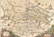
Achaiae Nova & accurata Descriptio. [Karte], in: Novus atlas absolutissimus, Bd. 10, S. 102.
1 Karte aus Atlas Janssonius Offizin
Morea ilim Peloponnesus. [Karte], in: Theatrum orbis terrarum, sive, Atlas novus, Bd. 3, S. 294.
1 Karte aus Atlas Blaeu, Joan Blaeu, Willem Janszoon