Maps of Czech Republic

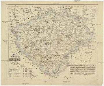
Mapa království Českého
1 : 800000 Čechy (Česko) Krečmar, Bedřich tisk a sklad Bedř. Krečmara
Entwurf einer Uibersicht der neuen Entheilung der Kronlandes Böhmen
Čechy (Česko) Stifter, Johann Steyrer, Fr. C. Fr.C. Steyrer
Čechy, mapa isogon pro epochu 1925.5, Zěmě Moravsko - Slezská, mapa Isogon

Mapa škol Království českého
Hradec Králové (Česko) Mařatka, František nákladem literárního odboru Ústředního spolku
Mapa škol Království českého
Hradec Králové (Česko) Mařatka, František Otto, Jan J. Otto
Mittelbach's neueste Specialkarte von Böhmen zum Hand- und Kontorgebrauch
1 : 300000 Česko Mittelbach Mittelbach's Verlag
Generální mappa [sic] Království českého
1 : 432000 Česko Kořistka, Karel František Edvard sklad Eduarda Hölzela
Geonomická mapa Čech
Archäologische Karte des Königreiches Böhmen
Čechy (Česko) Schmitt, Anton Wagner, Jan Eduard Anton Schmitt
Archäologische Karte des Königreiches Böhmen
Čechy (Česko) Schmitt, Anton Wagner, Jan Eduard Anton Schmitt
Archäologische Karte des Königreiches Böhmen
Čechy (Česko) Schmitt, Anton Wagner, Jan Eduard Anton Schmitt
Historisch-geographisch-statistisch-gefaellsaemtliche KARTE vom Königreiche Böhmen
1 : 1040000 Česko Bastien, Joseph Mayregg, Cajetan von Cajetan von Mayregg
Historisch-geographisch-statistisch-gefaellsaemtliche Karte vom Königreiche Böhmen
1 : 1040000 Česko Bastien, Joseph Mayregg, Cajetan von Cajetan von Mayregg
Historisch-geographisch-statistisch-gefaellsaemtliche Karte vom Königreich Böhmen
1 : 1040000 Čechy (Česko) Bastien, Joseph Mayregg, Cajetan von Cajetan von Mayregg
Přehledná mapa pokračovacích škol průmyslových, kupeckých a j. v Království českém
Česko c. a k. dvorní litografie A. Haase
Karte des Königreiches Böhmen
Bez titulu: Soubor statistických map Čech

Statistické mapy Království českého
Čechy (Česko) Kořistka, Karel František Edvard vydané Centralním komitétem pro hosp. a lesnick. statistiku Čech
Statistické mapy Království českého
Čechy (Česko) Kořistka, Karel František Edvard vydané Centralním komitétem pro hosp. a lesnick. statistiku Čech
Statistické mapy Království českého
Čechy (Česko) Kořistka, Karel František Edvard vydané Centralním komitétem pro hosp. a lesnick. statistiku Čech
Statistické mapy Království českého
Čechy (Česko) Kořistka, Karel František Edvard vydané Centralním komitétem pro hosp. a lesnick. statistiku Čech
Statistické mapy Království českého
Čechy (Česko) Kořistka, Karel František Edvard vydané Centralním komitétem pro hosp. a lesnick. statistiku Čech
Statistické mapy Království českého
Čechy (Česko) Kořistka, Karel František Edvard vydané Centralním komitétem pro hosp. a lesnick. statistiku Čech
Statistické mapy Království českého
Čechy (Česko) Kořistka, Karel František Edvard vydané Centralním komitétem pro hosp. a lesnick. statistiku Čech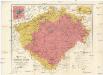
Uibersichtskarte des Königreiches Böhmen
1 : 576000 Jablonec nad Nisou (Česko : oblast) Wagner, Jan Eduard F. Kytka
Karten zur Statistik des Königreiches Böhmen...

Generální mapa Království českého
1 : 220000 Čechy (Česko) Wagner, Jan Eduard Mareš, František F. Kytka
Karte des landtäflichen Grossgrund-Besitzes im Königreiche Böhmen nach der ehem. Domanial-Umgrenzung mit Angabe der positiven Grösse des Besitzes
1 : 600000 Čechy (Česko) Hickmann, Anton L. A.L. Hickmann
Karte der Kreisgerichts-Sprengel und Gerichts-Bezirke des Königreiches Böhmen nebst den fertigen und projectirten Eisenbahn-Linien
1 : 600000 Čechy (Česko) Hickmann, Anton L. A.L. Hickmann