Maps of Belfort

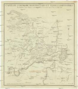
Carte du comté de Montbeliard et terres limitrophes
1 : 65000 Montbéliard (Francie) Weis
Carte du district de Montbeliard et terres limitrophes
1 Karte : Kupferdruck ; 52 x 45 cm Weis s.n.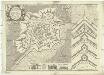
Besfort
1 : 2800 Belfort (Francie) Du Chaffat, Antoine par du Chaffat
[Vesoul]
1 Blatt : 61 x 92 cm Durand s.n.
Sequani Partie des Archidconnes de Favernay et de Luxeuil du Dioecese de Besancon
1 : 240000 Mollova mapová sbírka Sanson, Nicolas Somer, Jean Pruthenus Sanson, Nicolas
Basel 154, uit: Special-Karte von Mittel-Europa / nach amtlichen Quellen bearbeitet von W. Liebenow
1 : 300000 titelvariant: W. Liebenow's Mittel-Europa; Annotatie: Titel boven de bladen: W. Liebenow's Mittel-Europa Johannes Wilhelm Liebenow 1822-1897 Frankfurt a. M. : Ludwig Ravenstein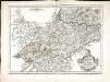
Rauraci
1 Karte : Kupferdruck ; 37 x 52 cm Sanson; Robert de Vaugondy; Somer chés le Sr. Robert g. du roi quai de l'Horloge du Palais
Département du Haut Rhin
1 Karte : Kupferdruck ; 35 x 39 cm Capitaine s.n.
Sequani
1 Karte : Kupferdruck ; 39 x 47 cm Sanson; Robert de Vaugondy; Somer chez le Sr. Robert geographe ordin. du roy quai de l'Horloge du Palais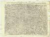
Carte topographique d'Allemagne
1 : 224000 Alsasko (Francie) Jaeger, Johann Wilhelm Abraham I.W.A. Iaeger
Carte topographique d'Allemagne
1 : 224000 Alsasko (Francie) Jaeger, Johann Wilhelm Abraham I. W. A. Iaeger
Le Theatre de Bellone :
Mollova mapová sbírka Schenk, Pieter Braakman, Adriaan
Territory Basiliensis Nova Descriptio
1 : 21000 Mollova mapová sbírka Janssonius, Johannes Janssonius, Johannes I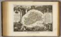
Dept. De La Hte. Saone.
1 : 571000 Levasseur, Victor.
Le cours du Rhin de Bâle à Hert près Philisbourg contenant l'Alsace et partie du Brisgau, 1
1 Blatt : 76 x 52 cm Le Rouge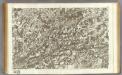
145 Vesoul.
1 : 86400 Cassini family; Cassini, Cesar-Francois, 1714-1784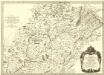
Sequani Partie des Archidconnes. de Favernay et de Luxeuil du Dioecese de Besançon
1 : 240000 Mollova mapová sbírka Sanson, Nicolas Somer, Jean Pruthenus Mariette, Pierre
184. Gebweiler, uit: Topographische Uebersichtskarte des Deutschen Reiches / herausgegeben v. d. Kartogr. Abt. d. Königl. Preuß. Landesaufnahme
1 : 200000 titelvariant: Topogr. Übersichtskarte des Deutschen Reiches; Annotatie: Titel boven bladen ook: Topogr. Übersichtskarte des Deutschen Reiches; Annotatie geografische gegevens: Op elk blad twee maatstokken: 10 Kilometer = 5,5 cm; 1 geogr. Meile = 3,6 cm; Legenda onder op elk blad Königlich Preußische Landesaufnahme. Kartographische Abtheilung [S.l : Königlich Preußische Landesaufnahme, Kartographische Abtheilung]
Belfort, Basel
1 : 100000 1 Karte par Aug. Jaccard et Alb. Muller [i.e. Müller] [Wurster & Randegger], [Winterthur]
Le Theatre de la Guerre Sur le Haut Rhein
1 : 142000 Mollova mapová sbírka Sanson, Guillaume
Topographische Karte der Schweiz
1 : 100000 25 Karten vermessen und hrsg. auf Befehl der Eidgenössischen Behörden ; aufgenommen unter der Aufsicht des Generals G.H. Dufour Eidg. Topographisches Bureau, [Genève], [später: Bern]
Blatt II: Belfort, Basel, uit: Topographische Karte der Schweiz / vermessen und hrsg. ... unter Aufsicht des Generals G.H. Dufour
1 : 100000 Annotatie: Met plaatsnamenregister (bl. V), bladwijzer (bl. XXI) en hoogteregister (bl. XXV); Voor aanwezige bladen zie overzichtsblad Dufour, G. H. [Bern : Eidg. Topogr. Bureau]
Carte topographique des limites d'une partie de la principauté le l'Lveche de Bâle centre les terre de France, conformément au Traitté d'Echange, arretté entre Sa Majesté tres chretienne et Son Altesse le prince-eveque de Bâle le 20. juin, ratifié le 11 juillet 1780
1 : 75000 Alsasko (Francie)
Belfort

Le Flambeau de la Guerre Allumee au Rhin
Mollova mapová sbírka Delisle, Guillaume Schenk, Peter II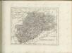

Département du Haut Rhin
1 Karte : Kupferdruck ; 48 x 48 cm Houdan au bureau de l'atlas national rue de la Harpe no. 26, et au depôt de cet atlas rue de la Monnoye no. 5
Basiliensis Territorii Descriptio Nova
1 : 310000 Mollova mapová sbírka Münster, Sebastian Plantin, Christoph
Basel 154, uit: [W. Liebenow's Special-Karte von Mittel-Europa]
1 : 300000 titelvariant: W. Liebenow's Mittel-Europa; Annotatie: Titel boven de bladen: W. Liebenow's Mittel-Europa Johannes Wilhelm Liebenow 1822-1897 Hannover : Hermann Oppermann