Maps of Hesse

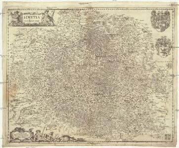
Hassia landgraviatus
1 : 440000 Hesensko (Německo)
Mappa Circuli Rhenani Superioris
1 : 460000 Mollova mapová sbírka Seutter, Matthäus Seutter, Matthäus
S. R. I. Circulus Rhenanus Superior
1 : 470000 Mollova mapová sbírka Homann, Johann Baptist Homann, Johann Baptista - dědici
S. R. I. Pars Septentrionalior Superioris Circuli Rhenani
1 : 460000 Mollova mapová sbírka Wit, Frederik de Covens, Johannes I
Parte Inferiore Del Circolo Dell' Alto Reno
Mollova mapová sbírka Cantelli, Giacomo Messis, Francesco Donia De Rossi, Giovanni Giacomo
Pars altera seu Borealis Circuli Rhenani, Vulgo qui Superior: In quo primas facit Hassiae Lant Graviatus
1 : 540000 Mollova mapová sbírka Valk, Gerhard
Neueste Karte vom Kurfürstenthum Hessen
Grosser Hand-Atlas über alle Theile der Erde in 170 Karten Meyer, J. Verlag des Bibliographischen Instituts
Superior et Inferior Hassiae Landgraviatus in suos Ducatus, Comitatus Abbatias Praefectur. accuratissime distinctus cura et impensis
1 : 540000 Mollova mapová sbírka Seutter, Matthäus Lotter, Tobias Conrad Seutter, Matthäus
Superior et inferior Hassiæ landgraviatus
1 Karte : Kupferdruck ; 47 x 54 cm Seutter; Lotter Matthäus Seutter
Parte Inferiore Del Circolo Dell' Alto Reno
Franconia, XII. Nova Tabula. [Karte] , in: Claud. Ptolemaeus. Geographia lat. cum mappis [...], S. 386.
1 Karte aus Atlas Münster, Sebastian [und Ptolemaeus, Claudius]
Franconia, XII. Nova Tabula. [Karte] , in: Geographia universalis vetus et nova complectens Claudii Ptolemaei Alexandrini enarrationis libros VIII, S. 332.
1 Karte aus Atlas Münster, Sebastian [und Ptolemaeus, Claudius]
Nr. 16 Franken [kaart], uit: Shell Strassenkarte
1 : 470000 Annotatie: Voor aanwezige bladen zie overzichtsblad; Incompleet [S.l. : Shell Reisedienst]
Königreich Bayern
Grosser Hand-Atlas über alle Theile der Erde in 170 Karten Meyer, J. Verlag des Bibliographischen Instituts
Charte von Kur-Hessen / gezeichnet und hrsg. von C. Fembo ; berichtigt von I.L. Kellermann
1 : 300000 Annotatie: Met administratieve indeling Fembo, C.; Kellermann, I. L. Nürnberg : [Fembo]
FRANCONIA | Vulgo | Franckenlandt
Excudit | Guiljelmus Blaeu
Des Ober-Rheinischen Creißes in Teutschland Nordlicher Theil mit Seinen abgetheilten Provintzen
1 : 1800000 Mollova mapová sbírka Weigel, Christoph Weigel, Christoph I.
Bayern I.
1 : 650000 Radefeld, Carl Christian Franz, 1788-1874
Franciae Orientalis (Vulgo Franckenlant) Descriptio [Karte], in: Theatrum orbis terrarum, S. 244.
1 Karte aus Atlas Ortelius, Abraham Vrients, Jan Baptista
Hassia landgraviatus
1 : 360000 Hesensko (Německo) Hondius, Henricus sumptibus Henrici Hondii
S. R. I. Circulus Rhenanus Superior in quo sunt landgraviatus Hasso-Casselensis Darmstadiensis et Rhenofeldensis abbatia Fuldensis principatus Waldeck et Hirschfeld Comitatus Nassau-Weilburg Usingen Wisbaden, et Idstein Solmensis Hanoviensis Isenburgensis superior Witgenstein Hatzfeld Westerburg et Hachenburg urbes imperiales: Franckfurt, Fridberg, Wetzlar et Gelenhausen
1 : 460000 Norimbergae : ex conatibus Joh. Baptistae Homanni

S. R. I. Pars Septentrionalior Superioris Circuli Rhenani

S. R. I. circulus Rhenanus superior
1 : 256000 Durynsko (Německo) Homann, Johann Baptist J. B. Homann
S. R. I. circulus Rhenanus superior
1 : 485000 Durynsko (Německo) Homann, Johann Baptist J.B. Homann
S. R. I. circulus Rhenanus superior
1 : 256000 Durynsko (Německo) Homann, Johann Baptist J. B. Homann
S.R.I. circulus Rhenanus superior
1 : 470000 Durynsko (Německo) Homann, Johann Baptist ex conatibus Ioh. Baptistae Homanni
Mappa circuli Rhenani superioris
1 : 472000 Hesensko (Německo) Lotter, Tobias Conrad Tob. Conr. Lotter
Mappa circuli Rhenani superioris
1 : 472000 Hesensko (Německo) Lotter, Tobias Conrad Tob. Conr. Lotter
MAPPA CIRCULI RHENANI SUPERIORIS
1 : 470000 Durynsko (Německo) Lotter, Tobias Conrad Tob. Conr. Lotter