Maps of Germany

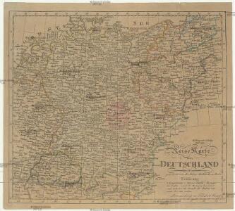
Reise Karte von Deutschland
Evropa střední Julius, E. Vieweg, Friedrich Friedrich Vieweg
Germany, Austria, Bohemia.
1 : 2600000 Cary, John, ca. 1754-1835
Germania Antiqua.
1 : 2300000 Robert de Vaugondy, Gilles, 1688-1766
Carte generale di lutta l Alemagna, e paesi circonuicini
Evropa střední
La Germanie, 275 de J.C.
1 : 6300000 Houze, Antoine Philippe
La Germanie 511 a 741.
1 : 6300000 Houze, Antoine Philippe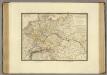
Empire d'Allemagne, Hongrie, Gallicie, Prusse, Provinces-Unies de Pays-Bas; en 1789.
1 : 3500000 Brue, Adrien Hubert, 1786-1832
GERMANIAE | VETERIS | typus.
[Amsterdam : Joan Blaeu]
Nova totius Germaniae descriptio
1 : 3640000 Evropa střední Hofmann, Johann Johann Hofman[n]
Germania Vindelicia Rhaetia Noricum et Pannonia
Germanien, Pannonien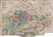
Mitteleuropa Bodenkarte
1 : 6000000 Mitteleuropa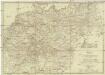
Neueste Post Karte von Deutschland und dessen angrenzenden Länder
Evropa střední Jättnig, Karl Simon Schropp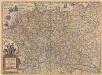
Germaniae nova et accurata delineatio [Karte], in: Novus atlas absolutissimus, Bd. 2, S. 13.
1 Karte aus Atlas Janssonius Offizin
Carte générale d'Allemagne
1 : 3760000 Evropa střední Mentelle, Edme Tardieu, Pierre François
General Charte von Teutschland mit Angabe aller Post-Strassen von Paris bis Warschau, und von Triest bis Stralsund
1 : 1760000 Evropa střední Güssefeld, Franz L. Geograph. Institut
Die großen Friedensschlüsse I (1648 - 1721). 1. Westfälischer Friede 1648
1 : 20000000 Mitteleuropa Westfälischer Friedenskongress
Deutschland.
1 : 3400000 Flemming, Carl
Fürstentum Reuß-Ebersdorf im Deutschen Bund 1820
Reuß-Ebersdorf, Deutschland Kunz, Andreas ; Moeschl, Joachim Robert
Germania [Karte], in: Gerardi Mercatoris Atlas, sive, Cosmographicae meditationes de fabrica mundi et fabricati figura, S. 327.
1 Karte aus Atlas Mercator, Gerhard Montanus, Petrus
(Villes Anseatiques)
1 : 2900000 Dangeau, abbe de, 1643-1723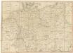
Neueste Post-Karte von Deutschland und den angrenzenden Laendern
1 : 1700000 Maďarsko Mollo, Tranquillo T. Mollo
Deutschland ́s Eisenbahnen und Strassen - Netz

Mittelbach's Automobilkarte von Mitteleuropa
1 : 1500000 Evropa střední Mittelbach's Verlag
Germany.
1 : 5200000 Darton, William
Á Német szövetség
1 : 4930000 Evropa střední Biller, Bernhard Bucsánszky Alajos'
Nationalitäts-Karte von Deutschland
Německo Kiepert, Heinrich Homann, Johann Baptist Geograph. Institut
B.Z. - Karte von Oesterreich

Germania Augustiniana
1 : 3700000 Mollova mapová sbírka Seutter, Matthäus Seutter, Matthäus
Germany.
1 : 9000000 Fenner, Rest.