Maps of okres Plzeň-sever

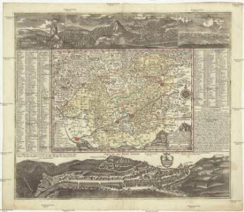
Accurate Abbildung der Statt Kayser Carlsbad nach doppelten Prospect und geograph. Situation in Böhmen in dem Elnbogner Crais gelegen samt angränzender Gegend und Landschafften
1 : 160000 Karlovy Vary (Česko) Seutter, Matthäus von Matthaeo Seutter
Accurate Abbildung der Statt Kayser Carlsbad nach doppelten Prospect und geograph. Situation in Böhmen in dem Elnbogner Crais gelegen samt angränzender Gegend und Landschafften
1 : 160000 Karlovy Vary (Česko) Seutter, Matthäus von Matthaeo Seutter
Generální mapa ČSR

Generální mapa Protektorátu Čechy a Morava

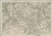
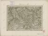
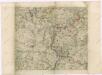
Charte vom Pilsner Kreise des Königreiches Böheim
1 : 243000 Plzeň-oblast (Česko) Kreibich, František Jakub Jindřich Enders, C. W. C.W. Enders
Charte vom Pilsner Kreise des Königreiches Böheim
1 : 243000 Plzeň-oblast (Česko) Kreibich, František Jakub Jindřich Enders, C. W. C.W. Enders
Charte vom Pilsner Kreise des Königreiches Böheim
1 : 243000 Plzeň-oblast (Česko) Kreibich, František Jakub Jindřich Enders, C. W. C.W. Enders
Charte vom Pilsner Kreise des Königreiches Böheim
1 : 243000 Plzeň-oblast (Česko) Kreibich, František Jakub Jindřich Enders, C. W. C.W. Enders
Charte vom Pilsner Kreise des Königreiches Böheim
1 : 260000 Plzeň-oblast (Česko) Kreibich, František Jakub Jindřich C. W. Enders
Charte vom Pilsner Kreise des Königreiches Böheim
1 : 243000 Plzeň-oblast (Česko) Kreibich, František Jakub Jindřich Enders, C. W. C.W. Enders
Charte vom Pilsner Kreise des Königreiches Böheim
1 : 260000 Plzeň-oblast (Česko) Kreibich, František Jakub Jindřich C. W. Enders
Charte vom Pilsner Kreise des Königreiches Böheim
1 : 243000 Plzeň-oblast (Česko) Kreibich, František Jakub Jindřich Enders, C. W. C.W. Enders
Charte vom Pilsner Kreise des Königreiches Böheim
1 : 243000 Plzeň-oblast (Česko) Kreibich, František Jakub Jindřich Enders, C. W. C.W. Enders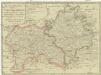
Regni Bohemiae Circuli Satecensis et Cubitensis
1 : 200000 Loket-oblast (Sokolov, Česko) Müller, Johann Christoph Homannianorum Heredum
Generalkarte der Bezirkshauptmannschaft Podersam
1 : 220000 Podbořany-oblast (Česko) Wagner, Jan Eduard Mareš, František F. Kytka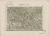
II. vojenské mapování 12
1 : 144000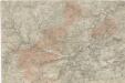
Spezial Karte von Böhmen
Special - Karte des Koenigreiches Boehmen
II. vojenské mapování 18
1 : 144000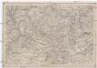
Umgebungen von Pilsen
1 : 750000 Plzeň (Česko : oblast) Kiss, Josef K. k. militär-geographisches Institut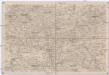
Umgebungen von Lubenz
1 : 750000 Lubenec (Česko : oblast) K. k. militär-geographisches Institut
Charte vom Saazer Kreis im Königreiche Böhmen
Žatec-oblast (Louny, Česko) Berghaus, Heinrich Karl Wilhelm Kutschera, E. E. Kutschera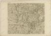
Mappa geographica regni Bohemiae in duodecim circulos divisae ...
Müllerova mapa Čech
1 : 132000
Charte der zwischen der K. Hauptstadt Prag und der K. Kreisstadt Pilsen beabsichtigten Eisenbahn
1 : 75000 West-Blatt [Verlagsname nicht ermittelbar]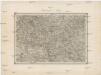
Umgebungen von Lubenz
Lubenec-oblast (Česko) Kiss, Josef K. u. k. Militärgeographisches Institut
Turistická mapa okolí Plzně
1 : 75000 Plzeň-oblast (Česko) Vojenský zeměpisný ústav
Circuli Pilsnensis
Rukopisná barevná mapa panství severně od Plzně - plaského, kaceřovského, dolnobělského a krašovského. Rámována ozdobným rámem, doplněným v levých rozích a po pravé straně vedutami významných lokalit (zámek Plasy, dvůr Hubenov, zámek Bělá, zámek Kaceřov, klášter Týnec (Mariánská Týnice), dvůr Býkov, zámek Krašov). Mapa vznikla pravděpodobně po zrušení plaského kláštera v r. 1785.
Monumenta Cartographica Bohemiae II.: Müllerova mapa