Maps of Turkey
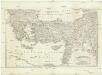
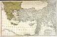
[Balkán a Malá Asie]
1 : 2850000 Balkánský poloostrov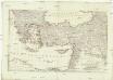
[Balkán a Malá Asie]
1 : 2850000 Balkánský poloostrov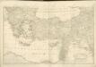
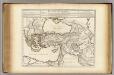
Dritter Theil der Karte von Europa welcher das südliche Russland Polen und Ungarn die europæische, und beinahe die ganze asiatische Türkei enthælt, 2
1 Blatt : 54 x 84 cm F.A. Schrämbl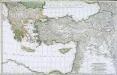
Troisième partie de la carte d'Europe contenant le midi de la Russie, la Pologne et la Hongrie, la Turquie y compris celle d'Asie presqu'entière, 2
1 Blatt : 53 x 84 cm chez l'auteur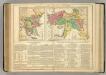
Turkey.
1 : 7800000 Lavoisne, M.
Colonia romana, Tabula geographica provinciarum et urbium.
1 : 5000000 L'Isle, Guillaume de, 1675-1726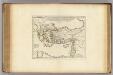
Colonia Romana, Tabula Geographica Provinciarum et Urbium.
1 : 5000000 L'Isle, Guillaume de, 1675-1726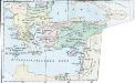
Latein. Kaisertum in Constantinopel und die christlichen Reiche im Orient 1204
Lateinisches Kaiserreich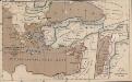
Das lateinische Kaiserthum in Constantinopel und die christlichen Reiche im Orient 1204
Lateinisches Kaiserreich , Kreuzfahrerstaaten
Tabula geographica ad acta aposto
Středozemní moře-oblast východní Berka, Jan
Peregrinationis divi Paulitypus Corographicus
Retraite des Dix Mille Tabula.
1 : 5000000 L'Isle, Guillaume de, 1675-1726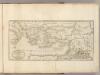
Countries ... Apostles Travelled: in propagating Christianity.
1 : 6000000 Carey, Mathew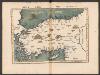
Tabula Nova Asie Minoris [Karte], in: Claudii Ptolemei viri Alexandrini mathematice discipline philosophi doctissimi geographie opus [...], S. 269.
1 Karte aus Atlas Waldseemüller, Martin [und Ptolemaeus, Claudius] Übelin, Georg
Turkish Empire, Greece, Romania.
1 : 6969600 Letts, Son & Co.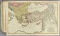
Mediterranean E.
1 : 2850000 Faden, William, 1750?-1836
A new map shewing all the severall countries, cities, towns and other places mentioned in the New Testament [1 - in Greece Cyprus, Asia and parts adjoining; 2 - in Italy, Mesopotamia &c.; 3 - in the Holy Land and parts adjoining.]
from A new sett of maps both of antient and present geography : wherein not only the latitude and longitude of many places are corrected according to the latest observations, but also the most remarkable differences of antient and present geography may be quickly discern'd by a bare inspection or comparing of correspondent maps, which seems to be the most natural and easy method to lead young students (for whose use the work is principally intended) unto a competent knowledge of the geographical science : together with a geographical treatise particularly adapted to the use and design of these maps / by Edward Wells, M.A. and student of Christ-Church, Oxon.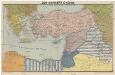
Der vordere Orient
1 : 2750000 Blízký východ List & von Bressensdorf
Tabula Prima Asie [Karte], in: Claudii Ptolemei viri Alexandrini mathematice discipline philosophi doctissimi geographie opus [...], S. 193.
1 Karte aus Atlas Waldseemüller, Martin [und Ptolemaeus, Claudius] Übelin, Georg
Retraite des dix mille
1 Karte : Kupferdruck ; 37 x 55 cm, Bildgrösse 45 x 57 cm L'Isle; Buache apud auctorem in ripâ vulgo dictâ la rue des Noyers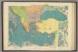
E. Mediterranean.
1 : 5000000 Philip, George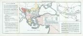
Nr. 15. Der russisch-türkische Krieg 1877/78
Balkanhalbinsel Russisch-Russisch-Türkischer Krieg <1877-1878>
Schul-Atlas für die alte Erdbeschreibung : zur allgemeinen Schul-encyclopädie gehörig
J. H. Campe Zusammensetzung und Zeichnung von [...] Dufour, unter Leitung von Heusinger ; gestochen von Frentzel. Braunschweig : Schulbuchhandlung
[Klein-Asien & Syrien, Nebst den Westlichen Theilen von Armenien, Kurdistan & Mesopotamien]
Handatlas über alle Theile der Erde und über das Weltgebäude Stieler, Adolf Justus Perthes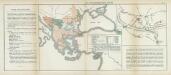
Nr. 11. Der russisch-türkische Krieg 1877/78
Balkanhalbinsel Russisch-Russisch-Türkischer Krieg <1877-1878>
Tabula geographica Cyri et Xenophontis expeditionem illustrans
1 : 8000000 Annotatie: Historische kaart van de tocht van Xenophon en de "Tienduizend" door het Perzische Rijk (401 v.Chr.) Leiden : Brill
Klein-Asien & Syrien nebst den westlichen Theilen von Armenien, Kurdistan & Mesopotamien
Hand-Atlas über alle Theile der Erde und über das Weltgebäude Stieler, Adolf Justus Perthes
ASIA MINOR, SYRIA, ARMENIA, MESOPOTAMIA, ASSYRIA, Palestina
1 : 7000000 Arménie Renner Kleinknecht Bibliographisches Institut
![[Balkán a Malá Asie]](https://images-2.georeferencer.com/images/iiif/000788394175/full/,300/0/native.jpg)

