Maps of City of St. Petersburg
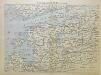
Plan Sarskago Sjela
Puškin (Rusko) Kuvakin, J.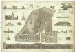
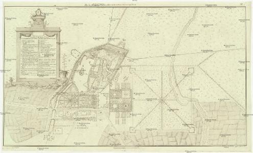
Plan du jardin et vue de differens batimens de sa majesté imperiale, a Zarsko Zelo
Puškin (Rusko) Bush, Joseph Bush, Jean
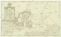
Plan Carskago Sela
Russland St. Petersburg Zarkskoje Selo Stadtviertel Adressbuch
[St. Petersburg und Umgegend]
1 : 600000 Sankt Petersburg, Umland
St. Petersburg mit Umgebung
1 : 150000 Sankt Petersburg, Umland
<Karta mesta zanimaemago Sanktpeterburgom : v tom vide v kakom onoe nakhodilos za god do osnovanii͡a goroda; sostavlena dli͡a panoramy S. Peterburga, 1834>
s.n.
15. Moscow. Leningrad. (Vicinity). The World Atlas.
1 : 250000 USSR (Union of Soviet Socialist Republics).
<Topograficheskai͡a karta okruzhnosti Sanktpetersburga : Ispravlennaia 1817 goda>
1 : 42000 Russia. Armii͡a. Voenno-topograficheskoe depo. Voenno-Topograficheskom Depo pri Glavnom Shtabie ego Impertorskafo Velichestva
Okrestnosti S. Peterburga
Russland St. Petersburg Umland Il'in', N.
Umgebung von St. Petersburg
St. Petersburg, Umland
[Okrestnosti Sankt-Peterburga]
1 : 85000 Petrohrad-oblast (Rusko)
Ladožskoje ozero i Finskij zalip s prilěžaščimi městami
Finský záliv Seutter, Matthäus Matthaeus Seutter
Ingermanlandiae seu Ingriae novissima tabula / luci tradita per Homannianos Heredes
1 : 390000 1 Karte : Kupferdruck ; 46 x 55 cm Rostovčev, Aleksej Ivanovič Homännische Erben
Ingermanlandiae seu Ingriae novissima tabula
1 : 390000 Petrohrad (Rusko) per Homannianos heredes
Der Kampf um Petrograd (Oktober 1919)
Russland (Nordwest) Russischer Bürgerkrieg <1917-1921>
INGRIA.
[Amsterdam : Joan Blaeu]
St. Petersburg, Tichwin
1 : 750000 Petrohrad (Rusko) K. u. k. Militärgeographisches Institut
Nova et accurata delineatio Ingriae et Careliae cum magna parte sinus Finnici et lacus Ladogae, nec
1 : 610000 1 Karte : Kupferdruck ; 55 x 47 cm Seutter, Matthäus [Matthäus Seutter]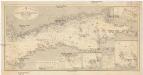
Ostsee
1 : 400000 Baltské moře Reichs-Marine-Amt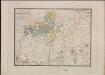
Ethnographische Karte des St. Petersburgischen Gouvernements
Gouvernement Sankt Petersburg Ethnische Gruppe, Bevölkerung Keppen, Petr I.
Nova et accurata delineatio Ingriae et Careliae cum magna parte Sinus Finnici et Lacus Ladogae, nec non insularum adjacentium
1 : 1210000 Finsko Seutter, Matthäus Matthaeus Seutter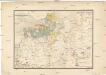
Etnographische Karte des St. Petersburgischen Gouvernements
1 : 1300000 Petrohrad-oblast (Rusko) Koeppen, P. von K. Akademie der Wissenschaften zu St. Peterburg
Province de St. Petersbourg
1 : 840000 [St. Petersbourg] : [A. Iljin]
General'naja Karta Sanktpeterburgskoj Gubernii
1 : 1125000 composé et gravée par Piadicheff les leteres grav. M. Iwanoff St. Petersbourg, [s.n.]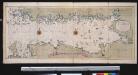
Nieuwe afteekening van de Finlandse Golff
Gulf of Finland Abraham Maas Gerard van Keulen
Nieuwe kaart van de Finnissche Golf benevens de omliggende provintien : naar de beste kaarten en sterrekundige waarnemingen geteekend in 't Konigl. Landmeeters Comtoir te Stockholm
1 : 1200000 C. van Baarsel sculp. te Amsterdam : bij J. Covens en Zoon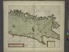
The coast of LYF LAND and East FINLAND from Wolf to Wybourgh and soto Elsenvos
from The sea-atlas : containing an hydrographical description of most of the sea-coasts of the known parts of the world.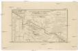
Karta napravlenija železnoj dorogi šossei i vodjanych soobščenij meždu S. Peterburgom i Moskvoju
1 : 1300000 Moskva-oblast (Rusko) Al'tman, I. Flerov, V. v Zavedenii kongrevskoj chromotipii F. Tuma
Estland, Lettland und Nordwestrußland
1 : 2500000 Estland, Lettland