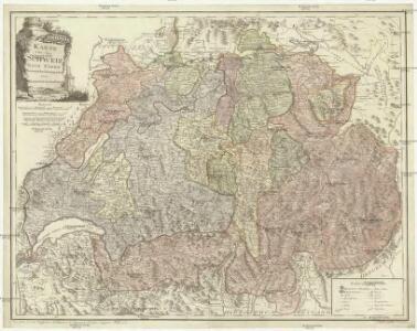
Maps of Switzerland

Karte von der Schweiz
1 : 44000 Švýcarsko Reilly, Franz Johann Josef von Faden, William Reilly'schen Landkarten und Kunstwerke Verschleis Komptoir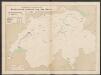
Graphisch-statistischer Atlas der Schweizerischen Normalbahnen
1 : 500000 Historische Entwicklung der Netze 1855 Schweizerische Nordostbahn Lithographie Druck & Verlag von Hofer & Burger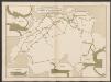
Graphisch-statistischer Atlas der Schweizerischen Normalbahnen
1 : 500000 Leistungen des Betriebsmaterials 1881 Schweizerische Nordostbahn Lithographie Druck & Verlag von Hofer & Burger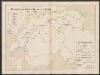
Graphisch-statistischer Atlas der Schweizerischen Normalbahnen
1 : 500000 Historische Entwicklung der Netze 1881 - 1882 Schweizerische Nordostbahn Lithographie Druck & Verlag von Hofer & Burger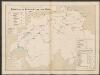
Graphisch-statistischer Atlas der Schweizerischen Normalbahnen
1 : 500000 Historische Entwicklung der Netze 1875 Schweizerische Nordostbahn Lithographie Druck & Verlag von Hofer & Burger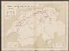
Graphisch-statistischer Atlas der Schweizerischen Normalbahnen
1 : 500000 Historische Entwicklung der Netze 1855 - 1882 Schweizerische Nordostbahn Lithographie Druck & Verlag von Hofer & Burger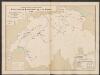
Graphisch-statistischer Atlas der Schweizerischen Normalbahnen
1 : 500000 Historische Entwicklung der Netze 1865 Schweizerische Nordostbahn Lithographie Druck & Verlag von Hofer & Burger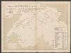
Graphisch-statistischer Atlas der Schweizerischen Normalbahnen
1 : 500000 Historische Entwicklung der Netze 1860 Schweizerische Nordostbahn Lithographie Druck & Verlag von Hofer & Burger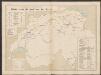
Graphisch-statistischer Atlas der Schweizerischen Normalbahnen
1 : 500000 Historische Entwicklung der Netze 1880 Schweizerische Nordostbahn Lithographie Druck & Verlag von Hofer & Burger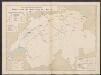
Graphisch-statistischer Atlas der Schweizerischen Normalbahnen
1 : 500000 Historische Entwicklung der Netze 1870 Schweizerische Nordostbahn Lithographie Druck & Verlag von Hofer & Burger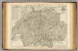
Suisse ou sont les Cantons.
1 : 514000 Merveilleux, David Francois de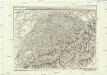
Carte generale de la Suisse suivant ses nouvelles divisions, qui conprennent les ci-devant 13 cantons, leurs alliés et sujets, et forment actuellement la republique Helvetique une et indivisible
1 : 500000 Švýcarsko Mechel, Christian von Chretien de Mechel
Carte générale de la Suisse suivant ses nouvelles divisions, qui comprennent les ci-devant XIII. cantons, leurs alliés et sujets, et forment actuellement la République Helvétique une et indivisible
1 : 510000 Švýcarsko Mechel, Christian von Chretien de Mechel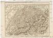
Carte generale de la Suisse suivant ses nouvelles divisions, qui comprennent les ci-devant XIII. cantons, leurs alliés et sujets, et forment actuellement la Republique Helvetique une et indivisible
Švýcarsko Mechel, Christian von Ludvík Chretien de Mechel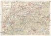
Touristenkarte der Schweiz
1 : 900000 Interlaken (Švýcarsko) Kümmerly & Frey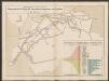
Graphisch-statistischer Atlas der Schweizerischen Normalbahnen
1 : 500000 Ursprüngliche, bis Ende 1881 berechnete Anlagekosten nach Strecken Schweizerische Nordostbahn Lithographie Druck & Verlag von Hofer & Burger
Carte genérale de la Suisse, oder, Die Helvetische Republik in XXII Cantone eingetheilt
1 : 525000 1 Karte Joh. Walch bei Joh. Walch, Augsburg
<<Der>> Helvetischen Republik neue Cantons und Districts Eintheilung
1 : 630000 1 Karte dem Vollziehungs-Directorium gewiedmet von Wilhelm Haas dem Sohne im Augstmonat 1798 Haas, Basel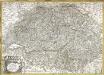
Carte de la republique des Suisses leurs sujets et alliées
1 Karte : Kupferdruck ; 46 x 65 cm Haumann; Mondhare chez Mondhare rue S. Jacques
Telegraphenkarte der schweizerischen Eisenbahnen
1 : 400000 [s.n.]
Nouvelle carte de la Suisse dans laquelle sont exactement distingués les treize cantons, leurs alliés et leurs sujets
1 Karte dréssée sur les mémoires les plus corrects et assujettie aux observations astronomiques [par William Faden] chez W. Faden, Charing Cross, Londre
Nova Helvetiæ tabvla
1 Karte : Kupferdruck ; 33 x 46 cm Hondius ex officina Iudoci Hondii F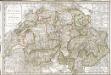
Carte de la Suisse, ou l'on a marqué les routes suivies par M.re Wil. Coxe, dans ses quatre voyages en 1776, 1779, 1785 et 1786
1 Karte : Kupferdruck ; 48 x 72 cm Coxe; Picquet s.n.
Karte der Verbreitung des Stolzeschen Stenographie-Systems in der Schweiz
1 : 1080000 1 Karte R. Gross gez. ; Lith. v. Hänsler & Schellenberg, Zürich [Verlag des Allgem. schweiz. Stenographenvereins], [Wetzikon]
Switzerland.
1 : 1330560 Tallis, J. & F.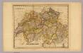
Switzerland.
1 : 1180000 DeSilver, Robert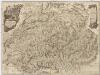
Neue Karte von der Schweiz oder Helvetien in die XIII Eidgenossenschaften, ihre Bundsverwandten und Unterthanen eingetheilt
1 : 543100 Švýcarsko Faden, W. F.A. Schraembl
Carte physique & routière de la Suisse
1 : 500000 1 Karte dressés d'après des meilleurs matériaux par Jean Goll ; gravée par [Henri Louis Nicolas] Duval & [Rinaldo] Bressanini Henri Fuessli & Cie., Zürich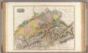
Swisserland.
1 : 500000 Pinkerton, John, 1758-1826