Maps of Metropolitan France

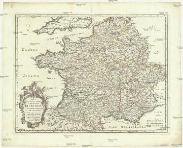
Nova et esatta tavola del regno di Francia
1 : 2800000 Francie Sanson, Nicolas De Rossi, Giovanni Giacomo Gio. Iacomo de Rossi
Gallia Vulgo La France [Karte], in: Novus atlas absolutissimus, Bd. 4, S. 31.
1 Karte aus Atlas Janssonius Offizin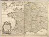
Le royaume de France
1 : 10300000 Francie Sanson, Guillaume Cordier, Louis chez H. Iaillot

Gallia
1 : 3800000 Alpy francouzské Spruner, Karl von Justus Perthes
France.
1 : 5000000 Carey, Mathew
France.
1 : 4900000 Carey, Mathew
Carte du royaume de France
1 Karte : Kupferdruck ; 32 x 40 cm Bourgoin chez Bourgoin graveur rue de la Harpe vis-a-vis le passage des Jacobins a côté du caffé de Condé
Gallia antiqua
1 Karte : Kupferdruck ; 23 x 27 cm Delamarche; Delahaye C. F. Delamarche
Gallia antiqua
1 Karte : Kupferdruck ; 45 x 44 cm, Bildgrösse 46 x 58 cm Anville; Bek in officina Weigelio-Schneideriana
Carte physique ou géographie naturelle de la France
1 Karte : Kupferdruck ; 39 x 46 cm Buache Philippe Buache
Gallia antiqua
1 Karte : Kupferdruck ; 46 x 55 cm Anville; Santini; Remondini apud Franc.m Santini, chez M. Remondini
Gallia antiqua in provincias et populos divisa
1 Karte : Kupferdruck ; 47 x 53 cm Robert de Vaugondy; Sanson s.n.
Le royaume de France
1 : 2400000 Francie Walch, Johann Witt, F. M. par Jean Walch
Le royaume de France
1 : 2400000 Francie Walch, Johann par Jean Walch
Le royaume de France
1 : 2400000 Francie Walch, Johann par Jean Walch
Le royaume de France
1 : 2400000 Francie Walch, Johann par Jean Walch
Le royaume de France
1 : 2400000 Francie Walch, Johann Will, Johann Martin par Jean Walch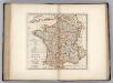
France Divided into Circles and Departments.
1 : 3300000 Carey, Mathew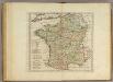
France Divided into Circles and Departments.
1 : 3300000 Carey, Mathew
France Divided into Circles and Departments.
1 : 3421440 Carey, Mathew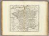
France Divided into Circles and Departments.
1 : 3484800 Carey, Mathew
France Divided into Circles and Departments.
1 : 3484800 Carey, Mathew
Gallia Vetus in Regiones IV, in Provincias XVII.
1 : 4300000 Vivien de St Martin, L.
Totius regni Galliae sive Franciae tabula
1 : 2430000 Francie Homann, Johann Baptist a Ioh. Bapt. Homanno
TOTIUS REGN[I] GALLIAE SIVE FRANCIAE TABULA
1 : 2500000 Francie Homann, Johann Baptist a Ioh. Bapt. Homanno
Totius regni Galliae sive Franciae tabula
1 : 2500000 Francie Homann, Johann Baptist a Ioh. Bapt. Homanno
Totius regn[i] Galliae sive Franciae tabula
1 : 2430000 Francie Homann, Johann Baptist a Ioh. Bapt. Homanno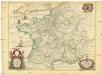
Les postes qui trauersent la France
1 : 3000000 Francie Sanson, Guillaume N. Sanson
Tres nouvelle carte du royaume de France
1 Karte : Kupferdruck ; 43 x 55 cm Cassini de Thury; Rizzi-Zannoni; Dorn Homännische Erben
Tres nouvelle carte du royaume de France
1 Karte : Kupferdruck ; 43 x 55 cm Cassini de Thury; Rizzi-Zannoni; Dorn Homännische Erben
Tres nouvelle carte du royaume de France
1 Karte : Kupferdruck ; 43 x 55 cm Cassini de Thury; Rizzi-Zannoni; Dorn Homännische Erben
Tres nouvelle carte du royaume de France
1 Karte : Kupferdruck ; 43 x 55 cm Cassini de Thury; Rizzi-Zannoni; Dorn Homännische Erben
Tres nouvelle carte du royaume de France
1 Karte : Kupferdruck ; 43 x 55 cm Cassini de Thury; Rizzi-Zannoni; Dorn Homännische Erben
Tres nouvelle carte du royaume de France
1 Karte : Kupferdruck ; 43 x 55 cm Cassini de Thury; Rizzi-Zannoni; Dorn Homännische Erben
Tres nouvelle carte du royaume de France
1 Karte : Kupferdruck ; 43 x 55 cm Cassini de Thury; Rizzi-Zannoni; Dorn Homännische Erben