Maps of Rhein-Pfalz-Kreis

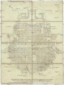
Grundriss des innern Raums der Churf. Pfalz. Resid. Stadt Mannheim
Mannheim (Německo) Dewarat, Peter
Der Hafen zu Mannheim
1 : 2000 Moutoux, Jules [Verlagsort nicht ermittelbar]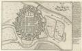
Plan von Manheim :
1 : 13000 Mollova mapová sbírka Bodenehr, Gabriel Bodenehr, Gabriel
Hodierna Sedes Electoris Palatini Manheimium
1 : 8000 Mollova mapová sbírka Homann, Johann Baptist Homann, Johann Baptista - dědici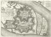
Mannheim
Mollova mapová sbírka Merian, Matthaeus Merian, Matthäus
Manheimium
Mannheim (Německo) Seutter, Matthäus Adrichem, Christiaan van per Matthaeum Seutter
Manheimium
Mannheim (Německo) Seutter, Matthäus Furlanetto, Lodovico per Matthaeum Seutter
Manheimium
Mollova mapová sbírka Seutter, Matthäus Seutter, Matthäus
Meßtischblatt 6516 : Mannheim-Süd, 1944
1 : 250000 Mannheim-Süd. - Aufn. 1910 (Baden 1933), hrsg. 1914, bericht. 19. - 1:25000. - Wiesbaden: Hauptvermessungsabteilung XI, 1944. - 1 Kt.
Meßtischblatt 25 : Ludwigshafen, 1936
1 : 250000 Ludwigshafen. - Aufn. 1910, Ausg. 1914, Erkundung 1935, bericht. 1936. - 1:25000. - [München], 1936. - 1 Kt.
Meßtischblatt 6516 : Mannheim, 1881
1 : 250000 Mannheim. - 1:25000. - Leipzig: Giesecke & Devrient, 1881. - 1 Kt.
Manheimium munitißimus oppidum et hodierno die residentia electoris palatini, ad confluentes Rheni et Nicri, juxta recentißimam delineationem
Mannheim (Německo) Seutter, Matthäus per Matthaeum Seutter
Mannheim

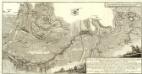
Vorstellung der Linie u[nd] Inondation von Bruchsahl bis Ketsch
1 : 60000 Mollova mapová sbírka Riecke, Gustav Friedrich Homann, Johann Baptista - dědici
Le Flambeau de la Guerre Allumee au Rhin
Mollova mapová sbírka Delisle, Guillaume Schenk, Peter II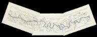
[Lauf des Rheins von Neuburg bis unterhalb Mannheim im Anfange des Jahres 1837] : Tab. 1: Hydrographische Charte vom Lauf des Rheins v. Neuburg bis Sondernheim die im Jahre 1817 angefangen Rectification desselben enthaltend. 2: Hydrographische Carte vom Lauf des Rheins von Sondernheim bis Otterstatt mit Rücksicht auf die Rectification desselben . 3: Hydrographische Carte vom Lauf des Rheins mit Rücksicht auf die Rectification desselben : Distrikte v. Waldsee bis an die Hessischen Grenze
1 : 80000 [S.l.] : Grosh. Bad. Landw. Wochenblatt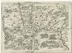
Geographica Provinciarum Sveviae Descriptio =
Mollova mapová sbírka Hurter, Johann Christoph Bodenehr, Gabriel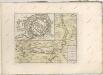
Carte von Linie und Innondation, von Bruchsal bis Kethsch, woselbst die Innondation in Rhein fließet.
1 : 65000 Mollova mapová sbírka Riecke, Gustav Friedrich Bodenehr, Gabriel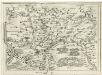
Geographica Provinciarum Sveviae Descriptio =
Mollova mapová sbírka Hurter, Johann Christoph Bodenehr, Johann Georg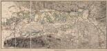
[Topographische Charte der Gegend zwischen Rhein, Neckar und Mayn]
Meister, G.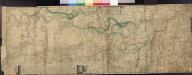
Le Cours Du Rhin Depuis Spire juisqu'à Mayence, les marches et Contremarches de l'Armée Francoise et les Camps y sont marqués Come aussi de l'Armée Alliée du coté du Main l'ann 1743 avec la Situation de l'Odewwald et du Berg Straass
Denis, Ferdinand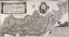
Accurate Special-Charte der Gegend des Rheins, von Ettlingen, Carls Ruhe, Philippsburg, Bruchsal, bis Mannheim, etc. Entworffen
Riecke, Gustav Friedrich; Ostertag, Heinrich Jonas; Cöntgen, Bartolomäus Anton Brönner
Territorium Seculare Episcopatus Wormatiensis Tabula Geographica
1 : 130000 Mollova mapová sbírka Homann, Johann Baptist Homann, Johann Baptista - dědici
Karte eines Theils des ehemaligen Departement des Donnersberges nach Cantons eingetheilt
1 : 178300 Mohuč (Německo : oblast) Veil
Erpach Comitatus
1 : 170000 Mollova mapová sbírka Keere, Pieter van den Schenk, Peter I
Erpach Comitatus
1 : 170000 Mollova mapová sbírka Keere, Pieter van den Janssonius, Johannes I
Section Worms, uit: Charte von dem Grossherzogtum Hessen und dem Herzogtum Nassau / trigonometrisch aufgenommen und hrsg. von C.L.P. Eckhardt
1 : 200000 titelvariant: Karte von Hessen und Nassau Eckhardt, C. L. P Darmstadt : Joh. Wilh. Heyer
Partie du Cours du Palatinat du Rhin Levesché de Spire et de Worms les Comté de Spanheim et de Linange levée Sur les lieu
1 : 160000 Mollova mapová sbírka Baillieul, Gaspard Bailleul, Gaspard