Maps of Romania
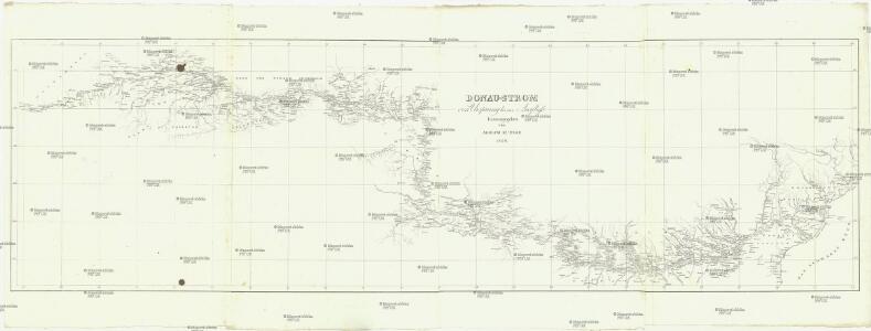
Donau-Strom
Dunaj Kunike, Adolf Bedřich Adolph Kunike
Danubius Qvotqvot in Ipsum se Exonerant Fluviis Auctus
1 : 4700000 Mollova mapová sbírka Marsili, Luigi Ferdinando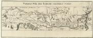
Die Donau, der Fürst aller Europaeischen Flüsse
Mollova mapová sbírka Hoffmann, Johannes Hoffmann, Johann
Danubius a fonte usque ad ostia
1 : 11100000 1 Kt. in 2 Teilen auf 1 Bl. : Kupferdruck ; 34 x 6 cm, je Teil 17 x 6 cm Weigel, Johann Christoph [Johann Christoph Weigel]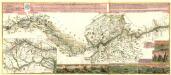
Nev Accurat, Vnd Noch Niemalen In Offentlicher Expression Heravs Gegebener Practicirter Donav Strohm
Mollova mapová sbírka
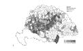
Magyarország hegy- és vizrajzi térképe
1 : 3500000 Karpaty (pohoří : oblast) Homolka, Josef Posner Károly Lajos és Fia
Provincia Austriaca Societatis Iesu
Evropa jihovýchodní Seutter, Matthäus Mayr, Johann Baptist Matthäus Seutter
Provincia Austriaca Societatis Iesu
Evropa jihovýchodní Seutter, Matthäus Kappus, Marcus Antonius a Matthaeo Seutter
Suisse.
1 : 840000 Garnier, F. A., 1803-1863
Die Wahlbezirke nach 1878
Ungarn Wahlbezirk
[Uhry]
1 : 914000 Maďarsko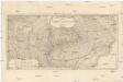
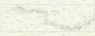
Carte comprenant le cours du Danube
1 : 1750000 Dunaj-delta (Rumunsko a Ukrajina) Dupuis, L. A.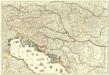
Le Cours du Danube
1 : 1800000 Mollova mapová sbírka Placide de Sainte-Hélène Berey, Charles Amadeus de
Ungarn mit seinen Nebenländern und Galizien
1 : 1600000 Dalmácie (Chorvatsko)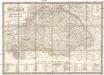
Karte von Königreich Ungarn und den zugehörigen Nebenländern
1 : 1887000 Maďarsko Schmitfeldt, Georg Lipský, Ján Florian Mollo

Skelett für die Special-Karte des Königreichs Ungarn mit dem Grofsfürstenthume Siebenbürgen, der Königreiche Croatien u[nd] Slavonien, dann der k.k. Militärgrenze
1 : 75000 Chorvatsko K. u. k. Militärgeographisches Institut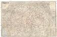
Magyarország és Horvát-Szlavonország
1 : 900000 Evropa východní Eggenberger-féle könyvkereskedés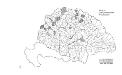
Die konservativen Wahlbezirke
Ungarn Wahlbezirk, Wahlverhalten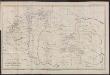
Übersichtskarte der Verbreitung der deutschen Ansiedlung und des deutschen Rechts in Ungarn, Siebenbürgen, Kroatien und Slavonien bis 1763 und in der Walachei und Moldau bis 1774
Ungarn Rumänien Deutsche Ostsiedlung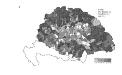
Die Bezirke der Tendenz "A" vor 1875
Ungarn Wahlbezirk, Wahlverhalten
Maximi totius Europae Fluminis Danubii Cursus per Germaniam Hungariamque
1 : 1200000 Mollova mapová sbírka Janssonius, Johannes Janssonius, Johannes I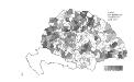
Die Bezirke der Tendenz "B" nach 1875
Ungarn Wahlbezirk, Wahlverhalten
Tabula generalis regni Hungariae, Croatiae et Slavoniae nec non magni principatus Tranylvaniae
1 : 1400000 Chorvatsko Lipský, Ján Festetis, Georgio
Tabula generalis regni Hungariae, Croatiae et Slavoniae, nec non magni principatus Transylvaniae
1 : 1400000 Chorvatsko Lipský, Ján Festetis de Tolna, Georgio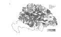
Die Bezirke der Tendenz "B" vor 1875
Ungarn Wahlbezirk, Wahlverhalten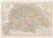
Orts- und Strassenkarte des Königreiches Ungarn
1 : 1296000 Chorvatsko Steinhauser, Anton Artaria
Die Bezirke der Tendenz "A" nach 1875
Ungarn Wahlbezirk, Wahlverhalten
Hongrie. Coal Resources of the World.
1 : 1724100 de Pann, Charles