Maps of Appennini

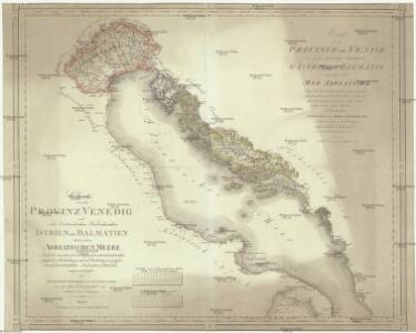
Charte von der Provintz Venedig und den oestereichischen Küstenlaendern Istrien und Dalmatien dann von dem Adriatischen Meere
1 : 1540000 Benátsko (Itálie) Liechtenstern, Joseph Marx von Hohlgartt, Ludwig Grafen von Kunst und Industrie Comptoirs
Nette afteekening van de Golf van Venetia vertoonende alle desselfs haavenen reede en baije in grood besteck
Italy Gerard van Keulen
Carte hydrographique du golphe de Venise
1 Karte : Kupferdruck ; 58 x 85 cm Bellin s.n.
Das Adriatische Meer
Stieler's Hand-Atlas Stieler, Adolf bei Justus Perthes
[Das Adriatische Meer]
Hand-Atlas über alle Theile der Erde nach dem neuesten Zustande und über das Weltgebäude Stieler, Adolf bei Justus Perthes
Plastická mapa Italie a přímořských zemí rakouských
Itálie Batěk, J. Emil Šolc
Vzducholodí přes Italii a Dardanely
Dardanely (Turecko : průliv) Melantrich
Le Golfe De Venise, Avec ses Principaux Caps. Promontoires, & Ports de Mer. [Karte], in: Atlas nouveau, contenant toutes les parties du monde [...], Bd. 2, S. 238.
1 Karte aus Atlas Sanson, Nicolas Jaillot, Alexis Hubert und Mortier, Pieter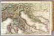
France 4.
1 : 1170000 Brue, Adrien Hubert, 1786-1832; Herisson, Eustache, b. 1759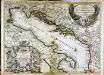
Le golfe de Venise
1 Karte : Kupferdruck ; 53 x 73 cm Sanson; Jaillot; Coronelli chez H. Jaillot
Reiseskizze der 12. Termifahrt S.M.S. Najade
Jaderské moře Cori, Carl J. K. u. k. Kriegsmarine
Skelettkarte des Adriatischen-Meeres für Kursskizzen
Jaderské moře K. u. k. Kriegsmarine
Italia Antiqva
1 : 8400000 Mollova mapová sbírka Clüver, Philipp Fuhrmann, Mathias
Le golfe de Venise
1 Karte : Kupferdruck ; 51 x 58 cm Fer; Starckman chez l'auteur dans l'isle du Palais sur le quay de l'Orloge a la Sphere Royale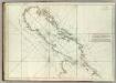
Carte De La Mer Mediterranee. VII.
Roux, Joseph
Pannoniae, Et Illyrici Veteris Tabula. [Karte], in: Theatrum orbis terrarum, S. 484.
1 Karte aus Atlas Ortelius, Abraham Vrients, Jan Baptista
Le Golfe de Venise
1 : 400000 Mollova mapová sbírka Sanson, Guillaume Jaillot, Alexis Hubert
Karta o dubljinama Jadranskoga mora
Jaderské moře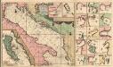
Pas-Caart-van de Weder zytsche Zee-kusten soo van Italia als Dalmatia en Griecken Inde Golff van Venetien
1 : 1400000 Mollova mapová sbírka Keulen, Gerard van Keulen, Gerard van
Carta postale e stradale dell'Italia
1 : 1050000 Itálie Pinneti, G. A. F. Artaria
Carte de geographie des differents etats de la republique de Venise, l'abregé de son gouvernement politique et ecclesiastique, et les etats ou elle a porté la gloire de ses armes
1 : 4300000 Benátky-oblast (Itálie) Chatelain, Henri-Abraham Chatelain
Carte d'une partie de l'Italie, pour servir à l'itinéraire d'un voyage fait dans ce pays, par Petit-Radel, en 1811 et 1812
1 : 2500000 [S.l.] : [s.n.]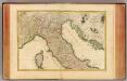
L'Italie septentrionale.
1 : 2050000 Rizzi Zannoni, Giovanni Antonio Bartolomeo, 1736-1814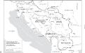
Jugoslawien nach dem Zweiten Weltkrieg (bis 1991) mit Republiken und Autonomen Provinzen
1 : 2500000 Jugoslawien Clewing, Konrad ; John, Holger W.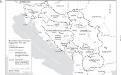
Staatenbildung im ehemaligen Jugoslawien, 1991 - 2008
1 : 2500000 Jugoslawien Auflösung, Staatenbildung Clewing, Konrad ; John, Holger W.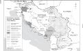
Besetzung und territoriale Aufteilung Jugoslawiens im Zweiten Weltkrieg
1 : 2500000 Jugoslawien Besetzung, Weltkrieg <1939-1945> Clewing, Konrad ; John, Holger W.
Pannoniae, Et Illyrici Veteris Tabula. [Karte], in: Theatrum orbis terrarum, S. 383.
1 Karte aus Atlas Ortelius, Abraham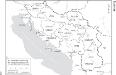
Die administrative Einteilung des Königreiches Jugoslawien nach Banschaften/banovine (ab 1929)
1 : 2500000 Jugoslawien Verwaltungsgliederung Clewing, Konrad ; John, Holger W.
Adriatischer Dienst inclusive Corfu u. Prevesa
Jaderské moře-oblast